Environmental Pollution ( IF 7.6 ) Pub Date : 2020-07-03 , DOI: 10.1016/j.envpol.2020.115132 Tanbir Singh 1 , Akash Biswal 2 , Sahil Mor 3 , Khaiwal Ravindra 4 , Vikas Singh 5 , Suman Mor 1
|
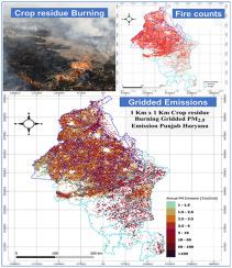
Emissions from the crop residue burning adversely affect the regional and global air quality including public health risks. In this study, a district-wise comprehensive emission inventory of key pollutants (PM2.5, PM10, CO, CO2, SO2, NOx, N2O, NH3, CH4, NMVOC, EC, OC, PAH) emitted during primary crop residue burning was developed using activity data for the major agrarian states of north India for the agricultural year 2017–18. The emissions were scaled to the spatial resolution of 1 km grid to study the spatial distribution of crop residue burning activities using VIIRS Thermal anomalies datasets. An estimated 20.3 Mt and 9.6 Mt of crop residue were burned in Punjab and Haryana, resulting in an emission of 137.2 Gg and 56.9 Gg of PM2.5 and 163.7 Gg and 72.1 of PM10 Gg for respective states. The emissions of EC, OC, and PAHs were 8.6 Gg, 45.7 Gg, and 0.08 Gg in Punjab, whereas in Haryana emissions were 3.7 Gg, 17.7 Gg, and 0.03 Gg, respectively. The results show that rice and wheat crops were major contributor to residue burnt at the field (>90%) leading to the high load of atmospheric emissions in the IGP region. Further, CO2 equivalent greenhouse gas emissions were 34.8 Tg and 17.3 Tg for Punjab and Haryana, respectively. Around 30000 and 8500 active fires were detected by VIIRS over the agricultural area of Punjab and Haryana during the studied year. The GIS-based bottom-up approach using gridded emission inventory shows pollutant distribution dominates over the south-western part of Punjab and north-western region of Haryana. The proximity of these regions to Delhi and transboundary movement of emissions towards Indo-Gangetic plains causes high air pollution episodes. The high-resolution inventory of various pollutants will be useful for regional air quality models to better predict and manage the hotspot of air pollution.
中文翻译:
基于VIIRS热异常,对印度北部燃烧的主要农作物残渣产生的空气污染物的高分辨率排放清单。
作物残渣燃烧产生的排放会对区域和全球空气质量产生不利影响,包括公共健康风险。在这项研究中,对关键污染物(PM 2.5,PM 10,CO,CO 2,SO 2,NOx,N 2 O,NH 3,CH 4,主要作物残渣燃烧过程中排放的NMVOC,EC,OC,PAH)是根据印度北部主要农业州2017-18财年的活动数据得出的。使用VIIRS热异常数据集将排放量缩放为1 km网格的空间分辨率,以研究作物残渣燃烧活动的空间分布。的估计20.3 MT和作物残余物的9.6亿吨旁遮普和哈里亚纳被烧毁,从而导致137.2千兆克的发射和PM 56.9千兆克2.5 72.1 PM的和163.7 GG和10各自状态的Gg。旁遮普邦的EC,OC和PAHs排放分别为8.6 Gg,45.7 Gg和0.08 Gg,而在哈里亚纳邦,分别为3.7 Gg,17.7 Gg和0.03 Gg。结果表明,稻米和小麦作物是造成田间焚烧残渣的主要因素(> 90%),导致IGP地区的大气排放量很高。此外,CO 2旁遮普邦和哈里亚纳邦的等效温室气体排放量分别为34.8 Tg和17.3 Tg。在所研究的年份中,VIIRS在旁遮普邦和哈里亚纳邦的农业地区发现了约30000起和8500起活跃火灾。基于GIS的自下而上方法(使用网格排放清单)显示,污染物分布在旁遮普西南部地区和哈里亚纳邦西北部地区占主导地位。这些地区靠近德里,排放物越境转移到印度-恒河平原,导致空气污染高发。各种污染物的高分辨率清册将有助于区域空气质量模型更好地预测和管理空气污染的热点。


 京公网安备 11010802027423号