Journal of Transport & Health ( IF 3.2 ) Pub Date : 2020-07-02 , DOI: 10.1016/j.jth.2020.100879 Amrit Kumar , Rajeev Kumar Mishra , Kiranmay Sarma
|
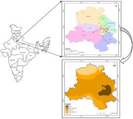
The present study undertakes to understand the spatial influence of traffic-induced criteria air pollutants and associated health risks assessment at major transport corridors in Delhi. The study includes the classification of vehicular pollutants parameters into five different distribution categories, i.e., low, moderately low, moderate, moderately high, and high. Spatial distribution maps were developed using Geographic Information System (GIS) environment for eleven districts covering 36 transport corridors of the city. The study demonstrated the concentration of three out of the five ambient air pollutants, namely, NOx, PM10 and PM2.5, with highest values in the range of 294.10–362.57, 203.99–422.42 and 333.71–541.72 μg/m3, respectively. Corresponding National Ambient Air Quality Standards (NAAQS) values were found to be grossly violated as reflected by NOx, PM2.5 and PM10 concentrations with 2–5 times higher values. Remaining two (CO and SOx) were found to be under permissible limits, and most of them exhibited low levels of observed concentrations. The ambient air quality in south, central, east, and New Delhi areas were found to be in high and moderately high categories and necessitating adequate control measures. The study reported a total of 281107, 20791, 31636 expected cases of human exposure to respiratory mortality, cardiovascular mortality and total mortality, respectively whereas, 281107 and 71608 number of cases were reported in relation to respiratory morbidity in terms of COPD hospital admission and cardiovascular morbidity along the transport corridors. The outcome of the study may provide a basis for decision makers to formulate the policy as per the scale of impact of traffic induced air pollution in critical areas around the major transport corridors.
中文翻译:
在德里使用克里格插值工具绘制交通诱发标准污染物和相关健康风险的空间分布图
本研究旨在了解德里主要交通走廊的交通诱发标准空气污染物的空间影响和相关的健康风险评估。该研究将车辆污染物参数分为五个不同的分布类别,即低,中低,中,中高和高。使用地理信息系统(GIS)环境为覆盖该城市36条交通走廊的11个地区开发了空间分布图。研究表明,五种环境空气污染物中的三种污染物的浓度分别为NOx,PM 10和PM 2.5,其最高值在294.10–362.57、203.99–422.42和333.71–541.72μg/ m 3之间。, 分别。发现NOx,PM 2.5和PM 10反映出严重违反了相应的国家环境空气质量标准(NAAQS)值浓度高2-5倍。发现其余两个(CO和SOx)均在允许的范围内,并且大多数都显示出较低的观察到浓度。发现南部,中部,东部和新德里地区的环境空气质量属于高中等级,需要采取适当的控制措施。该研究报告预期分别有281107、20791、31636例人类暴露于呼吸道疾病,心血管疾病和总死亡率的人,而据报道,与COPD住院和心血管疾病有关的呼吸道疾病的病例数为281107和71608运输走廊沿线的发病率。


 京公网安备 11010802027423号