当前位置:
X-MOL 学术
›
Int. J. Climatol.
›
论文详情
Our official English website, www.x-mol.net, welcomes your
feedback! (Note: you will need to create a separate account there.)
Rainfall estimation methods in the Brazilian semiarid region: 30‐year evaluation on a monthly scale
International Journal of Climatology ( IF 3.5 ) Pub Date : 2020-06-30 , DOI: 10.1002/joc.6723 Vitor Juste Santos 1 , Maria Lúcia Calijuri 1 , José Ivo Ribeiro Júnior 2 , Leonardo Campos Assis 3
International Journal of Climatology ( IF 3.5 ) Pub Date : 2020-06-30 , DOI: 10.1002/joc.6723 Vitor Juste Santos 1 , Maria Lúcia Calijuri 1 , José Ivo Ribeiro Júnior 2 , Leonardo Campos Assis 3
Affiliation
|
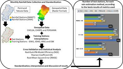
Studies about evaluations of different rainfall estimation methods are important as they are usually applied in works related to water resources availability, public supply, watering, animal water supply, hydroelectric power generation, drought episodes' evaluation, among others. Studies that cover the entire area of the Brazilian semiarid within this scope are still scarce. In this context, the objective of this paper was to evaluate seven rain estimation methods, from different approaches, with the aid of statistical analysis. The focus was on the long term, using 30 years of data in monthly scale, in order to verify the methods performance in estimating the spatiotemporal behaviour of rainfall compared to data measured in situ, coming from rainfall and meteorological stations. The evaluation process was based on the random selection of training and testing stations, with the first being used to interpolate rainfall data using different methods, and the latter used to evaluate this estimates with the aid of statistical analysis. Finally, the results were standardized, interpreted and discussed. Of all the estimation methods evaluated, CHIRPS obtained the best performance when compared to field stations data used as test. From the results obtained, there is evidence that the best performance is due to the incorporation of several distinct data sources derived from in situ stations, geostationary satellite infrared sensor estimates and physiographic predictors. This information is not fully present in other evaluated methods. The worst estimation performances were in the eastern side of the Brazilian semiarid, an area that receives moisture from the Atlantic Ocean and has significant topographic variations, due to the set of the complex relief mountains present in the northeast coast of Brazil.
中文翻译:

巴西半干旱地区的降雨估算方法:每月进行30年评估
关于不同降雨估算方法评估的研究很重要,因为它们通常用于与水资源可用性,公共供应,灌溉,动物供水,水力发电,干旱事件评估等相关的工作。涵盖该范围内巴西半干旱地区整个地区的研究仍然很少。在这种情况下,本文的目的是借助统计分析来评估来自不同方法的七种降雨估算方法。重点是长期的研究,每月使用30年的数据,以便与来自降雨和气象站的实地测量数据相比,验证方法在估计降雨时空行为方面的性能。评估过程基于对培训和测试站的随机选择,第一个用于使用不同方法对降雨数据进行插值,而第二个则用于借助统计分析评估该估计值。最后,对结果进行了标准化,解释和讨论。在评估的所有估计方法中,与用作测试的现场站数据相比,CHIRPS表现最佳。从获得的结果来看,有证据表明,最佳性能是归因于几个原位站,对地静止卫星红外传感器估计值和地物预测指标的不同数据源的合并。此信息在其他评估方法中并未完全存在。预估效果最差的是巴西半干旱地区的东部,
更新日期:2020-06-30
中文翻译:
巴西半干旱地区的降雨估算方法:每月进行30年评估
关于不同降雨估算方法评估的研究很重要,因为它们通常用于与水资源可用性,公共供应,灌溉,动物供水,水力发电,干旱事件评估等相关的工作。涵盖该范围内巴西半干旱地区整个地区的研究仍然很少。在这种情况下,本文的目的是借助统计分析来评估来自不同方法的七种降雨估算方法。重点是长期的研究,每月使用30年的数据,以便与来自降雨和气象站的实地测量数据相比,验证方法在估计降雨时空行为方面的性能。评估过程基于对培训和测试站的随机选择,第一个用于使用不同方法对降雨数据进行插值,而第二个则用于借助统计分析评估该估计值。最后,对结果进行了标准化,解释和讨论。在评估的所有估计方法中,与用作测试的现场站数据相比,CHIRPS表现最佳。从获得的结果来看,有证据表明,最佳性能是归因于几个原位站,对地静止卫星红外传感器估计值和地物预测指标的不同数据源的合并。此信息在其他评估方法中并未完全存在。预估效果最差的是巴西半干旱地区的东部,


 京公网安备 11010802027423号