当前位置:
X-MOL 学术
›
Meteorol. Appl.
›
论文详情
Our official English website, www.x-mol.net, welcomes your
feedback! (Note: you will need to create a separate account there.)
GIS and remote sensing techniques for the estimation of dew volume in the Republic of Serbia
Meteorological Applications ( IF 2.3 ) Pub Date : 2020-06-28 , DOI: 10.1002/met.1930 Aleksandar Valjarević 1, 2 , Dejan Filipović 3 , Dragana Valjarević 4 , Miško Milanović 3 , Slaviša Milošević 5 , Neboјša Živić 5 , Tin Lukić 6
Meteorological Applications ( IF 2.3 ) Pub Date : 2020-06-28 , DOI: 10.1002/met.1930 Aleksandar Valjarević 1, 2 , Dejan Filipović 3 , Dragana Valjarević 4 , Miško Milanović 3 , Slaviša Milošević 5 , Neboјša Živić 5 , Tin Lukić 6
Affiliation
|
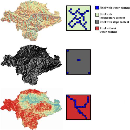
With the help of satellite data and numerical geographical information system (GIS) methods, the total capacity of dew volume on the entire territory of the Republic of Serbia was estimated. Multicriteria GIS analysis and satellite detections with the support of methods such as kriging and semi‐kriging gave satisfactory results in the present research. After the download of satellite data, they were compared with meteorological data for precipitation, evaporation and air temperature. A very precise grid in 1 × 1° of longitude and latitude was created. The average estimated dew potential for the territory of Serbia is 20–40 mm⋅year−1 for the south of the country, 15 mm⋅year−1 for the north, 30–50 mm⋅year−1 for the central region and 20–30 mm⋅year−1 for the east. In most drought regions, it is < 10 mm⋅year−1⋅m−2. Counties with the largest dew capacity (between 15,200 and 20,000 L) include Borski, Nišavski and Jablanički in the eastern part of the country, as well as Zlatiborski, Raški and Peć in the western and southern parts, respectively. On the other hand, counties with the lowest dew capacity (2,000–3,000 L) encompass northern parts of Serbia (Sremski, Severno‐Banatski, Srednje‐Banatski, Južno‐Banatski, Severno‐Bački and Zapadno‐Bački). The possibility for dew use is particularly strong during the spring. The estimated total capacity of the dew potential for Serbia is 1.5 × 10⁷ L. By comparing the obtained data for Serbia, it is concluded that the amount of this type of water resource is not large, but enough for use in agricultural and other economic sectors.
中文翻译:

GIS和遥感技术估算塞尔维亚共和国的露水量
借助卫星数据和数字地理信息系统(GIS)方法,估计了塞尔维亚共和国整个领土上的露水总量。在克里金法和半克里金法等方法的支持下,多准则GIS分析和卫星探测在本研究中获得了令人满意的结果。下载卫星数据后,将它们与气象数据进行了降水,蒸发和气温的比较。创建了一个经度和纬度为1×1°的非常精确的网格。塞尔维亚领土的平均预估露潜力为20-40mm⋅year -1为国家的南部,15mm⋅year -1为北,30-50mm⋅year -1促进中部地区崛起和20 –30mm⋅year-1代表东方。在大多数干旱地区,其<10mm⋅year - 1⋅m -2。露水量最大的县(介于15,200至20,000升之间)包括该国东部的Borski,Nišavski和Jablanički,以及西部和南部的Zlatiborski,Raški和Peć。另一方面,露水量最低的县(2,000–3,000升)包括塞尔维亚北部地区(Sremski,Severno-Banatski,Srednje-Banatski,Južno-Banatski,Severno-Bački和Zapadno-Bački)。在春季,使用露水的可能性特别大。塞尔维亚的潜在露水总容量约为1.5×10 7 L.通过比较所获得的塞尔维亚数据,可以得出结论,这种类型的水资源量不大,但足以用于农业和其他经济部门。
更新日期:2020-06-28
中文翻译:
GIS和遥感技术估算塞尔维亚共和国的露水量
借助卫星数据和数字地理信息系统(GIS)方法,估计了塞尔维亚共和国整个领土上的露水总量。在克里金法和半克里金法等方法的支持下,多准则GIS分析和卫星探测在本研究中获得了令人满意的结果。下载卫星数据后,将它们与气象数据进行了降水,蒸发和气温的比较。创建了一个经度和纬度为1×1°的非常精确的网格。塞尔维亚领土的平均预估露潜力为20-40mm⋅year -1为国家的南部,15mm⋅year -1为北,30-50mm⋅year -1促进中部地区崛起和20 –30mm⋅year-1代表东方。在大多数干旱地区,其<10mm⋅year - 1⋅m -2。露水量最大的县(介于15,200至20,000升之间)包括该国东部的Borski,Nišavski和Jablanički,以及西部和南部的Zlatiborski,Raški和Peć。另一方面,露水量最低的县(2,000–3,000升)包括塞尔维亚北部地区(Sremski,Severno-Banatski,Srednje-Banatski,Južno-Banatski,Severno-Bački和Zapadno-Bački)。在春季,使用露水的可能性特别大。塞尔维亚的潜在露水总容量约为1.5×10 7 L.通过比较所获得的塞尔维亚数据,可以得出结论,这种类型的水资源量不大,但足以用于农业和其他经济部门。


 京公网安备 11010802027423号