Journal of Environmental Management ( IF 8.0 ) Pub Date : 2020-06-26 , DOI: 10.1016/j.jenvman.2020.110950 Noura Bakr 1 , Osama R Abd El-Kawy 2
|
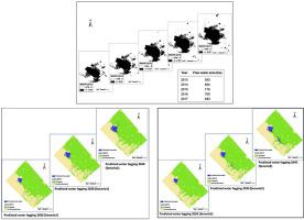
Land reclamation is critically required to overcome the environmental and anthropogenic challenges in arid lands. The Western Nile Delta region, Egypt, is experiencing rapid reclamation processes for agriculture expansion. West Nubaria (781.92 km2) is one of the newly reclaimed areas in the Western Nile Delta. Due to extensive agricultural practices and poor management, an artificial saline lake formed in this area. Two primary goals of this research; 1) monitoring the annual change in the lake surface area between 2013 and 2017. 2) Predicting the areal extent of the lake surface in 2020, 2030, and 2040 based on two management scenarios. The maximum likelihood classifier (MLC) was applied to distinguish the LULC classes in 2017. Additionally, the annual modified normalized difference water index (MNDWI) calculated between 2013 and 2017. Then, the land change modeler (LCM) was utilized to predict the 2017 free water area based on the resulted MNDWI maps of 2013 and 2016 using two scenarios. With the high agreement between the actual and predicting free water area of 2017 (Kappa index = 0.93), the LCM was applied to predict the future surface water expansion in 2020, 2030, and 2040. Three land use/land cover (LULC) distinguished in 2017; agricultural land, uncultivated land, and free water class based on MLC. The MNDWI results reveal that there was an increase in the surface water area from 593 to 883 ha between 2013 and 2017, respectively. The LCM results indicate that expected increases in the surface water areas of 1068, 1711, and 2267 ha in 2020, 2030 and 2040, respectively (scenario 1) and 1065, 1726, and 2343 ha in the respective dates (scenario 2). These extend will exist over the agricultural and uncultivated lands surrounding the lake causing land degradation. Two solutions were suggested to combat the waterlogging and land degradation in this area by evacuating the artificial saline lake.
中文翻译:
模拟干旱农业生态系统中的人工湖表面积变化:以新开垦区埃及为例。
为克服干旱地区的环境和人为挑战,迫切需要开垦土地。埃及西尼罗河三角洲地区正经历着快速的垦殖过程,以扩大农业规模。西努巴里亚(781.92 km 2)是西尼罗河三角洲新近开垦的地区之一。由于广泛的农业实践和管理不善,该地区形成了一个人工盐湖。这项研究的两个主要目标;1)监测2013年至2017年之间的湖面面积年度变化。2)根据两个管理方案预测2020年,2030年和2040年的湖面面积范围。应用最大似然分类器(MLC)来区分2017年的LULC类。此外,还计算了2013年至2017年之间的年度修正归一化差异水指数(MNDWI)。然后,利用土地变化建模器(LCM)来预测2017年基于两种情况的2013年和2016年MNDWI地图生成的自由水域。在2017年的实际水域面积与预测的自由水面积之间达成高度一致(Kappa指数= 0。93),将LCM应用于预测2020年,2030年和2040年的未来地表水扩展。2017年区分了三种土地利用/土地覆盖率(LULC);基于MLC的农地,非耕地和免费水位。MNDWI结果显示,2013年至2017年间,地表水面积分别从593公顷增加到883公顷。LCM结果表明,分别在2020年,2030年和2040年(情景1)和1065、1726和2343公顷(情景2)的地表水面积预期分别增加1068、1711和2267公顷。这些扩展将存在于围绕湖的农业和未耕地上,从而导致土地退化。建议通过疏散人工盐湖来解决该地区的涝灾和土地退化问题的两种解决方案。应用LCM预测了2020年,2030年和2040年的未来地表水扩展。2017年区分了三个土地利用/土地覆被(LULC)。基于MLC的农地,非耕地和免费水位。MNDWI结果显示,2013年至2017年间,地表水面积分别从593公顷增加到883公顷。LCM结果表明,预计在2020年,2030年和2040年(情景1)的地表水面积分别增加1068、1711和2267公顷(情景1),在各个日期分别增加1065、1726和2343公顷(情景2)。这些扩展将存在于围绕湖的农业和未耕地上,从而导致土地退化。建议通过疏散人工盐湖来解决该地区的涝灾和土地退化问题的两种解决方案。应用LCM预测了2020年,2030年和2040年的未来地表水扩展。2017年区分了三个土地利用/土地覆被(LULC);基于MLC的农地,非耕地和免费水位。MNDWI结果显示,2013年至2017年间,地表水面积分别从593公顷增加到883公顷。LCM结果表明,预计在2020年,2030年和2040年(情景1)的地表水面积分别增加1068、1711和2267公顷(情景1),在各个日期分别增加1065、1726和2343公顷(情景2)。这些扩展将存在于围绕湖的农业和未耕地上,从而导致土地退化。建议通过疏散人工盐湖来解决该地区的涝灾和土地退化问题的两种解决方案。


 京公网安备 11010802027423号