Our official English website, www.x-mol.net, welcomes your
feedback! (Note: you will need to create a separate account there.)
Multi-task convolutional neural networks outperformed random forest for mapping soil particle size fractions in central Iran
Geoderma ( IF 5.6 ) Pub Date : 2020-10-01 , DOI: 10.1016/j.geoderma.2020.114552 R. Taghizadeh-Mehrjardi , M. Mahdianpari , F. Mohammadimanesh , T. Behrens , N. Toomanian , T. Scholten , K. Schmidt
Geoderma ( IF 5.6 ) Pub Date : 2020-10-01 , DOI: 10.1016/j.geoderma.2020.114552 R. Taghizadeh-Mehrjardi , M. Mahdianpari , F. Mohammadimanesh , T. Behrens , N. Toomanian , T. Scholten , K. Schmidt
|
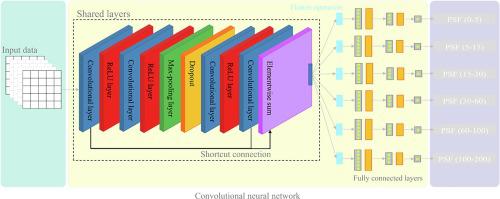
Abstract Knowledge about the spatial distribution of soil particle size fractions (PSF) is critical for sustainable management and resource assessment of the agricultural regions. Although conventional machine learning algorithms, such as random forest (RF) or support vector machine, have been extensively used in digital soil mapping to predict the PSF, less research examined the potential of state-of-the-art deep learning approaches for such processing. Importantly, deep learning approaches such as convolutional neural networks (CNNs) are able to incorporate contextual information about the landscape, which is of great use for DSM analysis. Accordingly, this study addresses this much-needed investigation by using a patch-based, multi-task CNN for predicting PSF of clay, sand, and silt contents at six standard layers given as soil depth increments as recommended by the GlobalSoilMap.net (i.e., 0–5, 5–15, 15–30, 30–60, 60–100, 100–200 cm). The depth functions were derived from equal-area smoothing splines in a region covering large parts (~140,000 km2) of central Iran. The robustness of the proposed architecture is evaluated against RF. Additionally, to allow a fairer comparison between RF and CNN models, we used simple smoothing (mean) filters to effectively reproduce the auxiliary data which are then fed in the RF (RF*). To evaluate the three models, we established a training (75%) and test set (25%). According to the test set, for all soil depths and all PSFs, the results demonstrate that CNN consistently outperforms RF and RF* in terms of root mean square error (RMSE) and coefficient of determination (R2). At the top layer, for example, CNN decreased the RMSE values for clay, sand, and silt contents compared to the RF (22.4%, 18.9%, and 10.7%) and RF* (18.0%, 7.4%, and 9.6%). These findings indicate that even the use of feature-engineered auxiliary data did not enable the RF* models to reach the performance of CNN. The resulting maps can be used as valuable baseline soil information for the effective management of agricultural and environmental resources in the study area and beyond.
中文翻译:

多任务卷积神经网络在绘制伊朗中部土壤粒度分数方面优于随机森林
摘要 关于土壤粒度分数 (PSF) 空间分布的知识对于农业区域的可持续管理和资源评估至关重要。尽管随机森林 (RF) 或支持向量机等传统机器学习算法已广泛用于数字土壤制图以预测 PSF,但很少有研究检查最先进的深度学习方法在此类处理中的潜力. 重要的是,卷积神经网络 (CNN) 等深度学习方法能够整合有关景观的上下文信息,这对于 DSM 分析非常有用。因此,本研究通过使用基于补丁的多任务 CNN 来预测粘土、沙子、和六个标准层的淤泥含量,以 GlobalSoilMap.net 推荐的土壤深度增量给出(即 0-5、5-15、15-30、30-60、60-100、100-200 厘米)。深度函数来自覆盖伊朗中部大部分地区(~140,000 平方公里)的等面积平滑样条。建议架构的稳健性是针对 RF 进行评估的。此外,为了在 RF 和 CNN 模型之间进行更公平的比较,我们使用简单的平滑(均值)滤波器来有效地再现辅助数据,然后将这些辅助数据输入 RF (RF*)。为了评估这三个模型,我们建立了训练集 (75%) 和测试集 (25%)。根据测试集,对于所有土壤深度和所有 PSF,结果表明 CNN 在均方根误差 (RMSE) 和决定系数 (R2) 方面始终优于 RF 和 RF*。例如,在顶层,与 RF(22.4%、18.9% 和 10.7%)和 RF*(18.0%、7.4% 和 9.6%)相比,CNN 降低了粘土、沙子和淤泥含量的 RMSE 值. 这些发现表明,即使使用特征工程辅助数据也无法使 RF* 模型达到 CNN 的性能。生成的地图可用作有价值的基线土壤信息,用于有效管理研究区及其他地区的农业和环境资源。
更新日期:2020-10-01
中文翻译:
多任务卷积神经网络在绘制伊朗中部土壤粒度分数方面优于随机森林
摘要 关于土壤粒度分数 (PSF) 空间分布的知识对于农业区域的可持续管理和资源评估至关重要。尽管随机森林 (RF) 或支持向量机等传统机器学习算法已广泛用于数字土壤制图以预测 PSF,但很少有研究检查最先进的深度学习方法在此类处理中的潜力. 重要的是,卷积神经网络 (CNN) 等深度学习方法能够整合有关景观的上下文信息,这对于 DSM 分析非常有用。因此,本研究通过使用基于补丁的多任务 CNN 来预测粘土、沙子、和六个标准层的淤泥含量,以 GlobalSoilMap.net 推荐的土壤深度增量给出(即 0-5、5-15、15-30、30-60、60-100、100-200 厘米)。深度函数来自覆盖伊朗中部大部分地区(~140,000 平方公里)的等面积平滑样条。建议架构的稳健性是针对 RF 进行评估的。此外,为了在 RF 和 CNN 模型之间进行更公平的比较,我们使用简单的平滑(均值)滤波器来有效地再现辅助数据,然后将这些辅助数据输入 RF (RF*)。为了评估这三个模型,我们建立了训练集 (75%) 和测试集 (25%)。根据测试集,对于所有土壤深度和所有 PSF,结果表明 CNN 在均方根误差 (RMSE) 和决定系数 (R2) 方面始终优于 RF 和 RF*。例如,在顶层,与 RF(22.4%、18.9% 和 10.7%)和 RF*(18.0%、7.4% 和 9.6%)相比,CNN 降低了粘土、沙子和淤泥含量的 RMSE 值. 这些发现表明,即使使用特征工程辅助数据也无法使 RF* 模型达到 CNN 的性能。生成的地图可用作有价值的基线土壤信息,用于有效管理研究区及其他地区的农业和环境资源。


 京公网安备 11010802027423号