Catena ( IF 5.4 ) Pub Date : 2020-06-26 , DOI: 10.1016/j.catena.2020.104758 Jarosław Cebulski , Bernadetta Pasierb , Dariusz Wieczorek , Artur Zieliński
|
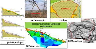
Landslides are a major threat to the environment, infrastructure and human activities, especially in mountainous and hilly areas. It is therefore important to accurately identify the mass movements triggering these mechanisms. This paper presents the impacts of lithotectonic conditions on the formation of mass movements on the example of the landslide that is located in the northern part of the Polish Outer Carpathians. In the area of the research, the ratio of the total area of landslides to the surface of the area reaches even 20%. The interpretation of a high resolution Digital Elevation Model (DEM), Electrical Resistivity Tomography (ERT) and fieldwork results allowed for the reconstruction of the landslide movements and dividing them into two areas; the western one, dominated by rotational movement, and the eastern one, featuring rotational and translational movement. It was found that the eastern part is more active now as it probably was also in the past, which might have resulted from the lithotectonic conditioned or from the impact of the flowing waters of the Dunajec River. Moreover, in the eastern part of the landslides, a small-sized ridge (55 m × 25 m) was identified, which shows greater stability in comparison with the colluvium that surrounds it. In order to explain the lower rate of movement of this landform, a morphometric analysis and research using ERT were performed. The geophysical measurements showed that the ridge comprised rock formations of greater resistivity than its surroundings. It is most likely that the only preserved sandstone packet, constituting the original secondary escarpment, became separated from the bedrock due to rotational movement. The presented studies indicate that the landslide was created due to geological and atmospheric conditions. A clear revival of landslide movements took place after significant precipitation events that last occurred in the years 2010 and 2015. The bedrock substrate due to its lithology and tectonics, facilitates these movements. It was found that the landslide studied is a complex entity, characteristic of the Polish Outer Carpathians, that has undergone multiple stages of development. The landslide is active or periodically active and, therefore, must be excluded from the planned development as well as from other forms of human activity.
中文翻译:
使用数字高程模型和电阻层析成像分析在波兰外喀尔巴阡山脉重建滑坡运动
滑坡是对环境,基础设施和人类活动的重大威胁,特别是在山区和丘陵地区。因此,准确识别触发这些机制的质量运动很重要。本文以位于波兰外喀尔巴阡山脉北部的滑坡为例,介绍了岩石构造条件对质量运动形成的影响。在研究领域,滑坡总面积与表面面积之比甚至达到20%。对高分辨率数字高程模型(DEM),电阻率层析成像(ERT)和野外作业结果的解释,可以重建滑坡运动并将其分为两个区域;西方以旋转运动为主,东方是,具有旋转和平移运动。人们发现,东部地区现在比过去更活跃,这可能是由于岩石构造条件或杜纳耶茨河(Dunajec River)流水的影响所致。此外,在滑坡的东部,发现了一个小的山脊(55 m×25 m),与周围的坡地相比,其稳定性更高。为了解释该地貌的较低运动速率,进行了形态计量学分析和使用ERT的研究。地球物理测量结果表明,该山脊包括电阻率比其周围环境更大的岩层。唯一保留下来的砂岩小包很可能构成了原始的次要悬崖,由于旋转运动而与基岩分离。提出的研究表明,滑坡是由于地质和大气条件造成的。在上一次发生在2010年和2015年的重大降水事件之后,滑坡运动发生了明显的复苏。基岩基底由于其岩性和构造学而促进了这些运动。发现所研究的滑坡是一个复杂的实体,具有波兰外喀尔巴阡山脉的特征,经历了多个发展阶段。滑坡是活动的或周期性的活动,因此,必须将其排除在计划开发以及其他形式的人类活动之外。在上一次发生在2010年和2015年的重大降水事件之后,滑坡运动发生了明显的复苏。基岩基底由于其岩性和构造学而促进了这些运动。发现所研究的滑坡是一个复杂的实体,具有波兰外喀尔巴阡山脉的特征,经历了多个发展阶段。滑坡是活动的或周期性的活动,因此,必须将其排除在计划开发以及其他形式的人类活动之外。在上一次发生在2010年和2015年的重大降水事件之后,滑坡运动发生了明显的复苏。基岩基底由于其岩性和构造学而促进了这些运动。发现所研究的滑坡是一个复杂的实体,具有波兰外喀尔巴阡山脉的特征,经历了多个发展阶段。滑坡是活动的或周期性的活动,因此,必须将其排除在计划开发以及其他形式的人类活动之外。已经经历了多个发展阶段。滑坡是活动的或周期性的活动,因此,必须将其排除在计划开发以及其他形式的人类活动之外。已经经历了多个发展阶段。滑坡是活动的或周期性的活动,因此,必须将其排除在计划开发以及其他形式的人类活动之外。


 京公网安备 11010802027423号