当前位置:
X-MOL 学术
›
Trans. Emerg. Telecommun. Technol.
›
论文详情
Our official English website, www.x-mol.net, welcomes your
feedback! (Note: you will need to create a separate account there.)
Review on remote sensing methods for landslide detection using machine and deep learning
Transactions on Emerging Telecommunications Technologies ( IF 2.5 ) Pub Date : 2020-06-23 , DOI: 10.1002/ett.3998 Amrita Mohan 1 , Amit Kumar Singh 2 , Basant Kumar 3 , Ramji Dwivedi 1
Transactions on Emerging Telecommunications Technologies ( IF 2.5 ) Pub Date : 2020-06-23 , DOI: 10.1002/ett.3998 Amrita Mohan 1 , Amit Kumar Singh 2 , Basant Kumar 3 , Ramji Dwivedi 1
Affiliation
|
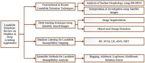
Landslide, one of the most critical natural hazards, is caused due to specific compositional slope movement. In the past decades, due to inflation of urbanized area and climate change, a compelling expansion in landslide prevalence took place which is also termed as mass/slope movement and mass wasting, causing extensive collapse around the world. The principal reason for its pursuance is a reduction in the internal resistance of soil and rocks, classified as a slide, topple, fall, and flow. Slopes can be differentiated based on earth material and the nature of its movements. The downward flow of landslides occurs due to excessive rainfall, snowmelt, earthquake, volcanic eruption, and so on. This review article revisits the conventional approaches for identification of landslides, predicting future risk, associated with slope failures, followed by emphasizing the advantages of modern geospatial techniques such as aerial photogrammetry, satellite remote sensing images (ie, panchromatic, multispectral, radar images), Terrestrial laser scanning, and High-Resolution Digital Elevation Model (HR-DEM) in updating landslide inventory maps. Machine learning techniques like Support Vector Machine, Artificial neural network, deep learning has been extensively used with geographical data producing effective results for assessment of natural hazard/resources and environmental research. Based on recent studies, deep learning is a reliable tool addressing remote sensing challenges such as trade-off in imaging system producing poor quality investigation, in addition, to expedite consequent task such as image recognition, object detection, classification, and so on. Conventional methods, like pixel and object-based machine learning methods, have been broadly explored. Advanced development in deep learning technique like CNN (Convolutional neural network) has been extensively successful in information extraction from an image and has exceeded other traditional approaches. Over the past few years, minor attempts have been made for landslide susceptibility mapping using CNN. In addition, small sample sizes for training purpose will be major drawback and notably remarkable while using deep learning techniques. Also, assessment of the model's performance with diverse training and testing proportion other than commonly utilized ratio, that is, 70/30 needs to be explored further. The review article briefly highlights the remote sensing methods for landslide detection using machine learning and deep learning.
中文翻译:

基于机器学习和深度学习的滑坡遥感检测方法综述
滑坡是最严重的自然灾害之一,它是由特定成分的斜坡运动引起的。在过去的几十年里,由于城市化地区的通货膨胀和气候变化,滑坡流行率急剧扩大,也被称为质量/斜坡移动和质量浪费,导致世界范围内的大面积崩塌。其追求的主要原因是减少土壤和岩石的内部阻力,分类为滑动、倾倒、坠落和流动。斜坡可以根据地球材料及其运动的性质进行区分。由于降雨过多、融雪、地震、火山喷发等原因导致滑坡向下流动。这篇评论文章重新审视了识别滑坡的传统方法,预测与边坡失稳相关的未来风险,其次强调现代地理空间技术,如航空摄影测量、卫星遥感图像(即全色、多光谱、雷达图像)、地面激光扫描和高分辨率数字高程模型(HR-DEM)在更新滑坡清单地图方面的优势. 支持向量机、人工神经网络、深度学习等机器学习技术已广泛用于地理数据,为评估自然灾害/资源和环境研究产生了有效的结果。根据最近的研究,深度学习是一种可靠的工具,可以解决遥感挑战,例如在成像系统中进行权衡,产生质量差的调查,此外,还可以加快后续任务,例如图像识别、对象检测、分类等。常规方法,像基于像素和基于对象的机器学习方法,已经被广泛探索。CNN(卷积神经网络)等深度学习技术的先进发展在从图像中提取信息方面取得了广泛的成功,并且已经超越了其他传统方法。在过去几年中,使用 CNN 对滑坡敏感性绘图进行了一些小尝试。此外,用于训练目的的小样本量将是主要缺点,并且在使用深度学习技术时尤为显着。此外,除了常用的比例,即 70/30 之外,还需要进一步探索使用不同的训练和测试比例来评估模型的性能。该评论文章简要介绍了使用机器学习和深度学习进行滑坡检测的遥感方法。
更新日期:2020-06-23
中文翻译:
基于机器学习和深度学习的滑坡遥感检测方法综述
滑坡是最严重的自然灾害之一,它是由特定成分的斜坡运动引起的。在过去的几十年里,由于城市化地区的通货膨胀和气候变化,滑坡流行率急剧扩大,也被称为质量/斜坡移动和质量浪费,导致世界范围内的大面积崩塌。其追求的主要原因是减少土壤和岩石的内部阻力,分类为滑动、倾倒、坠落和流动。斜坡可以根据地球材料及其运动的性质进行区分。由于降雨过多、融雪、地震、火山喷发等原因导致滑坡向下流动。这篇评论文章重新审视了识别滑坡的传统方法,预测与边坡失稳相关的未来风险,其次强调现代地理空间技术,如航空摄影测量、卫星遥感图像(即全色、多光谱、雷达图像)、地面激光扫描和高分辨率数字高程模型(HR-DEM)在更新滑坡清单地图方面的优势. 支持向量机、人工神经网络、深度学习等机器学习技术已广泛用于地理数据,为评估自然灾害/资源和环境研究产生了有效的结果。根据最近的研究,深度学习是一种可靠的工具,可以解决遥感挑战,例如在成像系统中进行权衡,产生质量差的调查,此外,还可以加快后续任务,例如图像识别、对象检测、分类等。常规方法,像基于像素和基于对象的机器学习方法,已经被广泛探索。CNN(卷积神经网络)等深度学习技术的先进发展在从图像中提取信息方面取得了广泛的成功,并且已经超越了其他传统方法。在过去几年中,使用 CNN 对滑坡敏感性绘图进行了一些小尝试。此外,用于训练目的的小样本量将是主要缺点,并且在使用深度学习技术时尤为显着。此外,除了常用的比例,即 70/30 之外,还需要进一步探索使用不同的训练和测试比例来评估模型的性能。该评论文章简要介绍了使用机器学习和深度学习进行滑坡检测的遥感方法。


 京公网安备 11010802027423号