当前位置:
X-MOL 学术
›
Earth Surf.Process. Land.
›
论文详情
Our official English website, www.x-mol.net, welcomes your
feedback! (Note: you will need to create a separate account there.)
Evaluating the performance of topobathymetric LiDAR to support multi‐dimensional flow modelling in a gravel‐bed mountain stream
Earth Surface Processes and Landforms ( IF 2.8 ) Pub Date : 2020-06-22 , DOI: 10.1002/esp.4934 Daniele Tonina 1 , James A. McKean 2 , Rohan M. Benjankar 3 , Elowyn Yager 1 , Richard A. Carmichael 4 , Qiuwen Chen 5 , Aston Carpenter 1 , Leah G. Kelsey 1 , Michael R. Edmondson 6
Earth Surface Processes and Landforms ( IF 2.8 ) Pub Date : 2020-06-22 , DOI: 10.1002/esp.4934 Daniele Tonina 1 , James A. McKean 2 , Rohan M. Benjankar 3 , Elowyn Yager 1 , Richard A. Carmichael 4 , Qiuwen Chen 5 , Aston Carpenter 1 , Leah G. Kelsey 1 , Michael R. Edmondson 6
Affiliation
|
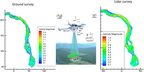
Stream biophysical processes are commonly studied using multi‐dimensional numerical modelling that quantifies flow hydraulics from which parameters such as habitat suitability, stream carrying capacity, and bed mobility are derived. These analyses would benefit from accurate high‐resolution stream bathymetries spanning tens of kilometres of channel, especially in small streams or where navigation is difficult. Traditional ground‐based survey methods are limited by survey time, dense vegetation and stream access, and are usually only feasible for short reaches. Conversely, airborne topobathymetric LiDAR surveys may overcome these limitations, although limited research is available on how errors in LiDAR‐derived digital elevation models (DEMs) might propagate through flow models. This study investigated the performance of LiDAR‐derived topobathymetry in support of multi‐dimensional flow modelling and ecohydraulics calculations in two gravel‐bedded reaches (approximately 200 m long), one morphologically complex and one morphologically simple, and at the segment scale (32 km‐long stream segment) along a 15 m‐wide river in central Idaho, USA. We compared metre and sub‐metre‐resolution DEMs generated from RTK‐GPS ground and Experimental Advanced Airborne Research LiDAR‐B (EAARL‐B) surveys and water depths, velocities, shear stresses, habitat suitability, and bed mobility modelled with two‐dimensional (2D) hydraulic models supported by LiDAR and ground‐surveyed DEMs. Residual statistics, bias (B), and standard deviation (SD) of the residuals between depth and velocity predicted from the model supported by LiDAR and ground‐survey topobathymetries were up to −0.04 (B) and 0.09 m (SD) for depth and −0.09 (B) and 0.20 m s−1 (SD) for velocity. The accuracy (B = 0.05 m), precision (SD = 0.09 m), and point density (1 point m−2) of the LiDAR topobathymetric survey (regardless of reach complexity) were sufficient to support 2D hydrodynamic modelling and derivative stream habitat and process analyses, because these statistics were comparable to those of model calibration with B = 0 m and SD = 0.04 m for water surface elevation and B = 0.05 m s−1 and SD = 0.22 m s−1 for velocity in our investigation. © 2020 John Wiley & Sons, Ltd.
中文翻译:

评估地形测压LiDAR的性能以支持砾石床山流中的多维流建模
通常使用多维数值模型研究河流的生物物理过程,该模型对流动的水力进行量化,并从中得出诸如栖息地的适宜性,河流的承载能力和床的流动性等参数。这些分析将受益于跨越数十公里通道的准确的高分辨率河流测深仪,尤其是在小溪流或导航困难的地方。传统的地面调查方法受调查时间,茂密的植被和溪流限制,通常仅适用于短距离。相反,尽管对LiDAR衍生的数字高程模型(DEMs)中的误差如何通过流量模型传播的方法的研究还很有限,但机载拓扑肺LiDAR测量可能克服了这些限制。这项研究调查了在两个砾石层段河段(约200 m长),一个形态复杂而一个形态简单以及分段规模(32 km)下,LiDAR拓扑地形测量法在多维流模型和生态液压计算方面的支持。长流段),位于美国爱达荷州中部15米宽的河流上。我们比较了从RTK‐GPS地面和实验性先进机载研究LiDAR‐B(EAARL‐B)调查生成的米和亚微米分辨率的DEM,并使用二维建模的水深,速度,切应力,栖息地适应性和床层流动性LiDAR和地面测量的DEM支持的(2D)液压模型。残留统计量,偏差(B),-1(SD)表示速度。LiDAR地形测量的精度(B = 0.05 m),精度(SD = 0.09 m)和点密度(1 point m -2)(无论到达复杂度如何)足以支持2D流体动力学建模和导流生境和过程分析,因为在我们的研究中,这些统计量与模型标定具有可比性,其中B = 0 m且SD = 0.04 m(水面高度),B = 0.05 ms -1且SD = 0.22 m s -1。分级为4 +©2020 John Wiley&Sons,Ltd.
更新日期:2020-06-22
中文翻译:
评估地形测压LiDAR的性能以支持砾石床山流中的多维流建模
通常使用多维数值模型研究河流的生物物理过程,该模型对流动的水力进行量化,并从中得出诸如栖息地的适宜性,河流的承载能力和床的流动性等参数。这些分析将受益于跨越数十公里通道的准确的高分辨率河流测深仪,尤其是在小溪流或导航困难的地方。传统的地面调查方法受调查时间,茂密的植被和溪流限制,通常仅适用于短距离。相反,尽管对LiDAR衍生的数字高程模型(DEMs)中的误差如何通过流量模型传播的方法的研究还很有限,但机载拓扑肺LiDAR测量可能克服了这些限制。这项研究调查了在两个砾石层段河段(约200 m长),一个形态复杂而一个形态简单以及分段规模(32 km)下,LiDAR拓扑地形测量法在多维流模型和生态液压计算方面的支持。长流段),位于美国爱达荷州中部15米宽的河流上。我们比较了从RTK‐GPS地面和实验性先进机载研究LiDAR‐B(EAARL‐B)调查生成的米和亚微米分辨率的DEM,并使用二维建模的水深,速度,切应力,栖息地适应性和床层流动性LiDAR和地面测量的DEM支持的(2D)液压模型。残留统计量,偏差(B),-1(SD)表示速度。LiDAR地形测量的精度(B = 0.05 m),精度(SD = 0.09 m)和点密度(1 point m -2)(无论到达复杂度如何)足以支持2D流体动力学建模和导流生境和过程分析,因为在我们的研究中,这些统计量与模型标定具有可比性,其中B = 0 m且SD = 0.04 m(水面高度),B = 0.05 ms -1且SD = 0.22 m s -1。分级为4 +©2020 John Wiley&Sons,Ltd.


 京公网安备 11010802027423号