Ecological Indicators ( IF 7.0 ) Pub Date : 2020-06-21 , DOI: 10.1016/j.ecolind.2020.106620 Sk Ajim Ali , Farhana Parvin , Quoc Bao Pham , Matej Vojtek , Jana Vojteková , Romulus Costache , Nguyen Thi Thuy Linh , Hong Quan Nguyen , Ateeque Ahmad , Mohammad Ali Ghorbani
|
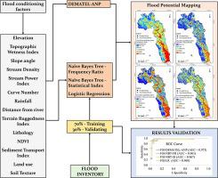
Flood is a devastating natural hazard that may cause damage to the environment infrastructure, and society. Hence, identifying the susceptible areas to flood is an important task for every country to prevent such dangerous consequences. The present study developed a framework for identifying flood-prone areas of the Topľa river basin, Slovakia using geographic information system (GIS), multi-criteria decision making approach (MCDMA), bivariate statistics (Frequency Ratio (FR), Statistical Index (SI)) and machine learning (Naïve Bayes Tree (NBT), Logistic Regression (LR)). To reach such a goal, different physical-geographical factors (criteria) were integrated and mapped. To access the relationship and interdependences among the criteria, decision-making trial and evaluation laboratory (DEMATEL) and analytic network process (ANP) were used. Based on the experts’ decisions, the DEMATEL-ANP model was used to compute the relative weights of different criteria and a GIS-based linear combination was performed to derive the susceptibility index. Separately, the flood susceptibility index computation through NBT-FR and NBT-SI hybrid models assumed, in the first stage, the estimation of the weight of each class/category of conditioning factor through SI and FR and the integration of these values in NBT algorithm. The application of LR stand-alone required the calculation of the weights of conditioning factors by analysing their spatial relation with the location of the historical flood events. The study revealed that very high and high flood susceptibility classes covered between 20% and 47% of the study area, respectively. The validation of results, using the past flood points, highlighted that the hybrid DEMATEL-ANP model was the most performant with an Area Under ROC curve higher than 0.97, an accuracy of 0.922 and a value of HSS of 0.844. The presented methodological approach used for the identification of flood susceptible areas can serve as an alternative for the updating of preliminary flood risk assessment based on the EU Floods Directive.
中文翻译:
使用混合多准则决策方法,朴素贝叶斯树,二元统计和Logistic回归的基于GIS的洪水敏感性制图比较评估:以斯洛伐克Topľa盆地为例
洪水是毁灭性的自然灾害,可能对环境基础设施和社会造成破坏。因此,确定易受洪灾的地区是每个国家防止此类危险后果的重要任务。本研究开发了一个框架,用于使用地理信息系统(GIS),多准则决策方法(MCDMA),双变量统计(频率比(FR),统计指数(SI))来识别斯洛伐克Topľa流域易发洪水的地区))和机器学习(朴素贝叶斯树(NBT),逻辑回归(LR))。为了实现这一目标,对不同的自然地理因素(标准)进行了整合和制图。为了访问标准之间的关系和相互依赖关系,使用了决策试验和评估实验室(DEMATEL)和分析网络过程(ANP)。根据专家的决定,使用DEMATEL-ANP模型计算不同标准的相对权重,并基于GIS的线性组合得出磁化率指数。另外,在第一阶段,通过NBT-FR和NBT-SI混合模型计算洪水敏感性指数时,假设通过SI和FR估算每个类别/类别的调节因子的权重,并将这些值集成到NBT算法中。LR独立应用程序需要通过分析条件因子与历史洪水事件的位置之间的空间关系来计算条件因子的权重。研究表明,很高和很高的洪水敏感性等级分别覆盖了研究区域的20%和47%。使用过去的洪水点验证结果,强调指出,混合的DEMATEL-ANP模型的性能最高,ROC曲线下面积大于0.97,精度为0.922,HSS值为0.844。提出的用于确定易受洪灾地区的方法学方法可以作为根据欧盟《洪水指令》更新初步洪水风险评估的替代方法。


 京公网安备 11010802027423号