Geoscience Frontiers ( IF 8.5 ) Pub Date : 2020-06-18 , DOI: 10.1016/j.gsf.2020.04.015 Hugo K.H. Olierook , Richard Scalzo , David Kohn , Rohitash Chandra , Ehsan Farahbakhsh , Chris Clark , Steven M. Reddy , R. Dietmar Müller
|
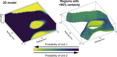
Traditional approaches to develop 3D geological models employ a mix of quantitative and qualitative scientific techniques, which do not fully provide quantification of uncertainty in the constructed models and fail to optimally weight geological field observations against constraints from geophysical data. Here, using the Bayesian Obsidian software package, we develop a methodology to fuse lithostratigraphic field observations with aeromagnetic and gravity data to build a 3D model in a small (13.5 km × 13.5 km) region of the Gascoyne Province, Western Australia. Our approach is validated by comparing 3D model results to independently-constrained geological maps and cross-sections produced by the Geological Survey of Western Australia. By fusing geological field data with aeromagnetic and gravity surveys, we show that 89% of the modelled region has >95% certainty for a particular geological unit for the given model and data. The boundaries between geological units are characterized by narrow regions with <95% certainty, which are typically 400–1000 m wide at the Earth’s surface and 500–2000 m wide at depth. Beyond ∼4 km depth, the model requires geophysical survey data with longer wavelengths (e.g., active seismic) to constrain the deeper subsurface. Although Obsidian was originally built for sedimentary basin application, there is reasonable applicability to deformed terranes such as the Gascoyne Province. Ultimately, modification of the Bayesian engine to incorporate structural data will aid in developing more robust 3D models. Nevertheless, our results show that surface geological observations fused with geophysical survey data can yield reasonable 3D geological models with narrow uncertainty regions at the surface and shallow subsurface, which will be especially valuable for mineral exploration and the development of 3D geological models under cover.
中文翻译:
贝叶斯地质和地球物理数据融合用于3D地质模型的构造和不确定性量化
开发3D地质模型的传统方法采用了定量和定性科学技术的结合,这些技术无法完全提供所构造模型中不确定性的量化信息,并且无法根据地球物理数据的约束对地质现场观测值进行最佳加权。在这里,我们使用贝叶斯黑曜石软件包,开发了一种将岩石地层学实地观测与航空磁和重力数据融合的方法,以在西澳大利亚州加斯科因省的一个小区域(13.5 km×13.5 km)中建立3D模型。通过将3D模型结果与西澳大利亚州地质调查局制作的独立约束的地质图和横截面进行比较,我们的方法得到了验证。通过将地质现场数据与航空电磁法和重力测量法融合在一起,我们显示,对于给定的模型和数据,对于特定的地质单位,有89%的建模区域具有> 95%的确定性。地质单位之间的边界的特征是确定度小于95%的狭窄区域,通常在地球表面的宽度为400-1000 m,深度的宽度通常为500-2000 m。在约4 km的深度之外,该模型需要更长波长的地球物理调查数据(例如,主动地震)来约束更深的地下。尽管黑曜石最初是为沉积盆地应用而建造的,但在诸如加斯科因省这样的变形地层中仍具有合理的适用性。最终,修改贝叶斯引擎以合并结构数据将有助于开发更强大的3D模型。不过,


 京公网安备 11010802027423号