Geoscience Frontiers ( IF 8.5 ) Pub Date : 2020-06-17 , DOI: 10.1016/j.gsf.2020.05.010 Ahmed Mohamed Youssef , Hamid Reza Pourghasemi
|
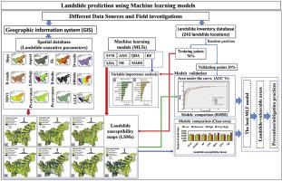
The current study aimed at evaluating the capabilities of seven advanced machine learning techniques (MLTs), including, Support Vector Machine (SVM), Random Forest (RF), Multivariate Adaptive Regression Spline (MARS), Artificial Neural Network (ANN), Quadratic Discriminant Analysis (QDA), Linear Discriminant Analysis (LDA), and Naive Bayes (NB), for landslide susceptibility modeling and comparison of their performances. Coupling machine learning algorithms with spatial data types for landslide susceptibility mapping is a vitally important issue. This study was carried out using GIS and R open source software at Abha Basin, Asir Region, Saudi Arabia. First, a total of 243 landslide locations were identified at Abha Basin to prepare the landslide inventory map using different data sources. All the landslide areas were randomly separated into two groups with a ratio of 70% for training and 30% for validating purposes. Twelve landslide-variables were generated for landslide susceptibility modeling, which include altitude, lithology, distance to faults, normalized difference vegetation index (NDVI), landuse/landcover (LULC), distance to roads, slope angle, distance to streams, profile curvature, plan curvature, slope length (LS), and slope-aspect. The area under curve (AUC-ROC) approach has been applied to evaluate, validate, and compare the MLTs performance. The results indicated that AUC values for seven MLTs range from 89.0% for QDA to 95.1% for RF. Our findings showed that the RF (AUC = 95.1%) and LDA (AUC = 941.7%) have produced the best performances in comparison to other MLTs. The outcome of this study and the landslide susceptibility maps would be useful for environmental protection.
中文翻译:
使用机器学习算法的滑坡敏感性地图绘制及其在沙特阿拉伯阿西尔地区阿卜哈盆地的性能比较
当前的研究旨在评估七种高级机器学习技术(MLT)的功能,包括支持向量机(SVM),随机森林(RF),多元自适应回归样条(MARS),人工神经网络(ANN),二次判别分析(QDA),线性判别分析(LDA)和朴素贝叶斯(NB)用于滑坡敏感性建模和性能比较。将机器学习算法与空间数据类型耦合以进行滑坡敏感性测绘是至关重要的问题。这项研究是使用GIS和R开源软件在沙特阿拉伯Asir地区的Abha盆地进行的。首先,在艾卜哈盆地总共确定了243个滑坡位置,以使用不同的数据源准备滑坡清单图。将所有滑坡区域随机分为两组,用于训练的比例为70%,用于验证目的的比例为30%。生成了十二个滑坡变量用于滑坡敏感性建模,包括高度,岩性,到断层的距离,归一化植被指数(NDVI),土地利用/土地覆被(LULC),到道路的距离,坡度,到溪流的距离,剖面曲率,平面曲率,坡度长度(LS)和坡度纵横比。曲线下面积(AUC-ROC)方法已应用于评估,验证和比较MLT的性能。结果表明,七个MLT的AUC值范围从QDA的89.0%到RF的95.1%。我们的发现表明,与其他MLT相比,RF(AUC = 95.1%)和LDA(AUC = 941.7%)产生了最佳性能。


 京公网安备 11010802027423号