当前位置:
X-MOL 学术
›
J. Asian Earth Sci.
›
论文详情
Our official English website, www.x-mol.net, welcomes your feedback! (Note: you will need to create a separate account there.)
Crustal architecture and isostatic compensation of the Comorin Ridge, Central Indian ocean: implications for the breakup of East Gondwana
Journal of Asian Earth Sciences ( IF 3 ) Pub Date : 2020-09-01 , DOI: 10.1016/j.jseaes.2020.104463 G. Srinivasa Rao , Ashutosh Singh
Journal of Asian Earth Sciences ( IF 3 ) Pub Date : 2020-09-01 , DOI: 10.1016/j.jseaes.2020.104463 G. Srinivasa Rao , Ashutosh Singh
|
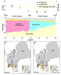
Abstract The Comorin Ridge, located off the southwest margin of Sri Lanka is an important geological feature with significant relevance to understand the breakup of eastern Gondwanaland. Earlier geophysical studies over this ridge provided several contrasting views due to which its origin and nature of emplacement could not be established very well. In this study, an integrated interpretation of bathymetry, gravity, geoid, and ship-borne magnetic data is carried out to bring out a well-constrained evolution model for the ridge. Results of 3-D gravity inversion of Crustal Bouguer anomalies and joint gravity-magnetic modeling indicate that the southern part of the ridge is underlain by 7–12 km thick crust intruded with volcanic rocks and the presence of 13–18 km of anomalously thicker crust below the northern part of the ridge. Further, crustal models, spatial variations in Geoid-Topography Ratio (GTR), and the effective elastic thickness (Te) value obtained in this study suggest a two-stage emplacement model for the evolution of the ridge. The observed lower Te values (7–8 km) in the southern part (0.5°N–3.5°N) and its proximity to the C34ny spreading anomaly suggest its emplacement on the oceanic lithosphere due to Marion plume activity along a fracture zone during ~88–84 Ma. On the other hand, relatively higher Te values (12.5–15 km) in the northern part (3.5°N–6.5°N) with absence seafloor-spreading magnetic anomalies suggests that it could be a marginal basement high formed at the continent-ocean boundary (COB) during the second phase of rifting between India and Sri Lanka (~94 Ma).
中文翻译:

印度洋中部科摩林海脊的地壳结构和均衡补偿:对东冈瓦纳大陆分裂的影响
摘要 位于斯里兰卡西南边缘的科摩林海岭是一个重要的地质特征,对于理解东冈瓦纳大陆的分裂具有重要意义。早期对这条山脊的地球物理研究提供了几种不同的观点,因此无法很好地确定它的起源和就位性质。在这项研究中,对水深测量、重力、大地水准面和船载磁数据进行了综合解释,以提出一个约束良好的山脊演化模型。地壳布格异常的 3-D 重力反演和重磁联合建模结果表明,山脊南部为 7-12 公里厚的地壳,火山岩侵入,存在 13-18 公里厚的异常地壳在山脊的北部下方。更多,地壳模型、大地水准面-地形比 (GTR) 的空间变化以及本研究中获得的有效弹性厚度 (Te) 值表明了山脊演化的两阶段就位模型。在南部(0.5°N-3.5°N)观测到的较低 Te 值(7-8 公里)及其靠近 C34ny 扩展异常表明它在~ 88-84 马。另一方面,北部(3.5°N-6.5°N)相对较高的 Te 值(12.5-15 公里),没有海底扩张磁异常,表明它可能是大陆-海洋形成的边缘基底高印度和斯里兰卡(~94 Ma)裂谷的第二阶段期间的边界(COB)。本研究中获得的有效弹性厚度 (Te) 值表明了山脊演化的两阶段就位模型。在南部(0.5°N-3.5°N)观测到的较低 Te 值(7-8 公里)及其靠近 C34ny 扩展异常表明它在~ 88-84 马。另一方面,北部(3.5°N-6.5°N)相对较高的 Te 值(12.5-15 公里),没有海底扩张磁异常,表明它可能是大陆-海洋形成的边缘基底高印度和斯里兰卡(~94 Ma)裂谷的第二阶段期间的边界(COB)。本研究中获得的有效弹性厚度 (Te) 值表明了山脊演化的两阶段就位模型。在南部(0.5°N-3.5°N)观测到的较低 Te 值(7-8 公里)及其靠近 C34ny 扩展异常表明它在~ 88-84 马。另一方面,北部(3.5°N-6.5°N)相对较高的 Te 值(12.5-15 公里),没有海底扩张磁异常,表明它可能是大陆-海洋形成的边缘基底高印度和斯里兰卡(~94 Ma)裂谷的第二阶段期间的边界(COB)。5°N–3.5°N) 及其与 C34ny 扩展异常的接近程度表明,由于在 ~88–84 Ma 期间沿断裂带的 Marion 羽流活动,它在海洋岩石圈上的侵位。另一方面,北部(3.5°N-6.5°N)相对较高的 Te 值(12.5-15 公里)没有海底扩张磁异常表明它可能是大陆 - 海洋形成的边缘基底高印度和斯里兰卡(~94 Ma)裂谷的第二阶段期间的边界(COB)。5°N–3.5°N) 及其与 C34ny 扩展异常的接近程度表明,由于在 ~88–84 Ma 期间沿断裂带的 Marion 羽流活动,它在海洋岩石圈上的侵位。另一方面,北部(3.5°N-6.5°N)相对较高的 Te 值(12.5-15 公里),没有海底扩张磁异常,表明它可能是大陆-海洋形成的边缘基底高印度和斯里兰卡(~94 Ma)裂谷的第二阶段期间的边界(COB)。
更新日期:2020-09-01
中文翻译:
印度洋中部科摩林海脊的地壳结构和均衡补偿:对东冈瓦纳大陆分裂的影响
摘要 位于斯里兰卡西南边缘的科摩林海岭是一个重要的地质特征,对于理解东冈瓦纳大陆的分裂具有重要意义。早期对这条山脊的地球物理研究提供了几种不同的观点,因此无法很好地确定它的起源和就位性质。在这项研究中,对水深测量、重力、大地水准面和船载磁数据进行了综合解释,以提出一个约束良好的山脊演化模型。地壳布格异常的 3-D 重力反演和重磁联合建模结果表明,山脊南部为 7-12 公里厚的地壳,火山岩侵入,存在 13-18 公里厚的异常地壳在山脊的北部下方。更多,地壳模型、大地水准面-地形比 (GTR) 的空间变化以及本研究中获得的有效弹性厚度 (Te) 值表明了山脊演化的两阶段就位模型。在南部(0.5°N-3.5°N)观测到的较低 Te 值(7-8 公里)及其靠近 C34ny 扩展异常表明它在~ 88-84 马。另一方面,北部(3.5°N-6.5°N)相对较高的 Te 值(12.5-15 公里),没有海底扩张磁异常,表明它可能是大陆-海洋形成的边缘基底高印度和斯里兰卡(~94 Ma)裂谷的第二阶段期间的边界(COB)。本研究中获得的有效弹性厚度 (Te) 值表明了山脊演化的两阶段就位模型。在南部(0.5°N-3.5°N)观测到的较低 Te 值(7-8 公里)及其靠近 C34ny 扩展异常表明它在~ 88-84 马。另一方面,北部(3.5°N-6.5°N)相对较高的 Te 值(12.5-15 公里),没有海底扩张磁异常,表明它可能是大陆-海洋形成的边缘基底高印度和斯里兰卡(~94 Ma)裂谷的第二阶段期间的边界(COB)。本研究中获得的有效弹性厚度 (Te) 值表明了山脊演化的两阶段就位模型。在南部(0.5°N-3.5°N)观测到的较低 Te 值(7-8 公里)及其靠近 C34ny 扩展异常表明它在~ 88-84 马。另一方面,北部(3.5°N-6.5°N)相对较高的 Te 值(12.5-15 公里),没有海底扩张磁异常,表明它可能是大陆-海洋形成的边缘基底高印度和斯里兰卡(~94 Ma)裂谷的第二阶段期间的边界(COB)。5°N–3.5°N) 及其与 C34ny 扩展异常的接近程度表明,由于在 ~88–84 Ma 期间沿断裂带的 Marion 羽流活动,它在海洋岩石圈上的侵位。另一方面,北部(3.5°N-6.5°N)相对较高的 Te 值(12.5-15 公里)没有海底扩张磁异常表明它可能是大陆 - 海洋形成的边缘基底高印度和斯里兰卡(~94 Ma)裂谷的第二阶段期间的边界(COB)。5°N–3.5°N) 及其与 C34ny 扩展异常的接近程度表明,由于在 ~88–84 Ma 期间沿断裂带的 Marion 羽流活动,它在海洋岩石圈上的侵位。另一方面,北部(3.5°N-6.5°N)相对较高的 Te 值(12.5-15 公里),没有海底扩张磁异常,表明它可能是大陆-海洋形成的边缘基底高印度和斯里兰卡(~94 Ma)裂谷的第二阶段期间的边界(COB)。


 京公网安备 11010802027423号