当前位置:
X-MOL 学术
›
J. Afr. Earth Sci.
›
论文详情
Our official English website, www.x-mol.net, welcomes your feedback! (Note: you will need to create a separate account there.)
Stochastic analysis of the groundwater velocity field and implications for contaminant transport within the Ga East and Adentan municipalities, Ghana.
Journal of African Earth Sciences ( IF 2.3 ) Pub Date : 2020-10-01 , DOI: 10.1016/j.jafrearsci.2020.103929 Godfred B. Hagan , Elizabeth Darko
Journal of African Earth Sciences ( IF 2.3 ) Pub Date : 2020-10-01 , DOI: 10.1016/j.jafrearsci.2020.103929 Godfred B. Hagan , Elizabeth Darko
|
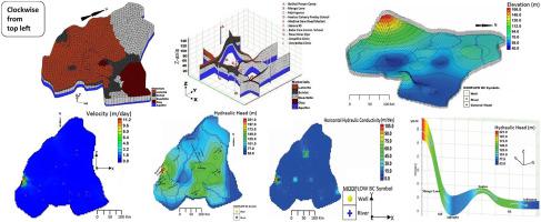
Abstract The hydrogeological systems of the Ga East and Adentan Districts of the Greater Accra Region, Ghana were studied using a numerical model. Historical hydrogeological and groundwater monitoring data on twenty boreholes were used in conceptualising the hydrogeological system. The objective was to estimate the aquifer hydraulic conductivity and recharge, and also simulate the velocity field to assess the impact of contaminant transport within the study area. A steady-state model was developed depicting the groundwater flow conditions of the terrain. A single aquifer system (quartzite-schist formation) has been identified. The aquifer hydraulic conductivity estimates indicate that over 90% of the terrain is lower than 15.0 m day − 1 . The observed outliers are attributable to the fractured and jointed quartzites. The effective aquifer recharge through precipitation for this study ranges between 2.70 × 10 − 5 m day − 1 and 8.10 × 10 − 5 m day − 1 , representing 1.2%–3.6% of the average rainfall records per year in the area. Cases of local and intermediate flow systems, and potential recharge areas were identified. The estimated velocity field ranges from 0.002 to 11.2 m day − 1 , with over 90 % of the area having velocities below 0.85 m day − 1 . The spatial distribution of the velocity field ties in well with the hydraulic conductivity field observed for the terrain. The estimated velocity field makes contamination transport significant in the domain. For instance, contaminants leached into the aquifer zone through recharge by rainfall from the landfill site at Pantang will travel at approximately 0.85 m day − 1 towards Oyarifa, Teiman and Ayimensa communities along an identified flowpath. Seven principal groundwater flowpaths have been identified using the particle tracking technique. The travel times along the flowpaths from recharge to discharge locations ranges from 7 years to 833 years. Stochastic simulations carried out on the calibrated model indicate that the model is unique with respect to the aquifer recharge, hydraulic conductivity and hydraulic head.
中文翻译:

地下水速度场的随机分析以及对加纳 Ga East 和 Adentan 市内污染物迁移的影响。
摘要 使用数值模型研究了加纳大阿克拉地区 Ga East 和 Adentan 地区的水文地质系统。二十个钻孔的历史水文地质和地下水监测数据被用于水文地质系统的概念化。目的是估计含水层的水力传导率和补给量,并模拟速度场以评估研究区域内污染物迁移的影响。开发了一个稳态模型来描述地形的地下水流动条件。已经确定了一个单一的含水层系统(石英岩-片岩地层)。含水层水力传导率估计值表明超过 90% 的地形低于 15.0 m day - 1 。观察到的异常值归因于断裂和节理的石英岩。本研究通过降水的有效含水层补给量介于 2.70 × 10 − 5 m day − 1 和 8.10 × 10 − 5 m day − 1 之间,占该地区每年平均降雨量记录的 1.2%–3.6%。确定了局部和中间流动系统的案例,以及潜在的补给区。估计的速度场范围为 0.002 到 11.2 m day - 1 ,超过 90% 的区域的速度低于 0.85 m day - 1 。速度场的空间分布与观察到的地形水力传导场密切相关。估计的速度场使污染在该域中传输变得重要。例如,通过 Pantang 垃圾填埋场的降雨补给而渗入含水层的污染物将在大约 0.85 m day − 1 处向 Oyarifa 移动,Teiman 和 Ayimensa 社区沿着已确定的流动路径。已经使用粒子追踪技术确定了七个主要的地下水流动路径。沿流路从补给到排放地点的旅行时间从 7 年到 833 年不等。对校准模型进行的随机模拟表明,该模型在含水层补给、导水率和水头方面是独一无二的。
更新日期:2020-10-01
中文翻译:
地下水速度场的随机分析以及对加纳 Ga East 和 Adentan 市内污染物迁移的影响。
摘要 使用数值模型研究了加纳大阿克拉地区 Ga East 和 Adentan 地区的水文地质系统。二十个钻孔的历史水文地质和地下水监测数据被用于水文地质系统的概念化。目的是估计含水层的水力传导率和补给量,并模拟速度场以评估研究区域内污染物迁移的影响。开发了一个稳态模型来描述地形的地下水流动条件。已经确定了一个单一的含水层系统(石英岩-片岩地层)。含水层水力传导率估计值表明超过 90% 的地形低于 15.0 m day - 1 。观察到的异常值归因于断裂和节理的石英岩。本研究通过降水的有效含水层补给量介于 2.70 × 10 − 5 m day − 1 和 8.10 × 10 − 5 m day − 1 之间,占该地区每年平均降雨量记录的 1.2%–3.6%。确定了局部和中间流动系统的案例,以及潜在的补给区。估计的速度场范围为 0.002 到 11.2 m day - 1 ,超过 90% 的区域的速度低于 0.85 m day - 1 。速度场的空间分布与观察到的地形水力传导场密切相关。估计的速度场使污染在该域中传输变得重要。例如,通过 Pantang 垃圾填埋场的降雨补给而渗入含水层的污染物将在大约 0.85 m day − 1 处向 Oyarifa 移动,Teiman 和 Ayimensa 社区沿着已确定的流动路径。已经使用粒子追踪技术确定了七个主要的地下水流动路径。沿流路从补给到排放地点的旅行时间从 7 年到 833 年不等。对校准模型进行的随机模拟表明,该模型在含水层补给、导水率和水头方面是独一无二的。


 京公网安备 11010802027423号