当前位置:
X-MOL 学术
›
Geomorphology
›
论文详情
Our official English website, www.x-mol.net, welcomes your feedback! (Note: you will need to create a separate account there.)
Post-seismic monitoring of cliff mass wasting using an unmanned aerial vehicle and field data at Egremni, Lefkada Island, Greece
Geomorphology ( IF 3.9 ) Pub Date : 2020-10-01 , DOI: 10.1016/j.geomorph.2020.107306 Ioannis Κ. Koukouvelas , Konstantinos G. Nikolakopoulos , Vasiliki Zygouri , Aggeliki Kyriou
Geomorphology ( IF 3.9 ) Pub Date : 2020-10-01 , DOI: 10.1016/j.geomorph.2020.107306 Ioannis Κ. Koukouvelas , Konstantinos G. Nikolakopoulos , Vasiliki Zygouri , Aggeliki Kyriou
|
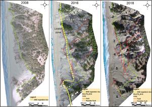
Abstract On 17th November 2015, a strong earthquake affected Lefkada Island, Greece, leading to extensive translational debris slides along the cliff overhanging Egremni beach and the re-activation of previously deposited slope material. The cliff is crossed by the Cephalonia Fault Zone, with mass-wasting processes inducing dry flows occurring in association with long-term tectonic activity. Large-scale co-seismic and post-seismic disturbance of the forest on top of the cliff has also resulted from the seismicity. Three years after the 2015 event, the cliff had retreated due to active translational debris slides and the forest disturbance, which represents a safety concern for the tourist beach below. We aimed to qualitatively assess the transient evolution of debris slides at Egremni and clarify the level of risk posed to the beach below. Annual monitoring was performed between 2015 and 2018 including extensive field measurements and unmanned aerial vehicle (UAV) flight campaigns. Based on the high-resolution images acquired by the UAV, we created orthophoto maps and digital surface models (DSMs) of the cliff using Structure-from-Motion (SfM) photogrammetry. The cliff slope models indicate that the overhanging cliff is progressively entering a stage of decline and approaching equilibrium due to climatic forcing alongside minor seismicity. The DSMs were combined with field survey data to further investigate the role of erosion and deposition across the cliff. Our results indicate that the cliff dynamics at Egremni are primarily controlled by earthquake- and storm-induced debris slides, with rock material moving within the cliff formation via rock falls, and cliff inclination decreasing as a result of primitive slope ‘self-healing’ process. Mass-wasting processes remained widespread across the western part of the Lefkada coast three years after the 2015 earthquake sequence. For safety reasons, we suggest that pre-emptive inspection of the cliffs should be carried annually, after humid and winter periods, and following strong earthquakes using a combination of field surveys and UAV campaigns.
中文翻译:

使用无人机和现场数据在希腊莱夫卡达岛埃格雷姆尼对悬崖质量浪费进行地震后监测
摘要 2015 年 11 月 17 日,希腊莱夫卡达岛发生强烈地震,导致埃格雷姆尼海滩悬崖沿线大面积平移碎片滑坡,先前沉积的斜坡物质重新活化。悬崖被 Cephalonia 断层带穿过,质量消耗过程导致与长期构造活动相关的干流。崖顶森林的大规模同震和震后扰动也是地震活动的结果。2015 年事件发生三年后,由于活跃的平移碎片滑坡和森林干扰,悬崖已经后退,这对下面的旅游海滩构成了安全问题。我们旨在定性评估 Egremni 泥石流的瞬态演变,并阐明对下方海滩构成的风险水平。2015 年至 2018 年期间进行了年度监测,包括广泛的现场测量和无人机 (UAV) 飞行活动。基于 UAV 获取的高分辨率图像,我们使用结构-运动 (SfM) 摄影测量法创建了悬崖的正射影像图和数字表面模型 (DSM)。悬崖边坡模型表明,由于气候强迫和小地震活动,悬垂悬崖逐渐进入下降并接近平衡阶段。DSM 与实地调查数据相结合,以进一步调查悬崖上的侵蚀和沉积作用。我们的结果表明,埃格雷姆尼的悬崖动力学主要受地震和风暴引起的泥石流控制,岩石物质通过岩石坠落在悬崖地层内移动,原始坡度“自愈”过程导致悬崖倾斜度下降。在 2015 年地震序列发生三年后,莱夫卡斯州海岸的西部地区仍然普遍存在物质消耗过程。出于安全原因,我们建议每年在潮湿和冬季之后以及在强烈地震之后结合实地调查和无人机活动对悬崖进行预先检查。
更新日期:2020-10-01
中文翻译:
使用无人机和现场数据在希腊莱夫卡达岛埃格雷姆尼对悬崖质量浪费进行地震后监测
摘要 2015 年 11 月 17 日,希腊莱夫卡达岛发生强烈地震,导致埃格雷姆尼海滩悬崖沿线大面积平移碎片滑坡,先前沉积的斜坡物质重新活化。悬崖被 Cephalonia 断层带穿过,质量消耗过程导致与长期构造活动相关的干流。崖顶森林的大规模同震和震后扰动也是地震活动的结果。2015 年事件发生三年后,由于活跃的平移碎片滑坡和森林干扰,悬崖已经后退,这对下面的旅游海滩构成了安全问题。我们旨在定性评估 Egremni 泥石流的瞬态演变,并阐明对下方海滩构成的风险水平。2015 年至 2018 年期间进行了年度监测,包括广泛的现场测量和无人机 (UAV) 飞行活动。基于 UAV 获取的高分辨率图像,我们使用结构-运动 (SfM) 摄影测量法创建了悬崖的正射影像图和数字表面模型 (DSM)。悬崖边坡模型表明,由于气候强迫和小地震活动,悬垂悬崖逐渐进入下降并接近平衡阶段。DSM 与实地调查数据相结合,以进一步调查悬崖上的侵蚀和沉积作用。我们的结果表明,埃格雷姆尼的悬崖动力学主要受地震和风暴引起的泥石流控制,岩石物质通过岩石坠落在悬崖地层内移动,原始坡度“自愈”过程导致悬崖倾斜度下降。在 2015 年地震序列发生三年后,莱夫卡斯州海岸的西部地区仍然普遍存在物质消耗过程。出于安全原因,我们建议每年在潮湿和冬季之后以及在强烈地震之后结合实地调查和无人机活动对悬崖进行预先检查。


 京公网安备 11010802027423号