当前位置:
X-MOL 学术
›
J. Afr. Earth Sci.
›
论文详情
Our official English website, www.x-mol.net, welcomes your
feedback! (Note: you will need to create a separate account there.)
Lithological and alteration mineral mapping for alluvial gold exploration in the south east of Birao area, Central African Republic using Landsat-8 Operational Land Imager (OLI) data
Journal of African Earth Sciences ( IF 2.2 ) Pub Date : 2020-10-01 , DOI: 10.1016/j.jafrearsci.2020.103933 Mamadou Traore , Jonas Didero Takodjou Wambo , Cyrille Prosper Ndepete , Senem Tekin , Amin Beiranvand Pour , Aidy M. Muslim
Journal of African Earth Sciences ( IF 2.2 ) Pub Date : 2020-10-01 , DOI: 10.1016/j.jafrearsci.2020.103933 Mamadou Traore , Jonas Didero Takodjou Wambo , Cyrille Prosper Ndepete , Senem Tekin , Amin Beiranvand Pour , Aidy M. Muslim
|
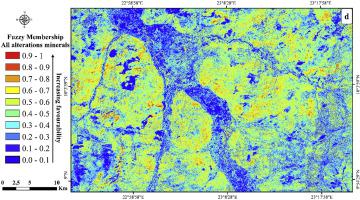
Abstract Geological field mapping and mineral exploration still remain very laborious in many parts of the inter tropical regions of African plate due to remoteness, low security and high cost. Currently, a number of remote sensing satellite imagery are freely available and can be broadly used for lithological mapping and mineral exploration in inaccessible regions of African plate. The Birao region of the Central African Republic is well known for its alluvial deposits of gold and copper. The Birao region is located in subtropical belt of Africa plate. In this study, Landsat-8 Operational Land Imager (OLI) satellite imagery was used for lithological and alteration mapping in the south-eastern part (inaccessible zone) of Birao region for alluvial gold exploration. Image processing techniques such as False Color Composite (FCC), Band Ratio (BR), Principal component analysis (PCA), minimum noise fraction (MNF) and Spectral Angle Mapper (SAM) were executed to extract spectral information related to lithological units and alteration minerals. Clay and carbonate minerals, iron oxides, ferrous silicates and lithological units, including the Neo-Chadian Formation, the Lower Proterozoic Formations and the Recent Alluvial Formation were identified and discriminated in the study area. The band ratio of 6/7, 4/2 and 6/5 were typically used to map clay, iron oxides and ferrous silicates, respectively. The results of band ratio and PCA techniques were integrated with fuzzy logic modeling that considerably highlighted hydrothermal alteration minerals and high perspective zones for alluvial gold exploration. Additionally, an updated lithological-mineralogical map was generated for south-eastern part of the Birao region by fusing the FCC, MNF and SAM techniques. Comparison with previous lithological map of the study area, virtual verification, fieldwork and laboratory data confirmed good rate of accuracy for the result obtained from the Landsat-8 OLI satellite data. The approach presented in this study is a low-cost technique that highly applicable for lithological mapping and mineral exploration in remote subtropical regions of African plate.
中文翻译:

使用 Landsat-8 操作陆地成像仪 (OLI) 数据对中非共和国比劳地区东南部冲积金勘探进行岩性和蚀变矿物测绘
摘要 由于地处偏远、安全性低、成本高,在非洲板块热带间地区的许多地区,地质野外测绘和矿产勘探仍然十分繁重。目前,一些遥感卫星图像可以免费获取,可广泛用于非洲板块难以进入地区的岩性测绘和矿产勘探。中非共和国的比劳地区以其金和铜的冲积矿床而闻名。比劳地区位于非洲板块的亚热带带。在这项研究中,Landsat-8 Operational Land Imager (OLI) 卫星图像用于在比劳地区东南部(难以到达的区域)进行岩性和蚀变绘图,以进行冲积金勘探。图像处理技术,如伪彩色合成 (FCC)、带比 (BR)、执行主成分分析 (PCA)、最小噪声分数 (MNF) 和光谱角度映射器 (SAM) 以提取与岩性单元和蚀变矿物相关的光谱信息。粘土和碳酸盐矿物、氧化铁、硅酸亚铁和岩性单元,包括新乍得组、下元古代组和新冲积组在研究区被识别和区分。6/7、4/2 和 6/5 的谱带比通常分别用于绘制粘土、氧化铁和硅酸亚铁。带比和 PCA 技术的结果与模糊逻辑模型相结合,大大突出了热液蚀变矿物和冲积金勘探的高透视区。此外,通过融合 FCC、MNF 和 SAM 技术,为比劳地区东南部生成了更新的岩性-矿物学图。与先前研究区岩性图的比较、虚拟验证、实地工作和实验室数据证实了从 Landsat-8 OLI 卫星数据获得的结果的良好准确率。本研究中提出的方法是一种低成本技术,非常适用于非洲板块偏远亚热带地区的岩性测绘和矿产勘探。
更新日期:2020-10-01
中文翻译:
使用 Landsat-8 操作陆地成像仪 (OLI) 数据对中非共和国比劳地区东南部冲积金勘探进行岩性和蚀变矿物测绘
摘要 由于地处偏远、安全性低、成本高,在非洲板块热带间地区的许多地区,地质野外测绘和矿产勘探仍然十分繁重。目前,一些遥感卫星图像可以免费获取,可广泛用于非洲板块难以进入地区的岩性测绘和矿产勘探。中非共和国的比劳地区以其金和铜的冲积矿床而闻名。比劳地区位于非洲板块的亚热带带。在这项研究中,Landsat-8 Operational Land Imager (OLI) 卫星图像用于在比劳地区东南部(难以到达的区域)进行岩性和蚀变绘图,以进行冲积金勘探。图像处理技术,如伪彩色合成 (FCC)、带比 (BR)、执行主成分分析 (PCA)、最小噪声分数 (MNF) 和光谱角度映射器 (SAM) 以提取与岩性单元和蚀变矿物相关的光谱信息。粘土和碳酸盐矿物、氧化铁、硅酸亚铁和岩性单元,包括新乍得组、下元古代组和新冲积组在研究区被识别和区分。6/7、4/2 和 6/5 的谱带比通常分别用于绘制粘土、氧化铁和硅酸亚铁。带比和 PCA 技术的结果与模糊逻辑模型相结合,大大突出了热液蚀变矿物和冲积金勘探的高透视区。此外,通过融合 FCC、MNF 和 SAM 技术,为比劳地区东南部生成了更新的岩性-矿物学图。与先前研究区岩性图的比较、虚拟验证、实地工作和实验室数据证实了从 Landsat-8 OLI 卫星数据获得的结果的良好准确率。本研究中提出的方法是一种低成本技术,非常适用于非洲板块偏远亚热带地区的岩性测绘和矿产勘探。


 京公网安备 11010802027423号