当前位置:
X-MOL 学术
›
Earth Surf.Process. Land.
›
论文详情
Our official English website, www.x-mol.net, welcomes your
feedback! (Note: you will need to create a separate account there.)
Measuring channel planform change from image time series: A generalizable, spatially distributed, probabilistic method for quantifying uncertainty
Earth Surface Processes and Landforms ( IF 2.8 ) Pub Date : 2020-07-07 , DOI: 10.1002/esp.4926 Christina M. Leonard 1 , Carl J. Legleiter 2 , Devin M. Lea 3 , John C. Schmidt 1
Earth Surface Processes and Landforms ( IF 2.8 ) Pub Date : 2020-07-07 , DOI: 10.1002/esp.4926 Christina M. Leonard 1 , Carl J. Legleiter 2 , Devin M. Lea 3 , John C. Schmidt 1
Affiliation
|
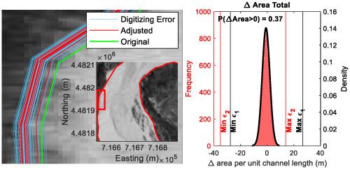
Channels change in response to natural or anthropogenic fluctuations in streamflow and/or sediment supply and measurements of channel change are critical to many river management applications. Whereas repeated field surveys are costly and time‐consuming, remote sensing can be used to detect channel change at multiple temporal and spatial scales. Repeat images have been widely used to measure long‐term channel change, but these measurements are only significant if the magnitude of change exceeds the uncertainty. Existing methods for characterizing uncertainty have two important limitations. First, while the use of a spatially variable image co‐registration error avoids the assumption that errors are spatially uniform, this type of error, as originally formulated, can only be applied to linear channel adjustments, which provide less information on channel change than polygons of erosion and deposition. Second, previous methods use a level‐of‐detection (LoD) threshold to remove non‐significant measurements, which is problematic because real changes that occurred but were smaller than the LoD threshold would be removed. In this study, we present a new method of quantifying uncertainty associated with channel change based on probabilistic, spatially varying estimates of co‐registration error and digitization uncertainty that obviates a LoD threshold. The spatially distributed probabilistic (SDP) method can be applied to both linear channel adjustments and polygons of erosion and deposition, making this the first uncertainty method generalizable to all metrics of channel change. Using a case study from the Yampa River, Colorado, we show that the SDP method reduced the magnitude of uncertainty and enabled us to detect smaller channel changes as significant. Additionally, the distributional information provided by the SDP method allowed us to report the magnitude of channel change with an appropriate level of confidence in cases where a simple LoD approach yielded an indeterminate result. © 2020 John Wiley & Sons, Ltd.
中文翻译:

测量图像时间序列中通道平面形式的变化:一种用于量化不确定性的可概括的,空间分布的概率方法
河道响应于水流和/或沉积物供应的自然或人为波动而变化,而河道变化的测量对于许多河流管理应用至关重要。重复进行实地调查不仅成本高昂而且费时,但是可以使用遥感技术来检测多个时空尺度上的频道变化。重复图像已被广泛用于测量长期信道变化,但是这些测量仅在变化幅度超过不确定性时才有意义。表征不确定性的现有方法有两个重要局限性。首先,尽管使用空间可变的图像共配准误差避免了误差在空间上是均匀的假设,但这种误差,如最初提出的那样,只能应用于线性通道调整,与侵蚀和沉积的多边形相比,它们提供的有关渠道变化的信息更少。其次,以前的方法使用检测水平(LoD)阈值来删除不重要的测量值,这是有问题的,因为将发生的实际变化小于LoD阈值,因此会被删除。在这项研究中,我们提出了一种新的量化信道变化相关不确定性的方法,该方法基于概率,空间变化的共注册误差和数字化不确定性的估计值,从而避免了LoD阈值。空间分布概率(SDP)方法既可以应用于线性通道调整,也可以应用于侵蚀和沉积的多边形,这是第一个可以推广到所有通道变化度量的不确定性方法。以科罗拉多州扬帕河为例,我们表明,SDP方法降低了不确定性的幅度,并使我们能够检测到较小的信道变化,这是很重要的。此外,在简单的LoD方法产生不确定结果的情况下,SDP方法提供的分布信息使我们能够以适当的置信度报告信道变化的幅度。分级为4 +©2020 John Wiley&Sons,Ltd.
更新日期:2020-07-07
中文翻译:
测量图像时间序列中通道平面形式的变化:一种用于量化不确定性的可概括的,空间分布的概率方法
河道响应于水流和/或沉积物供应的自然或人为波动而变化,而河道变化的测量对于许多河流管理应用至关重要。重复进行实地调查不仅成本高昂而且费时,但是可以使用遥感技术来检测多个时空尺度上的频道变化。重复图像已被广泛用于测量长期信道变化,但是这些测量仅在变化幅度超过不确定性时才有意义。表征不确定性的现有方法有两个重要局限性。首先,尽管使用空间可变的图像共配准误差避免了误差在空间上是均匀的假设,但这种误差,如最初提出的那样,只能应用于线性通道调整,与侵蚀和沉积的多边形相比,它们提供的有关渠道变化的信息更少。其次,以前的方法使用检测水平(LoD)阈值来删除不重要的测量值,这是有问题的,因为将发生的实际变化小于LoD阈值,因此会被删除。在这项研究中,我们提出了一种新的量化信道变化相关不确定性的方法,该方法基于概率,空间变化的共注册误差和数字化不确定性的估计值,从而避免了LoD阈值。空间分布概率(SDP)方法既可以应用于线性通道调整,也可以应用于侵蚀和沉积的多边形,这是第一个可以推广到所有通道变化度量的不确定性方法。以科罗拉多州扬帕河为例,我们表明,SDP方法降低了不确定性的幅度,并使我们能够检测到较小的信道变化,这是很重要的。此外,在简单的LoD方法产生不确定结果的情况下,SDP方法提供的分布信息使我们能够以适当的置信度报告信道变化的幅度。分级为4 +©2020 John Wiley&Sons,Ltd.


 京公网安备 11010802027423号