当前位置:
X-MOL 学术
›
Ocean Coast Manage.
›
论文详情
Our official English website, www.x-mol.net, welcomes your
feedback! (Note: you will need to create a separate account there.)
Seascape metrics, spatio-temporal change, and intensity of use for the spatial conservation prioritization of a Caribbean marine protected area
Ocean & Coastal Management ( IF 4.8 ) Pub Date : 2020-08-01 , DOI: 10.1016/j.ocecoaman.2020.105265 Angela Karina Ortiz Cajica , Gustavo Hinojosa-Arango , Joaquín Rodrigo Garza-Pérez , Rodolfo Rioja-Nieto
Ocean & Coastal Management ( IF 4.8 ) Pub Date : 2020-08-01 , DOI: 10.1016/j.ocecoaman.2020.105265 Angela Karina Ortiz Cajica , Gustavo Hinojosa-Arango , Joaquín Rodrigo Garza-Pérez , Rodolfo Rioja-Nieto
|
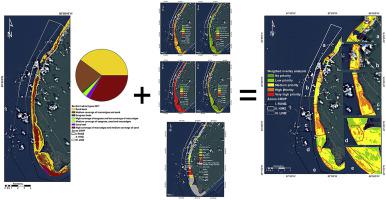
Abstract An effective management tool for the spatial prioritization of the Cozumel Reefs National Park (CRNP), using a systematic approach, is an urgent need for the conservation of one of the most important Marine Protected Areas (MPAs) in Mexico. In this study, we integrated a model using seascape metrics, the spatio-temporal variation of substrate coverage, and frequency of reef use for SCUBA diving, to systematically identify priority areas for conservation within the CRNP. We identified seven habitat types: sand beds, reef, two habitats of macroalgae beds (high and low cover), and seagrass beds with three different densities, using a supervised classification on a SPOT 7 (2017) satellite image (overall accuracy of 84%, Kappa of 0.79). Matlab and Fragstats were used to calculate seascape metrics (habitat β-diversity, shape complexity and connectivity). A change detection analysis, comparing the SPOT 7 with an Ikonos image, was utilized to estimate seascape change between 2004 and 2017. Interviews with diving operators were also obtained, to calculate the frequency of visits to different reefs within the CRNP. A weighted overlay analysis, integrating the metrics mentioned above, was used to identify priority areas for conservation. We identified five areas, where management strategies need to be strengthened (e.g. limiting the number of visitors). The current subzonation of the protected area does not reflect the conservation priorities identified by our analysis. However, given that the CRNP management plan is in the process of being updated, the obtained results can help the CRNP managers improve the conservation efforts based on a systematic and robust approach, ensuring the design and implementation of cost-effective strategies for the conservation of the MPA.
中文翻译:

加勒比海洋保护区空间保护优先排序的海景指标、时空变化和使用强度
摘要 使用系统方法对科苏梅尔珊瑚礁国家公园 (CRNP) 进行空间优先排序的有效管理工具是保护墨西哥最重要的海洋保护区 (MPA) 之一的迫切需要。在这项研究中,我们整合了一个使用海景指标、基质覆盖的时空变化以及水肺潜水使用珊瑚礁的频率的模型,以系统地确定 CRNP 内的优先保护区域。我们在 SPOT 7 (2017) 卫星图像上使用监督分类确定了七种栖息地类型:沙床、礁石、两种大型藻类床栖息地(高覆盖和低覆盖)以及三种不同密度的海草床(总体准确率 84%) ,Kappa 为 0.79)。Matlab 和 Fragstats 用于计算海景指标(栖息地 β-多样性、形状复杂性和连通性)。变化检测分析,将 SPOT 7 与 Ikonos 图像进行比较,用于估计 2004 年至 2017 年间的海景变化。还获得了对潜水操作员的采访,以计算访问 CRNP 内不同珊瑚礁的频率。综合上述指标的加权叠加分析被用于确定优先保护领域。我们确定了五个需要加强管理策略的领域(例如限制访客数量)。目前保护区的分区没有反映我们分析确定的保护优先事项。然而,鉴于 CRNP 管理计划正在更新中,
更新日期:2020-08-01
中文翻译:
加勒比海洋保护区空间保护优先排序的海景指标、时空变化和使用强度
摘要 使用系统方法对科苏梅尔珊瑚礁国家公园 (CRNP) 进行空间优先排序的有效管理工具是保护墨西哥最重要的海洋保护区 (MPA) 之一的迫切需要。在这项研究中,我们整合了一个使用海景指标、基质覆盖的时空变化以及水肺潜水使用珊瑚礁的频率的模型,以系统地确定 CRNP 内的优先保护区域。我们在 SPOT 7 (2017) 卫星图像上使用监督分类确定了七种栖息地类型:沙床、礁石、两种大型藻类床栖息地(高覆盖和低覆盖)以及三种不同密度的海草床(总体准确率 84%) ,Kappa 为 0.79)。Matlab 和 Fragstats 用于计算海景指标(栖息地 β-多样性、形状复杂性和连通性)。变化检测分析,将 SPOT 7 与 Ikonos 图像进行比较,用于估计 2004 年至 2017 年间的海景变化。还获得了对潜水操作员的采访,以计算访问 CRNP 内不同珊瑚礁的频率。综合上述指标的加权叠加分析被用于确定优先保护领域。我们确定了五个需要加强管理策略的领域(例如限制访客数量)。目前保护区的分区没有反映我们分析确定的保护优先事项。然而,鉴于 CRNP 管理计划正在更新中,


 京公网安备 11010802027423号