Catena ( IF 5.4 ) Pub Date : 2020-06-05 , DOI: 10.1016/j.catena.2020.104681 Indrani Mukherjee , Umesh Kumar Singh
|
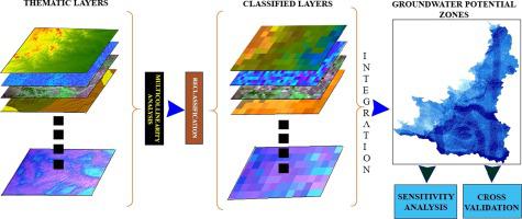
Over-extraction of groundwater has compromised its climatic resilience properties and the arid/semi-arid rural tracts are becoming increasingly vulnerable to the risks of groundwater scarcity. This study has employed a combination of Geographical Information System (GIS) and Analytical Hierarchical Process (AHP) techniques to delineate the Groundwater Potential Zones (GPZs) of the semi-arid Birbhum district in eastern India which suffers from seasonal drought during lean periods. For a reliable evaluation, a large number of thematic layers (N = 12) including geology, geomorphology, Land Use/Land Cover (LULC), fault and lineament density, drainage density, rainfall, soil type, slope, roughness, topographic wetness index, topographic position index and curvature were considered for this assessment. Multicollinearity and consistency checks were performed prior integrating the layers to avoid a non-trivial degree of accuracy in prediction output. The GPZ map was obtained with an accuracy of 80.49% with respect to the observation tube well data. Based on the obtained output, 38.24%, 24.24% and 11.14% of areas of the district classified as moderate, poor, and very poor GPZs, respectively, whereas only 26.38% of the district classified as high to very high GPZs. Cross-validation using the Receiver Operating Characteristic curve revealed a good prediction accuracy of 71.50%. Furthermore, map removal and single parameter sensitivity analysis was also performed which revealed geology, geomorphology, soil types, rainfall, LULC and lineament density as the most influential parameters for the prediction model where exclusion of any thematic layer significantly changes the prediction accuracy and area of each GPZ class. The most convincing GPZs are recorded in some parts of the Mayurakshi and Ajay river basins and certain alluvial aquifer regions. Nonetheless, the study recommends the adaptation of Managed Aquifer Recharge techniques including rainwater harvesting, alternative cropping patterns and irrigation techniques such as sprinklers, drips and micro irrigations to increase the groundwater potential of the water crisis zones.
中文翻译:
使用GIS和层次分析法划分印度东部干旱半干旱地区的地下水潜在区。
地下水的过度开采已经损害了其气候适应能力,而干旱/半干旱的农村地区正变得越来越容易受到地下水短缺风险的影响。这项研究结合了地理信息系统(GIS)和层次分析法(AHP)技术来描绘印度东部半干旱Birbhum地区的地下水潜在地带(GPZs),该地区在贫瘠时期遭受季节性干旱。为了进行可靠的评估,需要包含大量主题层(N = 12),包括地质,地貌,土地利用/土地覆被(LULC),断层和沿线密度,排水密度,降雨,土壤类型,坡度,粗糙度,地形湿度指数,地形位置指数和曲率被考虑用于该评估。在整合图层之前执行多重共线性和一致性检查,以避免在预测输出中达到不平凡的准确性。获得的GPZ图相对于观察管井数据的准确度为80.49%。根据获得的产出,该地区分别有38.24%,24.24%和11.14%划分为中度,贫困和非常贫困的GPZ,而只有26.38%的区域被划分为高至非常高的GPZ。使用接收器工作特性曲线的交叉验证显示出71.50%的良好预测准确性。此外,还进行了地图删除和单参数敏感性分析,揭示了地质,地貌,土壤类型,降雨,LULC和线条密度是预测模型中最有影响力的参数,其中排除任何专题图层都会显着改变每个GPZ类的预测精度和面积。在Mayurakshi和Ajay河流域的某些地区以及某些冲积含水层地区记录了最有说服力的GPZ。尽管如此,该研究建议采用有管理的含水层补给技术,包括雨水收集,替代作物种植方式和喷灌,滴灌和微灌等灌溉技术,以增加水危机地区的地下水潜力。


 京公网安备 11010802027423号