当前位置:
X-MOL 学术
›
Hydrol. Process.
›
论文详情
Our official English website, www.x-mol.net, welcomes your
feedback! (Note: you will need to create a separate account there.)
Headwaters drive streamflow and lowland tracer export in a large‐scale humid tropical catchment
Hydrological Processes ( IF 2.8 ) Pub Date : 2020-07-09 , DOI: 10.1002/hyp.13841 Christian Birkel 1, 2 , Alicia Correa‐Barahona 1 , Marco Martinez‐Martinez 1 , Sebastian Granados‐Bolaños 1 , Nelson Venegas‐Cordero 1 , Kenneth Gutiérrez‐García 1 , Sara Blanco‐Ramírez 1 , Rafael Quesada‐Mora 1 , Vanessa Solano‐Rivera 1 , Jasson Mussio‐Mora 1 , Andres Chavarría‐Palma 1 , Katherine Vargas‐Arias 1 , Georgianne W. Moore 3 , Ana Maria Durán‐Quesada 4 , Javier Vasquez‐Morera 5 , Chris Soulsby 2 , Dörthe Tetzlaff 2, 6, 7 , Edgar Espinoza‐Cisneros 1 , Ricardo Sánchez‐Murillo 8
Hydrological Processes ( IF 2.8 ) Pub Date : 2020-07-09 , DOI: 10.1002/hyp.13841 Christian Birkel 1, 2 , Alicia Correa‐Barahona 1 , Marco Martinez‐Martinez 1 , Sebastian Granados‐Bolaños 1 , Nelson Venegas‐Cordero 1 , Kenneth Gutiérrez‐García 1 , Sara Blanco‐Ramírez 1 , Rafael Quesada‐Mora 1 , Vanessa Solano‐Rivera 1 , Jasson Mussio‐Mora 1 , Andres Chavarría‐Palma 1 , Katherine Vargas‐Arias 1 , Georgianne W. Moore 3 , Ana Maria Durán‐Quesada 4 , Javier Vasquez‐Morera 5 , Chris Soulsby 2 , Dörthe Tetzlaff 2, 6, 7 , Edgar Espinoza‐Cisneros 1 , Ricardo Sánchez‐Murillo 8
Affiliation
|
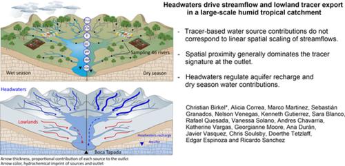
Headwaters are generally assumed to contribute the majority of water to downstream users, but how much water, of what quality and where it is generated are rarely known in the humid tropics. Here, using monthly monitoring in the data scarce (2,370 km2) San Carlos catchment in northeastern Costa Rica, we determined runoff‐area relationships linked to geochemical and isotope tracers. We established 46 monitoring sites covering the full range of climatic, land use and geological gradients in the catchment. Regression and cluster analysis revealed unique spatial patterns and hydrologically functional landscape units. These units were used for seasonal and annual Bayesian tracer mixing models to assess spatial water source contributions to the outlet. Generally, the Bayesian mixing analysis showed that the chemical and isotopic imprint at the outlet is throughout the year dominated by the adjacent lowland catchments (68%) with much less tracer influence from the headwaters. However, the headwater catchments contributed the bulk of water and tracers to the outlet during the dry season (>50%) despite covering less than half of the total catchment area. Additionally, flow volumes seemed to be linearly scaled by area maintaining a link between the headwaters and the outlet particularly during high flows of the rainy season. Stable isotopes indicated mean recharge elevations above the mean catchment altitude, which further supports that headwaters were the primary source of downstream water. Our spatially detailed “snap‐shot” sampling enabled a viable alternative source of large‐scale hydrological process knowledge in the humid tropics with limited data availability.
中文翻译:

在大规模潮湿的热带流域,上游源头驱动水流和低地示踪剂出口
一般认为上游水源将大部分水贡献给下游用户,但是在潮湿的热带地区很少知道多少水,什么质量的水以及在哪里产生。在这里,对数据稀缺(2,370 km 2)哥斯达黎加东北部的圣卡洛斯流域,我们确定了与地球化学和同位素示踪剂相关的径流面积关系。我们在流域建立了46个监测点,涵盖了整个气候,土地利用和地质梯度。回归和聚类分析揭示了独特的空间格局和水文功能性景观单位。这些单位用于季节性和年度贝叶斯示踪剂混合模型,以评估空间水源对出口的贡献。通常,贝叶斯混合分析表明,出口处的化学和同位素痕迹全年都由邻近的低地流域(68%)控制,而源头对示踪剂的影响要小得多。然而,在干旱季节,源头集水区贡献了大部分的水和示踪剂(> 50%),尽管覆盖不到集水区总面积的一半。此外,流量似乎是按面积线性缩放的,尤其是在雨季的高流量期间,维持源头和出口之间的联系。稳定的同位素表明平均补给高度高于平均集水高度,这进一步支持了源头水是下游水的主要来源。我们在空间上详细的“快照”采样为潮湿热带地区提供了可行的大规模水文过程知识的替代来源,而数据可用性有限。稳定的同位素表明平均补给高度高于平均集水高度,这进一步支持了源头水是下游水的主要来源。我们在空间上详细的“快照”采样为潮湿热带地区提供了可行的大规模水文过程知识的替代来源,而数据可用性有限。稳定的同位素表明平均补给高度高于平均集水高度,这进一步支持了源头水是下游水的主要来源。我们在空间上详细的“快照”采样为潮湿热带地区提供了可行的大规模水文过程知识的替代来源,而数据可用性有限。
更新日期:2020-07-09
中文翻译:
在大规模潮湿的热带流域,上游源头驱动水流和低地示踪剂出口
一般认为上游水源将大部分水贡献给下游用户,但是在潮湿的热带地区很少知道多少水,什么质量的水以及在哪里产生。在这里,对数据稀缺(2,370 km 2)哥斯达黎加东北部的圣卡洛斯流域,我们确定了与地球化学和同位素示踪剂相关的径流面积关系。我们在流域建立了46个监测点,涵盖了整个气候,土地利用和地质梯度。回归和聚类分析揭示了独特的空间格局和水文功能性景观单位。这些单位用于季节性和年度贝叶斯示踪剂混合模型,以评估空间水源对出口的贡献。通常,贝叶斯混合分析表明,出口处的化学和同位素痕迹全年都由邻近的低地流域(68%)控制,而源头对示踪剂的影响要小得多。然而,在干旱季节,源头集水区贡献了大部分的水和示踪剂(> 50%),尽管覆盖不到集水区总面积的一半。此外,流量似乎是按面积线性缩放的,尤其是在雨季的高流量期间,维持源头和出口之间的联系。稳定的同位素表明平均补给高度高于平均集水高度,这进一步支持了源头水是下游水的主要来源。我们在空间上详细的“快照”采样为潮湿热带地区提供了可行的大规模水文过程知识的替代来源,而数据可用性有限。稳定的同位素表明平均补给高度高于平均集水高度,这进一步支持了源头水是下游水的主要来源。我们在空间上详细的“快照”采样为潮湿热带地区提供了可行的大规模水文过程知识的替代来源,而数据可用性有限。稳定的同位素表明平均补给高度高于平均集水高度,这进一步支持了源头水是下游水的主要来源。我们在空间上详细的“快照”采样为潮湿热带地区提供了可行的大规模水文过程知识的替代来源,而数据可用性有限。


 京公网安备 11010802027423号