当前位置:
X-MOL 学术
›
Environ. Sci. Technol.
›
论文详情
Our official English website, www.x-mol.net, welcomes your
feedback! (Note: you will need to create a separate account there.)
Estimation of High-Resolution PM2.5 over the Indo-Gangetic Plain by Fusion of Satellite Data, Meteorology, and Land Use Variables.
Environmental Science & Technology ( IF 10.8 ) Pub Date : 2020-06-03 , DOI: 10.1021/acs.est.0c01769 Alaa Mhawish 1, 2, 3 , Tirthankar Banerjee 3, 4 , Meytar Sorek-Hamer 1, 2 , Muhammad Bilal 5 , Alexei I Lyapustin 6 , Robert Chatfield 2 , David M Broday 7
Environmental Science & Technology ( IF 10.8 ) Pub Date : 2020-06-03 , DOI: 10.1021/acs.est.0c01769 Alaa Mhawish 1, 2, 3 , Tirthankar Banerjee 3, 4 , Meytar Sorek-Hamer 1, 2 , Muhammad Bilal 5 , Alexei I Lyapustin 6 , Robert Chatfield 2 , David M Broday 7
Affiliation
|
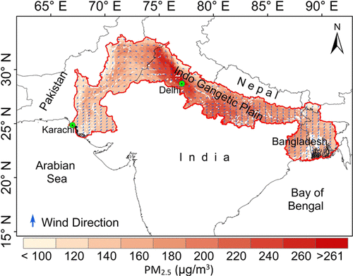
Very high spatially resolved satellite-derived ground-level concentrations of particulate matter with an aerodynamic diameter of less than 2.5 μm (PM2.5) have multiple potential applications, especially in air quality modeling and epidemiological and climatological research. Satellite-derived aerosol optical depth (AOD) and columnar water vapor (CWV), meteorological parameters, and land use data were used as variables within the framework of a linear mixed effect model (LME) and a random forest (RF) model to predict daily ground-level concentrations of PM2.5 at 1 km × 1 km grid resolution across the Indo-Gangetic Plain (IGP) in South Asia. The RF model exhibited superior performance and higher accuracy compared with the LME model, with better cross-validated explained variance (R2 = 0.87) and lower relative prediction error (RPE = 24.5%). The RF model revealed improved performance metrics for increasing averaging periods, from daily to weekly, monthly, seasonal, and annual means, which supported its use in estimating PM2.5 exposure metrics across the IGP at varying temporal scales (i.e., both short and long terms). The RF-based PM2.5 estimates showed high PM2.5 levels over the middle and lower IGP, with the annual mean exceeding 110 μg/m3. As for seasons, winter was the most polluted season, while monsoon was the cleanest. Spatially, the middle and lower IGP showed poorer air quality compared to the upper IGP. In winter, the middle and lower IGP experienced very poor air quality, with mean PM2.5 concentrations of >170 μg/m3.
中文翻译:

通过卫星数据,气象学和土地利用变量的融合估算印度恒河平原的高分辨率PM2.5。
空气动力学直径小于2.5μm(PM 2.5)的极高空间分辨的卫星衍生地面浓度微粒具有多种潜在应用,尤其是在空气质量建模以及流行病学和气候学研究中。在线性混合效应模型(LME)和随机森林(RF)模型的框架内,将卫星衍生的气溶胶光学深度(AOD)和柱状水蒸气(CWV),气象参数和土地利用数据用作变量整个南亚印度恒河平原(IGP)的1 km×1 km网格分辨率下,PM 2.5的每日地面水平浓度。与LME模型相比,RF模型表现出更高的性能和更高的准确性,并且具有更好的交叉验证的解释方差(R 2 = 0.87)和较低的相对预测误差(RPE = 24.5%)。RF模型揭示了改进的性能指标,可以延长平均时间,从每天到每周,每月,季节性和年度平均值,这支持它用于估算不同时间范围(即短期和长期)的整个IGP的PM 2.5暴露指标。 )。基于RF的PM 2.5估计值表明,IGP中值和下值的PM 2.5较高,年均值超过110μg/ m 3。至于季节,冬天是污染最严重的季节,而季风是最干净的季节。在空间上,与上IGP相比,中下IGP的空气质量较差。在冬季,中下IGP的空气质量非常差,PM 2.5的平均浓度> 170μg/ m 3。
更新日期:2020-07-07
中文翻译:
通过卫星数据,气象学和土地利用变量的融合估算印度恒河平原的高分辨率PM2.5。
空气动力学直径小于2.5μm(PM 2.5)的极高空间分辨的卫星衍生地面浓度微粒具有多种潜在应用,尤其是在空气质量建模以及流行病学和气候学研究中。在线性混合效应模型(LME)和随机森林(RF)模型的框架内,将卫星衍生的气溶胶光学深度(AOD)和柱状水蒸气(CWV),气象参数和土地利用数据用作变量整个南亚印度恒河平原(IGP)的1 km×1 km网格分辨率下,PM 2.5的每日地面水平浓度。与LME模型相比,RF模型表现出更高的性能和更高的准确性,并且具有更好的交叉验证的解释方差(R 2 = 0.87)和较低的相对预测误差(RPE = 24.5%)。RF模型揭示了改进的性能指标,可以延长平均时间,从每天到每周,每月,季节性和年度平均值,这支持它用于估算不同时间范围(即短期和长期)的整个IGP的PM 2.5暴露指标。 )。基于RF的PM 2.5估计值表明,IGP中值和下值的PM 2.5较高,年均值超过110μg/ m 3。至于季节,冬天是污染最严重的季节,而季风是最干净的季节。在空间上,与上IGP相比,中下IGP的空气质量较差。在冬季,中下IGP的空气质量非常差,PM 2.5的平均浓度> 170μg/ m 3。


 京公网安备 11010802027423号