Our official English website, www.x-mol.net, welcomes your feedback! (Note: you will need to create a separate account there.)
First steps towards real‐time weather front mapping using routine high‐resolution aircraft‐derived UK observations in geographical information system (GIS) software
Weather ( IF 1.9 ) Pub Date : 2018-10-03 , DOI: 10.1002/wea.3372 Martin Deryck Protts 1 , Edmund Keith Stone 2
Weather ( IF 1.9 ) Pub Date : 2018-10-03 , DOI: 10.1002/wea.3372 Martin Deryck Protts 1 , Edmund Keith Stone 2
Affiliation
|
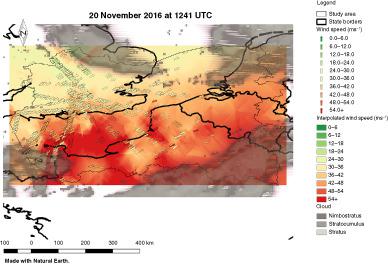
This study explored the use of Mode‐Selective Enhanced Surveillance (Mode‐S EHS) aircraft‐derived data interpretation using geographic information systems (GIS) for mapping weather fronts. An area covering south‐east England was chosen, with data from three separate days, covering named storms. Using kriging and statistical analysis methods in ArcGIS, it was determined that mapping was feasible, demonstrated where air masses corresponding to a weather front were clearly visible when plotted. The selection of appropriate data density to match processing requirements was discussed. It was concluded that GIS can improve analysis and presentation of Mode‐S EHS derived meterological data.
中文翻译:

在地理信息系统(GIS)软件中使用常规的高分辨率飞机衍生的英国观测数据进行实时天气前线制图的第一步
这项研究探索了使用模式选择性增强监视(Mode-S EHS)飞机衍生的数据解释方法,该方法通过地理信息系统(GIS)绘制天气前沿图。选择了一个覆盖英格兰东南部的区域,并提供了来自三天的数据,覆盖了命名为风暴。使用ArcGIS中的克里金法和统计分析方法,确定了制图是可行的,并证明了在绘制时可以清楚地看到与天气前沿对应的空气质量。讨论了选择合适的数据密度以匹配处理要求。结论是,GIS可以改善ModeS EHS得出的计量数据的分析和表示。
更新日期:2018-10-03
中文翻译:
在地理信息系统(GIS)软件中使用常规的高分辨率飞机衍生的英国观测数据进行实时天气前线制图的第一步
这项研究探索了使用模式选择性增强监视(Mode-S EHS)飞机衍生的数据解释方法,该方法通过地理信息系统(GIS)绘制天气前沿图。选择了一个覆盖英格兰东南部的区域,并提供了来自三天的数据,覆盖了命名为风暴。使用ArcGIS中的克里金法和统计分析方法,确定了制图是可行的,并证明了在绘制时可以清楚地看到与天气前沿对应的空气质量。讨论了选择合适的数据密度以匹配处理要求。结论是,GIS可以改善ModeS EHS得出的计量数据的分析和表示。


 京公网安备 11010802027423号