当前位置:
X-MOL 学术
›
Geomorphology
›
论文详情
Our official English website, www.x-mol.net, welcomes your
feedback! (Note: you will need to create a separate account there.)
A 5200-year paleoecological and geochemical record of coastal environmental changes and shoreline fluctuations in southwestern Louisiana: Implications for coastal sustainability
Geomorphology ( IF 3.1 ) Pub Date : 2020-09-01 , DOI: 10.1016/j.geomorph.2020.107284 Qiang Yao , Kam-biu Liu , Alejandro Antonio Aragón-Moreno , Erika Rodrigues , Y. Jun Xu , Nina S. Lam
Geomorphology ( IF 3.1 ) Pub Date : 2020-09-01 , DOI: 10.1016/j.geomorph.2020.107284 Qiang Yao , Kam-biu Liu , Alejandro Antonio Aragón-Moreno , Erika Rodrigues , Y. Jun Xu , Nina S. Lam
|
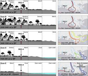
Abstract This study presents a 5200-year history of coastal environmental changes and shoreline fluctuations based on a multi-proxy sedimentary record developed from the eastern end of Louisiana's Chenier Plain. Palynological, loss-on ignition, grain-size, and X-ray fluorescence data for a 525 cm sedimentary core indicate five stages of ecosystem development in the Rockefeller Wildlife Refuge since the mid-Holocene. Between 5190 and 4240 cal yr BP, the relative sea-level was much lower than the present level, and our study area was occupied by a baldcypress swamp. When the Sale-Cypremont subdelta complex formed at a western position approximately 4600 years ago, our study area was transformed to a maritime forest about 4240–3440 cal yr BP, suggesting shoreline progradation. When the Mississippi River delta lobe switched to more easterly positions during the Teche, St. Bernard, Lafourche, and Plaquemine-Balize complexes, our study site was transformed back to a freshwater swamp between 3440 and 1520 cal yr BP and then to a coastal marsh between 1520 and 300 cal yr BP. After the Atchafalaya-Wax Lake subdelta complex formed at a more westerly position again, the modern-day beach form at 300 cal yr BP. These coastal ecosystem developments suggest that shoreline retreat started at ~3440 cal yr BP and persisted to the present day. In addition, evidence of at least four possible paleohurricane events was found during the late Holocene. Our multi-proxy record demonstrates that shoreline fluctuation in southwestern Louisiana was tied to the Mississippi River Delta Switch since the mid-Holocene. Shoreline progradation occurred during the Sale-Cypremont subdelta phase ~5200–3500 years ago, when the sediment supply was high. Retrogradation occurred after ~3500 cal yr BP when the Mississippi River subdelta complexes occupied more easterly position, resulting in diminished sediment supply. A significant increase in the delivery of water and total suspended sediment load from the Atchafalaya River to the Gulf of Mexico is needed in order to sustain the southwestern Louisiana coastal wetlands.
中文翻译:

路易斯安那州西南部海岸环境变化和海岸线波动的 5200 年古生态和地球化学记录:对海岸可持续性的影响
摘要 本研究基于路易斯安那州切尼尔平原东端的多代理沉积记录,展示了 5200 年的海岸环境变化和海岸线波动历史。525 厘米沉积岩心的孢粉学、烧失量、粒度和 X 射线荧光数据表明,洛克菲勒野生动物保护区自全新世中期以来的五个生态系统发展阶段。在 5190 到 4240 cal yr BP 之间,相对海平面远低于目前的水平,我们的研究区域被秃柏沼泽所占据。当大约 4600 年前在西部位置形成 Sale-Cypremont 亚三角洲复合体时,我们的研究区域在大约 4240-3440 cal BP 转变为海洋森林,表明海岸线进积。当密西西比河三角洲在 Teche、St. Bernard、Lafourche 和 Plaquemine-Balize 复合体期间转向更靠东的位置时,我们的研究地点在 3440 到 1520 cal BP 之间转变回淡水沼泽,然后转变为沿海沼泽在 1520 和 300 cal yr BP 之间。在 Atchafalaya-Wax Lake 亚三角洲复合体再次在更偏西的位置形成之后,现代海滩在 300 cal BP 时形成。这些沿海生态系统的发展表明,海岸线退缩始于约 3440 cal yr BP 并持续到今天。此外,在全新世晚期发现了至少四次可能发生的古飓风事件的证据。我们的多代理记录表明,自全新世中期以来,路易斯安那州西南部的海岸线波动与密西西比河三角洲开关有关。海岸线进积发生在大约 5200-3500 年前的 Sale-Cypremont 亚三角洲阶段,当时沉积物供应量很高。当密西西比河亚三角洲复合体占据更偏东的位置时,回生发生在大约 3500 cal yr BP 之后,导致沉积物供应减少。为了维持路易斯安那州西南部的沿海湿地,需要显着增加从阿查法拉亚河到墨西哥湾的水量和总悬浮泥沙量。
更新日期:2020-09-01
中文翻译:
路易斯安那州西南部海岸环境变化和海岸线波动的 5200 年古生态和地球化学记录:对海岸可持续性的影响
摘要 本研究基于路易斯安那州切尼尔平原东端的多代理沉积记录,展示了 5200 年的海岸环境变化和海岸线波动历史。525 厘米沉积岩心的孢粉学、烧失量、粒度和 X 射线荧光数据表明,洛克菲勒野生动物保护区自全新世中期以来的五个生态系统发展阶段。在 5190 到 4240 cal yr BP 之间,相对海平面远低于目前的水平,我们的研究区域被秃柏沼泽所占据。当大约 4600 年前在西部位置形成 Sale-Cypremont 亚三角洲复合体时,我们的研究区域在大约 4240-3440 cal BP 转变为海洋森林,表明海岸线进积。当密西西比河三角洲在 Teche、St. Bernard、Lafourche 和 Plaquemine-Balize 复合体期间转向更靠东的位置时,我们的研究地点在 3440 到 1520 cal BP 之间转变回淡水沼泽,然后转变为沿海沼泽在 1520 和 300 cal yr BP 之间。在 Atchafalaya-Wax Lake 亚三角洲复合体再次在更偏西的位置形成之后,现代海滩在 300 cal BP 时形成。这些沿海生态系统的发展表明,海岸线退缩始于约 3440 cal yr BP 并持续到今天。此外,在全新世晚期发现了至少四次可能发生的古飓风事件的证据。我们的多代理记录表明,自全新世中期以来,路易斯安那州西南部的海岸线波动与密西西比河三角洲开关有关。海岸线进积发生在大约 5200-3500 年前的 Sale-Cypremont 亚三角洲阶段,当时沉积物供应量很高。当密西西比河亚三角洲复合体占据更偏东的位置时,回生发生在大约 3500 cal yr BP 之后,导致沉积物供应减少。为了维持路易斯安那州西南部的沿海湿地,需要显着增加从阿查法拉亚河到墨西哥湾的水量和总悬浮泥沙量。


 京公网安备 11010802027423号