当前位置:
X-MOL 学术
›
Earth Surf.Process. Land.
›
论文详情
Our official English website, www.x-mol.net, welcomes your
feedback! (Note: you will need to create a separate account there.)
Decadal link between longitudinal morphological changes in branching channels of Yangtze Estuary and movement of the offshore depo‐center
Earth Surface Processes and Landforms ( IF 2.8 ) Pub Date : 2020-06-26 , DOI: 10.1002/esp.4923 Boyuan Zhu 1 , Yao Yue 2 , Alistair G.L. Borthwick 3 , Wenjun Yu 4 , Enhang Liang 5 , Jinwu Tang 6 , Yuanfang Chai 7 , Yitian Li 2
Earth Surface Processes and Landforms ( IF 2.8 ) Pub Date : 2020-06-26 , DOI: 10.1002/esp.4923 Boyuan Zhu 1 , Yao Yue 2 , Alistair G.L. Borthwick 3 , Wenjun Yu 4 , Enhang Liang 5 , Jinwu Tang 6 , Yuanfang Chai 7 , Yitian Li 2
Affiliation
|
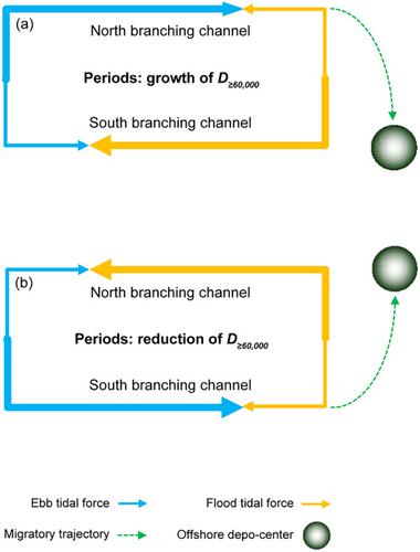
In estuaries, the morphology of inland and offshore areas usually evolves synergistically. This study examines the decadal link between longitudinal changes in morphology of branching channels and movement of the offshore depo-center (where sediment deposition rate is maximum) of the Yangtze River estuary, under intense human interference. Integrated data analysis is provided on morphology, runoff discharge, and ebb partition ratio from 1950 to 2017. Channel-volume reductions and change rates between isobaths in branching channels reflect the impact of estuarine engineering projects. Ebb partition ratio and duration of discharge ≥ 60 000 m3 s-1 act as proxies for the water excavating force in branching channels and runoff intensity. It is found that deposition occurs in the lower/upper sub-reaches (or further downstream/upstream channels) of the inland north/south branching channels, and the offshore depo-center moves southward or southeastward, as runoff intensity grows; the reverse occurs as runoff intensity declines. This is because the horizontal circumfluence in the Yangtze estuary rotates clockwise as ebb partition ratios of the north/south branching channels increase/decrease for increasing runoff, and conversely rotates anticlockwise for decreasing runoff. Land reclamation activities, the Deepwater Channel Project, and the Qingcaosha Reservoir have impacted greatly on longitudinal changes of morphology in the North Branch and the South Passage and on ebb partition ratio variations in the North/South Channel and the North/South Passage. Dam-induced runoff flattening has enhanced deposition in the upper/lower sub-reaches of the north/south branching channels and caused northward movement of the offshore depo-center, except in areas affected by estuarine engineering projects. Dam-induced longitudinal evolution of branching channel morphology and offshore depo-center movement will likely persist in the future, given the ongoing construction of large cascade dams in the upper Yangtze and the completion of major projects in the Yangtze estuary.
中文翻译:

长江口支流河道纵向形态变化与近海沉积中心运动的年代际联系
在河口,内陆和近海地区的形态通常是协同演化的。本研究考察了在强烈的人为干扰下,支流河道形态的纵向变化与长江口近海沉积中心(沉积物沉积速率最大)的运动之间的年代际联系。提供了 1950 年至 2017 年的形态、径流流量和退潮分配比的综合数据分析。 支流河道中河道容积减少和等深线之间的变化率反映了河口工程项目的影响。退潮分配比和排放持续时间≥ 60 000 m3 s-1 作为分支渠道中的开水力和径流强度的代理。发现内陆北/南支流河道的下/上子河道(或更下游/上游的河道)发生沉积,随着径流强度的增加,近海沉积中心向南或东南移动;随着径流强度的下降,情况正好相反。这是因为长江口水平环流随着北/南支河道退潮分配比的增加/减少而顺时针旋转,以增加径流,反之逆时针旋转以减少径流。填海工程、深水航道工程和青草沙水库对北支、南航道地貌纵向变化、北/南航道、北/南航道退潮分配比变化影响较大。除受河口工程影响的地区外,大坝引起的径流变平增强了北/南支河道上/下子河段的沉积,并导致近海沉积中心向北移动。鉴于长江上游大型梯级坝的建设和长江口重大工程的竣工,大坝引起的支流河道形态的纵向演变和近海沉积中心运动可能会在未来持续存在。
更新日期:2020-06-26
中文翻译:
长江口支流河道纵向形态变化与近海沉积中心运动的年代际联系
在河口,内陆和近海地区的形态通常是协同演化的。本研究考察了在强烈的人为干扰下,支流河道形态的纵向变化与长江口近海沉积中心(沉积物沉积速率最大)的运动之间的年代际联系。提供了 1950 年至 2017 年的形态、径流流量和退潮分配比的综合数据分析。 支流河道中河道容积减少和等深线之间的变化率反映了河口工程项目的影响。退潮分配比和排放持续时间≥ 60 000 m3 s-1 作为分支渠道中的开水力和径流强度的代理。发现内陆北/南支流河道的下/上子河道(或更下游/上游的河道)发生沉积,随着径流强度的增加,近海沉积中心向南或东南移动;随着径流强度的下降,情况正好相反。这是因为长江口水平环流随着北/南支河道退潮分配比的增加/减少而顺时针旋转,以增加径流,反之逆时针旋转以减少径流。填海工程、深水航道工程和青草沙水库对北支、南航道地貌纵向变化、北/南航道、北/南航道退潮分配比变化影响较大。除受河口工程影响的地区外,大坝引起的径流变平增强了北/南支河道上/下子河段的沉积,并导致近海沉积中心向北移动。鉴于长江上游大型梯级坝的建设和长江口重大工程的竣工,大坝引起的支流河道形态的纵向演变和近海沉积中心运动可能会在未来持续存在。


 京公网安备 11010802027423号