Estuarine, Coastal and Shelf Science ( IF 2.6 ) Pub Date : 2020-05-27 , DOI: 10.1016/j.ecss.2020.106862 Janine B. Adams , Anusha Rajkaran
|
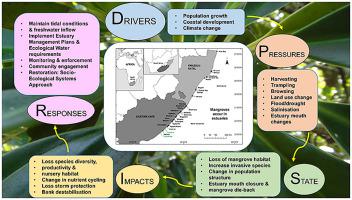
Mangroves in South Africa occur at one of the most southerly locations in the world, which provides a unique opportunity to study their dynamic responses to anthropogenic and natural perturbations. The exposed high-energy South African coastline restricts mangroves to 32 sheltered estuaries of which 18 (56%) are predominantly open to the sea. A large area of mangrove (47% of the country total) occurs in the uMhlathuze Estuary – a novel ecosystem formed by the creation of an artificial mouth. A Drivers-Pressures-State-Impacts-Response (DPSIR) framework was applied to understand factors of change and highlight governance and management responses. The largest mangrove area (440 ha) was lost during the construction of Durban Bay harbour. Mangroves (∼7 ha) no longer occur in 10 small KwaZulu-Natal estuaries as a result of catchment and mouth disturbance. In the Eastern Cape, pressures are escalating in the form of harvesting for wood, cattle browsing and changes in mouth condition. Climate related warming and an increase in CO2 are positive conditions for mangroves to expand their distribution to higher latitudes but this will depend on propagule dispersal between estuaries and the availability of suitable habitats. Many of the small estuaries are temporarily closed to the sea for different periods thus limiting recruitment. An increase in the intensity of freshwater floods will scour banks and completely remove mangroves. It is important that these dynamic responses are understood and incorporated into management plans so that mangrove forests can be better protected and conserved.
中文翻译:
红树林在其最南端的非洲分布极限处的变化
南非的红树林位于世界上最南端的位置之一,这为研究其对人为和自然干扰的动态响应提供了独特的机会。暴露在外的高能量南非海岸线将红树林限制在32个庇护河口中,其中18个(56%)主要向海开放。uMhlathuze河口有大片红树林(占全国总数的47%),这是通过人工嘴形成的新型生态系统。应用了驱动程序-压力-状态-影响-响应(DPSIR)框架,以了解变化的因素并强调治理和管理响应。在德班湾港口建设期间,最大的红树林面积(440公顷)消失了。由于集水区和河口干扰,在10个夸祖鲁-纳塔尔省的小河口不再有红树林(约7公顷)。在东开普省,木材采伐,牲畜浏览和口型变化的压力正在加剧。与气候有关的变暖和一氧化碳的增加2是红树林将其分布扩展到更高纬度的积极条件,但这将取决于河口之间的传播扩散和合适栖息地的可用性。许多小型河口在不同时期暂时关闭海域,从而限制了招募工作。淡水洪水的强度增加将冲刷河岸并完全清除红树林。理解这些动态响应并将其纳入管理计划非常重要,这样才能更好地保护和保护红树林。


 京公网安备 11010802027423号