当前位置:
X-MOL 学术
›
Remote Sens. Environ.
›
论文详情
Our official English website, www.x-mol.net, welcomes your
feedback! (Note: you will need to create a separate account there.)
Assessing satellite-derived fire patches with functional diversity trait methods
Remote Sensing of Environment ( IF 11.1 ) Pub Date : 2020-09-01 , DOI: 10.1016/j.rse.2020.111897 M. Vanesa Moreno , Pierre Laurent , Philippe Ciais , Florent Mouillot
Remote Sensing of Environment ( IF 11.1 ) Pub Date : 2020-09-01 , DOI: 10.1016/j.rse.2020.111897 M. Vanesa Moreno , Pierre Laurent , Philippe Ciais , Florent Mouillot
|
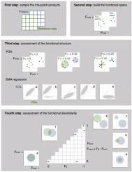
Abstract Fire disturbance is a significant component of the climate system. Analysis of satellite-derived burned areas has allowed the identification of fire patches and their morphology as a new resource for tracking fire spread to improve fire models used to assess the impact of fires on climate and the carbon cycle. A critical parameter of the flood-fill algorithm used to create fire patches is the cut-off (in days) below which it aggregates two contiguous burned pixels to the same fire patch. However, the current level of validation is insufficient to understand the effect of the cut-off values and sensor resolutions on the subsequent fire-patch morphology. The FRY v1.0 database of functional fire-patch traits (e.g., size, elongation, and direction) emanates from the analyses of two global burned-area products derived from MODIS and MERIS sensors with different spatial and temporal resolutions and with cut-off values of 3, 5, 9, and 14 days. To evaluate whether the FRY products are accurately identifying the spatial features of fire patches and what are the most realistic cut-off values to use in different sub-regions of North America, we propose a new functional diversity trait-based approach, which compares the satellite-derived fire patches to forest service perimeters as reference data. This paper shows the accuracy of the FRY fire patches ≥300 ha in North America during 2005–2011. Our analysis demonstrates that fire patches with a high cut-off of 14 days and those derived from the MODIS sensor, with their high temporal resolution, better identify the fire diversity in North America. In conclusion, our statistical framework can be used for assessing satellite-derived fire patches. Furthermore, the temporal resolution of satellite sensors is the most important factor in identifying fire patches — thus space agencies should consider it when planning the future development of cost-effective climate observation systems.
中文翻译:

用功能多样性特征方法评估卫星衍生的火斑
摘要 火灾扰动是气候系统的重要组成部分。对卫星衍生的燃烧区域的分析使得可以识别火斑及其形态,作为跟踪火势蔓延的新资源,以改进用于评估火灾对气候和碳循环影响的火灾模型。用于创建火斑的洪水填充算法的一个关键参数是截止值(以天为单位),低于此值它将两个连续的燃烧像素聚合到同一个火斑。然而,目前的验证水平不足以了解截止值和传感器分辨率对后续火斑形态的影响。FRY v1.0 功能性火斑特征数据库(例如,尺寸、伸长率、和方向)源自对 MODIS 和 MERIS 传感器的两种全球燃烧区域产品的分析,这些产品具有不同的空间和时间分辨率,截止值为 3、5、9 和 14 天。为了评估 FRY 产品是否准确识别火斑的空间特征以及在北美不同子区域使用的最现实的临界值是什么,我们提出了一种新的基于功能多样性特征的方法,该方法比较了卫星衍生的火斑到森林服务周界作为参考数据。本文显示了 2005 年至 2011 年北美地区≥300 公顷的 FRY 火灾斑块的准确性。我们的分析表明,具有 14 天高截止时间的火灾斑块和源自 MODIS 传感器的具有高时间分辨率的火灾斑块,更好地识别北美的火灾多样性。总之,我们的统计框架可用于评估卫星衍生的火斑。此外,卫星传感器的时间分辨率是识别火斑的最重要因素——因此空间机构在规划具有成本效益的气候观测系统的未来发展时应考虑到这一点。
更新日期:2020-09-01
中文翻译:
用功能多样性特征方法评估卫星衍生的火斑
摘要 火灾扰动是气候系统的重要组成部分。对卫星衍生的燃烧区域的分析使得可以识别火斑及其形态,作为跟踪火势蔓延的新资源,以改进用于评估火灾对气候和碳循环影响的火灾模型。用于创建火斑的洪水填充算法的一个关键参数是截止值(以天为单位),低于此值它将两个连续的燃烧像素聚合到同一个火斑。然而,目前的验证水平不足以了解截止值和传感器分辨率对后续火斑形态的影响。FRY v1.0 功能性火斑特征数据库(例如,尺寸、伸长率、和方向)源自对 MODIS 和 MERIS 传感器的两种全球燃烧区域产品的分析,这些产品具有不同的空间和时间分辨率,截止值为 3、5、9 和 14 天。为了评估 FRY 产品是否准确识别火斑的空间特征以及在北美不同子区域使用的最现实的临界值是什么,我们提出了一种新的基于功能多样性特征的方法,该方法比较了卫星衍生的火斑到森林服务周界作为参考数据。本文显示了 2005 年至 2011 年北美地区≥300 公顷的 FRY 火灾斑块的准确性。我们的分析表明,具有 14 天高截止时间的火灾斑块和源自 MODIS 传感器的具有高时间分辨率的火灾斑块,更好地识别北美的火灾多样性。总之,我们的统计框架可用于评估卫星衍生的火斑。此外,卫星传感器的时间分辨率是识别火斑的最重要因素——因此空间机构在规划具有成本效益的气候观测系统的未来发展时应考虑到这一点。


 京公网安备 11010802027423号