当前位置:
X-MOL 学术
›
Earth Surf.Process. Land.
›
论文详情
Our official English website, www.x-mol.net, welcomes your
feedback! (Note: you will need to create a separate account there.)
Using visibility analysis to improve point density and processing time of SfM‐MVS techniques for 3D reconstruction of landforms
Earth Surface Processes and Landforms ( IF 2.8 ) Pub Date : 2020-06-09 , DOI: 10.1002/esp.4910 Álvaro Gómez‐Gutiérrez 1, 2 , Trent Biggs 1 , Napoleon Gudino‐Elizondo 1, 3, 4 , Paz Errea 5 , Esteban Alonso‐González 5 , Estela Nadal Romero 5, 6 , José Juan Sanjosé Blasco 2
Earth Surface Processes and Landforms ( IF 2.8 ) Pub Date : 2020-06-09 , DOI: 10.1002/esp.4910 Álvaro Gómez‐Gutiérrez 1, 2 , Trent Biggs 1 , Napoleon Gudino‐Elizondo 1, 3, 4 , Paz Errea 5 , Esteban Alonso‐González 5 , Estela Nadal Romero 5, 6 , José Juan Sanjosé Blasco 2
Affiliation
|
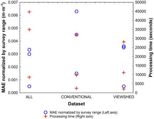
Image network geometry, including the number and orientation of images, impacts the error, coverage, and processing time of 3D terrain mapping performed using structure‐from‐motion and multiview‐stereo (SfM‐MVS). Few studies have quantified trade‐offs in error and processing time or ways to optimize image acquisition in diverse topographic conditions. Here, we determine suitable camera locations for image acquisition by minimizing the occlusion produced by topography. Viewshed analysis is used to select the suitable images, which requires a preliminary digital elevation model (DEM), potential camera locations, and sensor parameters. One aerial and two ground‐based image collections were used to analyse differences between SfM‐MVS models produced using: (1) all available images (ALL); (2) images selected using conventional methods (CON); and (3) images selected using the viewshed analysis (VIEW). The resulting models were compared with benchmark point clouds acquired by a terrestrial laser scanner (TLS) and TLS‐derived DEMs. The VIEW datasets produced denser point clouds (28–32% more points) and DEMs with up to 66% reduction in error compared with CON datasets due to reduction of gaps in the DEM. VIEW datasets reduced processing time by 37–76% compared with ALL, with no reduction in coverage or increase in error. DEMs produced with ALL and VIEW datasets had similar slope and roughness, while slight differences that may be locally important were observed for the CON dataset. The new method helps optimize SfM‐MVS image collection strategies that significantly reduce the number of images required with minimal loss in coverage or accuracy over complex surfaces. © 2020 John Wiley & Sons, Ltd.
中文翻译:

使用能见度分析来改善SfM-MVS技术用于地形3D重建的点密度和处理时间
图像网络的几何形状(包括图像的数量和方向)会影响使用动感结构和多视图立体(SfM-MVS)执行的3D地形映射的错误,覆盖范围和处理时间。很少有研究量化误差和处理时间或在不同地形条件下优化图像采集的方式之间的折衷。在这里,我们通过最小化地形产生的遮挡来确定合适的相机位置以进行图像采集。视域分析用于选择合适的图像,这需要初步的数字高程模型(DEM),潜在的摄像机位置和传感器参数。使用一个航空图像和两个地面图像集来分析使用以下方法产生的SfM-MVS模型之间的差异:(1)所有可用图像(ALL);(2)使用常规方法(CON)选择的图像;(3)使用视域分析(VIEW)选择的图像。将生成的模型与地面激光扫描仪(TLS)和TLS衍生的DEM获取的基准点云进行了比较。与CON数据集相比,VIEW数据集产生了更密集的点云(增加了28-32%的点)和DEM,与之相比,由于DEM间隙的减少,误差减少了66%。与ALL相比,VIEW数据集将处理时间减少了37–76%,而覆盖范围没有减少或错误没有增加。用ALL和VIEW数据集生成的DEM具有相似的斜率和粗糙度,而对于CON数据集则观察到可能在局部上很重要的细微差异。新方法有助于优化SfM-MVS图像收集策略,从而显着减少所需图像的数量,同时在复杂表面上的覆盖率或准确性损失最小。©2020约翰·威利&
更新日期:2020-06-09
中文翻译:
使用能见度分析来改善SfM-MVS技术用于地形3D重建的点密度和处理时间
图像网络的几何形状(包括图像的数量和方向)会影响使用动感结构和多视图立体(SfM-MVS)执行的3D地形映射的错误,覆盖范围和处理时间。很少有研究量化误差和处理时间或在不同地形条件下优化图像采集的方式之间的折衷。在这里,我们通过最小化地形产生的遮挡来确定合适的相机位置以进行图像采集。视域分析用于选择合适的图像,这需要初步的数字高程模型(DEM),潜在的摄像机位置和传感器参数。使用一个航空图像和两个地面图像集来分析使用以下方法产生的SfM-MVS模型之间的差异:(1)所有可用图像(ALL);(2)使用常规方法(CON)选择的图像;(3)使用视域分析(VIEW)选择的图像。将生成的模型与地面激光扫描仪(TLS)和TLS衍生的DEM获取的基准点云进行了比较。与CON数据集相比,VIEW数据集产生了更密集的点云(增加了28-32%的点)和DEM,与之相比,由于DEM间隙的减少,误差减少了66%。与ALL相比,VIEW数据集将处理时间减少了37–76%,而覆盖范围没有减少或错误没有增加。用ALL和VIEW数据集生成的DEM具有相似的斜率和粗糙度,而对于CON数据集则观察到可能在局部上很重要的细微差异。新方法有助于优化SfM-MVS图像收集策略,从而显着减少所需图像的数量,同时在复杂表面上的覆盖率或准确性损失最小。©2020约翰·威利&


 京公网安备 11010802027423号