ISPRS Journal of Photogrammetry and Remote Sensing ( IF 10.6 ) Pub Date : 2020-05-20 , DOI: 10.1016/j.isprsjprs.2020.04.017 Kasper Johansen , Qibin Duan , Yu-Hsuan Tu , Chris Searle , Dan Wu , Stuart Phinn , Andrew Robson , Matthew F. McCabe
|
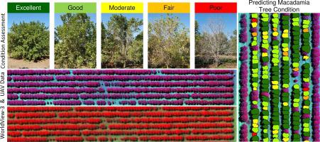
Australia is one of the world’s largest producers of macadamia nuts. As macadamia trees can take up to 15 years to mature and produce maximum yield, it is important to optimize tree condition. Field based assessment of macadamia tree condition is time-consuming and often inconsistent. Using remotely sensed imagery may allow for faster, more extensive, and more consistent assessment of macadamia tree condition. To identify individual macadamia tree crowns, high spatial resolution imagery is required. Hence, the objective of this work was to develop and test an approach to map the condition of individual macadamia tree crowns using both multi-spectral Unmanned Aerial Vehicle (UAV) and WorldView-3 imagery for different macadamia varieties and three different sites located near Bundaberg, Australia. A random forest classifier, based on all available spectral bands and selected vegetation indices was used to predict five condition categories, ranging from excellent (category 1) to poor (category 5). Various combinations of the developed models were tested between the three sites and over time. The results showed that the multi-spectral WorldView-3 imagery produced the lowest out of bag (OOB) classification errors in most cases. However, for both the UAV and the WorldView-3 imagery, more than 98.5% of predicted macadamia condition categories were either correctly mapped or offset by a single category out of the five condition categories (excellent, good, moderate, fair and poor) for trees of the same variety and at one point in time. Multi-temporally, the WorldView-3 imagery performed better than the UAV data for predicting the condition of the same macadamia tree variety. Applying a model from one site to another site with the same macadamia tree variety produced OOB classification between 31.20 and 42.74%, but with >98.63% of trees predicted within a single condition category. Importantly, models trained based on one type of macadamia tree variety could not be successfully applied to a site with another variety. The developed classification models may be used as a decision and management support tool for the macadamia industry to inform management practices and improve on-demand irrigation, fertilization, and pest inspection at the individual tree level.
中文翻译:
使用多光谱无人机和WorldView-3影像绘制澳洲坚果树作物的状况图
澳大利亚是世界上最大的澳洲坚果生产国之一。由于澳洲坚果树可能需要长达15年的时间才能成熟并产生最大产量,因此优化树木状况非常重要。对澳洲坚果树状况进行基于现场的评估非常耗时,而且常常不一致。使用遥感影像可以对澳洲坚果树状况进行更快,更广泛和更一致的评估。为了识别单个澳洲坚果树冠,需要高分辨率的图像。因此,这项工作的目的是开发和测试一种方法,使用多光谱无人飞行器(UAV)和WorldView-3影像对不同的澳洲坚果品种和位于邦德堡附近的三个不同地点进行制图,以绘制单个澳洲坚果树冠的状况,澳大利亚。随机森林分类器 根据所有可用光谱带和选定的植被指数来预测五个条件类别,从优等(类别1)到差(类别5)。在三个站点之间并随时间测试了开发模型的各种组合。结果表明,在大多数情况下,多光谱WorldView-3图像产生的最低袋装(OOB)分类错误。但是,对于无人机和WorldView-3影像,在以下五个条件类别(优秀,良好,中等,中等和较差)中,超过98.5%的预测澳洲坚果状况类别已被正确映射或被一个类别抵消了同一时刻的同一棵树木。多时间 WorldView-3影像在预测相同澳洲坚果树种状况方面的表现优于无人机数据。将模型从一个地点应用到具有相同澳洲坚果树变种的另一个地点,可以将OOB分类在31.20%和42.74%之间,但是在单个条件类别内预测的树木中有> 98.63%。重要的是,基于一种澳洲坚果树变种训练的模型无法成功应用于具有另一种变种的站点。所开发的分类模型可以用作澳洲坚果产业的决策和管理支持工具,以指导管理实践并改善单棵树上的按需灌溉,施肥和病虫害检查。74%,但在单个条件类别内预测的树木> 98.63%。重要的是,基于一种澳洲坚果树变种训练的模型无法成功应用于具有另一种变种的站点。所开发的分类模型可以用作澳洲坚果产业的决策和管理支持工具,以指导管理实践并改善单棵树上的按需灌溉,施肥和病虫害检查。74%,但在单个条件类别内预测的树木> 98.63%。重要的是,基于一种澳洲坚果树变种训练的模型无法成功应用于具有另一种变种的站点。所开发的分类模型可以用作澳洲坚果产业的决策和管理支持工具,以指导管理实践并改善单棵树上的按需灌溉,施肥和病虫害检查。


 京公网安备 11010802027423号