当前位置:
X-MOL 学术
›
Basin Res.
›
论文详情
Our official English website, www.x-mol.net, welcomes your
feedback! (Note: you will need to create a separate account there.)
Stratigraphic architecture of Solander Basin records Southern Ocean currents and subduction initiation beneath southwest New Zealand
Basin Research ( IF 2.8 ) Pub Date : 2020-06-03 , DOI: 10.1111/bre.12473 Jiten Patel 1 , Rupert Sutherland 1 , Michael Gurnis 2 , Harm Van Avendonk 3 , Sean P. S. Gulick 3, 4 , Brandon Shuck 3, 4 , Joann Stock 2 , Erin Hightower 2
Basin Research ( IF 2.8 ) Pub Date : 2020-06-03 , DOI: 10.1111/bre.12473 Jiten Patel 1 , Rupert Sutherland 1 , Michael Gurnis 2 , Harm Van Avendonk 3 , Sean P. S. Gulick 3, 4 , Brandon Shuck 3, 4 , Joann Stock 2 , Erin Hightower 2
Affiliation
|
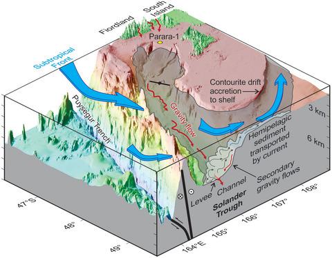
Solander Basin is currently characterised by subduction initiation at the Pacific‐Australia plate boundary, where high biological productivity is found at the northern edge of the Antarctic Circumpolar Current. Sedimentary architecture results from tectonic influences on accommodation space, sediment supply, and ocean currents (via physiography); and climate influence on ocean currents and biological productivity. We present the first seismic‐stratigraphic analysis of Solander Basin based on high‐fold seismic‐reflection data (voyage MGL1803, SISIE). Solander Trough physiography formed by Eocene rifting, but basinal strata are mostly younger than ~17 Ma, when we infer Puysegur Ridge formed and sheltered Solander Basin from bottom currents, and mountain growth onshore increased sediment supply. Initial inversion on the Tauru Fault started at ~15 Ma, but reverse faulting from 12 to ~8 Ma on both the Tauru and Parara Faults was likely associated with reorganization and formation of the subduction thrust. The new seabed topography forced sediment pathways to become channelized at low points or antecedent gorges. Since 5 Ma, southern Puysegur Ridge and Fiordland mountains spread out towards the east and Solander Anticline grew in response to ongoing subduction and growth of a slab. Solander Basin had high sedimentation rates because: (1) it is sheltered from bottom currents by Puysegur Ridge; and (2) it has a mountainous land area that supplies sediment to its northern end. Sedimentary architecture is asymmetric due to the Subtropical Front, which moves pelagic and hemi‐pelagic sediment, including dilute parts of gravity flows, eastward and accretes contourites to the shelf south of Stewart Island. Levees, scours, drifts, and ridges of folded sediment characterize western Solander Basin, whereas hemi‐pelagic drape and secondary gravity flows are found east of the meandering axial Solander Channel. The high‐resolution record of climate and tectonics that Solander Basin contains may yield excellent sites for future scientific ocean drilling.
中文翻译:

索兰德盆地的地层结构记录了新西兰西南部下方的南大洋洋流和俯冲开始
Solander盆地目前的特征是在太平洋-澳大利亚板块边界开始俯冲,在南极环极流的北部边缘发现了高生物生产力。沉积结构是由构造对容纳空间、沉积物供应和洋流(通过地理学)的影响造成的;和气候对洋流和生物生产力的影响。我们首次基于高倍地震反射数据(航次 MGL1803,SISIE)对索兰德盆地进行了地震地层分析。Solander海槽地貌由始新世裂谷形成,但盆地地层大多年龄小于~17 Ma,当我们推断Puysegur海岭形成并从底流遮蔽Solander盆地时,陆上山地生长增加了沉积物供应。陶鲁断层的初始反转开始于~15 Ma,但在 Tauru 和 Parara 断层上从 12 Ma 到 ~8 Ma 的反向断层可能与俯冲逆冲的重组和形成有关。新的海底地形迫使沉积物通道在低点或先行峡谷处形成沟渠。自 5 Ma 以来,Puysegur Ridge 南部和 Fiordland 山脉向东扩展,Solander 背斜随着板块的持续俯冲和增长而增长。索兰德盆地的沉积速率高是因为:(1) 它被 Puysegur Ridge 挡住了底流;(2) 有向北端供给沉积物的山区陆域。由于亚热带锋移动远洋和半远洋沉积物,包括重力流的稀释部分,沉积结构是不对称的,向东并在斯图尔特岛以南的陆架上堆积等高岩。褶皱沉积物的堤坝、冲刷、漂流和脊是索兰德盆地西部的特征,而在蜿蜒的轴向索兰德海峡以东发现半远洋悬垂和二次重力流。索兰德盆地包含的气候和构造的高分辨率记录可能会为未来的科学海洋钻探提供极好的地点。
更新日期:2020-06-03
中文翻译:
索兰德盆地的地层结构记录了新西兰西南部下方的南大洋洋流和俯冲开始
Solander盆地目前的特征是在太平洋-澳大利亚板块边界开始俯冲,在南极环极流的北部边缘发现了高生物生产力。沉积结构是由构造对容纳空间、沉积物供应和洋流(通过地理学)的影响造成的;和气候对洋流和生物生产力的影响。我们首次基于高倍地震反射数据(航次 MGL1803,SISIE)对索兰德盆地进行了地震地层分析。Solander海槽地貌由始新世裂谷形成,但盆地地层大多年龄小于~17 Ma,当我们推断Puysegur海岭形成并从底流遮蔽Solander盆地时,陆上山地生长增加了沉积物供应。陶鲁断层的初始反转开始于~15 Ma,但在 Tauru 和 Parara 断层上从 12 Ma 到 ~8 Ma 的反向断层可能与俯冲逆冲的重组和形成有关。新的海底地形迫使沉积物通道在低点或先行峡谷处形成沟渠。自 5 Ma 以来,Puysegur Ridge 南部和 Fiordland 山脉向东扩展,Solander 背斜随着板块的持续俯冲和增长而增长。索兰德盆地的沉积速率高是因为:(1) 它被 Puysegur Ridge 挡住了底流;(2) 有向北端供给沉积物的山区陆域。由于亚热带锋移动远洋和半远洋沉积物,包括重力流的稀释部分,沉积结构是不对称的,向东并在斯图尔特岛以南的陆架上堆积等高岩。褶皱沉积物的堤坝、冲刷、漂流和脊是索兰德盆地西部的特征,而在蜿蜒的轴向索兰德海峡以东发现半远洋悬垂和二次重力流。索兰德盆地包含的气候和构造的高分辨率记录可能会为未来的科学海洋钻探提供极好的地点。


 京公网安备 11010802027423号