Marine Geology ( IF 2.6 ) Pub Date : 2020-05-19 , DOI: 10.1016/j.margeo.2020.106239 Karolina Trzcinska , Lukasz Janowski , Jaroslaw Nowak , Maria Rucinska-Zjadacz , Aleksandra Kruss , Jens Schneider von Deimling , Pawel Pocwiardowski , Jaroslaw Tegowski
|
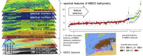
Automatic methods of seafloor mapping are still in their early stage of development, despite the technical progress made in recent years. A serious imperfection is the limited types of predictor features available for seabed classification. It is therefore desirable to introduce new class of spectral features to benthic habitat mapping. In this study, we introduced eight spectral features of a rough seafloor surface that were indicative of better seabed classification. We compared them with traditional secondary features, like terrain variables and textural features. The suitability of 48 variables was tested, and the most important features were identified. The selected variables were used to perform a supervised object-based image analysis using four machine learning algorithms. We found that backscatter was the strongest predictor, followed by several spectral features from bathymetry that appeared more predictive than bathymetry itself. The highest overall accuracy of predictive model reached approximately 86% using the support vector machine classifier. The innovative results of this study suggest further application of the spectral features for predictive benthic habitat mapping, including research based on multi-frequency multibeam echosounder datasets. The utilisation of spectral features derived from bathymetry provide an important step towards more accurate maps of benthic habitats and seabed sediments composition.
中文翻译:
海底生境制图的双频多波束回波测深数据的频谱特征
尽管近年来取得了技术进步,但自动海底标测方法仍处于发展初期。一个严重的缺陷是可用于海床分类的有限的预测特征类型。因此,希望将新的光谱特征引入底栖生境制图。在这项研究中,我们介绍了粗糙海底表面的八个光谱特征,这些特征指示了更好的海床分类。我们将它们与传统的次要特征(例如地形变量和纹理特征)进行了比较。测试了48个变量的适用性,并确定了最重要的功能。所选变量用于使用四种机器学习算法执行基于对象的监督图像分析。我们发现反向散射是最强的预测因子,其次是测深仪的一些光谱特征,比测深仪本身更具预测性。使用支持向量机分类器,预测模型的最高总体准确性达到约86%。这项研究的创新结果表明,光谱特征可进一步用于预测底栖生物栖息地的测绘,包括基于多频多波束回波测深仪数据集的研究。利用测深法得出的光谱特征为向底栖生境和海底沉积物组成更精确的地图迈出了重要的一步。这项研究的创新结果表明,光谱特征可进一步用于预测底栖生物栖息地的测绘,包括基于多频多波束回波测深仪数据集的研究。利用测深法得出的光谱特征为向底栖生境和海底沉积物组成更精确的地图迈出了重要的一步。这项研究的创新结果表明,光谱特征可进一步用于预测底栖生物栖息地的测绘,包括基于多频多波束回波测深仪数据集的研究。利用测深法得出的光谱特征为向底栖生境和海底沉积物组成更精确的地图迈出了重要的一步。


 京公网安备 11010802027423号