Geomechanics for Energy and the Environment ( IF 3.3 ) Pub Date : 2019-08-05 , DOI: 10.1016/j.gete.2019.100137 Thomas Bérard , Jean Desroches
|
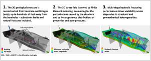
Wellbore-centric Earth models generally rely on one-dimensional assumptions (flat layers, laterally uniform properties, etc.). This is mostly due to a lack of means to resolve three-dimensional heterogeneities away from the well — core and log data lack depth of investigation while seismic imaging resolution is often no better than a few tens of meters laterally. In this paper, we used case examples from the Fayetteville, Niobrara and Marcellus US shale plays to demonstrate how borehole structural geology, based on borehole-wall images alone, allows to document the geological structure in 3D (faults and natural fractures included) with high resolution, up to tens to hundreds of meters away from the well — a dimension characteristic of hydraulic fractures. We investigated on those examples whether 1D assumptions were violated. In all three cases, structural features (folding and faulting) were observed with amplitudes up to tens of meters, though below seismic resolution. Borehole-wall images further provided information on natural fracture orientation and distribution, which enabled discrete fracture network modeling. Thanks to the 3D nature of the structural model, the effects of the structure, rock mass anisotropy and heterogeneity, were better accounted for when modeling geomechanical conditions. Well log and core data were positioned more accurately with respect to the layers and lateral variability in both material properties and pressure was therefore better assessed. Moreover, faults and natural fractures were accounted for. All of these effects were observed to be significant on the stress field along layers, across fault blocks, and at discontinuities, including significant stress rotations and substantial effects in stress magnitudes. We finally show how horizontal well placement and hydraulic fracturing are sensitive to such 3D effects. We conclude that, at the scale of a square mile, the Earth is not everywhere flat and that Earth models no longer need to be.
中文翻译:
平方英里范围内的地质结构,地质力学扰动和水力压裂性能的变化
以井眼为中心的地球模型通常依赖于一维假设(平坦层,横向均匀特性等)。这主要是由于缺乏解决远离井眼的三维异质性的方法-岩心和测井数据缺乏调查深度,而地震成像分辨率通常不超过横向数十米。在本文中,我们使用了Fayetteville,Niobrara和Marcellus美国页岩油藏中的案例,来证明仅基于井壁图像的井眼结构地质如何能够以很高的分辨率记录3D地质构造(包括断层和天然裂缝)距井口数十米至数百米的分辨率-水力压裂的尺寸特征。我们在这些示例中调查了是否违反一维假设。在这三种情况下,观测到的结构特征(褶皱和断层)的振幅高达几十米,尽管低于地震分辨率。井壁图像进一步提供了有关自然裂缝方向和分布的信息,从而可以进行离散裂缝网络建模。由于结构模型的3D性质,在对地质力学条件进行建模时,可以更好地考虑结构的影响,岩体各向异性和异质性。测井和岩心数据相对于各层定位更准确,因此可以更好地评估材料特性和压力方面的横向变化。此外,还包括了断层和自然裂缝。观察到所有这些影响对于沿层,跨断层块和不连续处的应力场都非常重要,包括明显的应力旋转和应力大小的重大影响。最后,我们展示了水平井布置和水力压裂如何对此类3D效果敏感。我们得出的结论是,在平方英里的范围内,地球并非到处都是平坦的,并且不再需要地球模型。


 京公网安备 11010802027423号