当前位置:
X-MOL 学术
›
Geothermics
›
论文详情
Our official English website, www.x-mol.net, welcomes your
feedback! (Note: you will need to create a separate account there.)
Geophysical constraints on the Luhoi (Tanzania) geothermal conceptual model
Geothermics ( IF 3.5 ) Pub Date : 2020-09-01 , DOI: 10.1016/j.geothermics.2020.101875 Egidio Armadillo , Daniele Rizzello , Claudio Pasqua , Paolo Pisani , Alessandro Ghirotto , Kato Kabaka , Taramaeli Mnjokava , Jonas Mwano , Makoye Didas , Lucas Tumbu
Geothermics ( IF 3.5 ) Pub Date : 2020-09-01 , DOI: 10.1016/j.geothermics.2020.101875 Egidio Armadillo , Daniele Rizzello , Claudio Pasqua , Paolo Pisani , Alessandro Ghirotto , Kato Kabaka , Taramaeli Mnjokava , Jonas Mwano , Makoye Didas , Lucas Tumbu
|
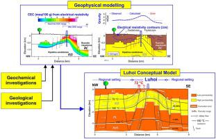
Abstract We present the results of the gravimetric, magnetic and magnetotelluric geophysical campaign aimed to constrain the geothermal conceptual model of the Luhoi geothermal field, a poorly known system located in the Tanzanian southeastern coastal sedimentary basin. Regional assessment by existing potential field data reveals that Luhoi lies at the margin of a wide regional NE trending uplifted block that involves the Precambrian metamorphic basement complex. In the geothermal field area, 3D geophysical modelling has imaged a local asymmetric horst of Cretaceous age, 1 km wide and 5 km long, with the same regional NE trend. The horst is formed by the denser Kipatimu Lower Cretaceous sandstones surrounded by the Upper Cretaceous Ruaruke claystones that are down thrown up to 1 km by normal faulting. Far from the horst, lithology mainly controls the modelled electrical resistivity distribution: the Ruaruke claystones show low resistivity (1–6 Ωm) primarily due to its clay content, while the Kipatimu sandstones have generally higher resistivity (10–30 Ωm) because of their prevalent electrolytic conduction. However, anomalous low resistivity values (1–5 Ωm) in the shallower portion of the Kipatimu sandstones forming the horst indicate enhanced electrical conduction due to the cation exchange capacity (CEC) of clay. The CEC estimated values from electrical resistivity are in the range 2−30 meq/100 g, suggesting the presence of kaolinite and illite and excluding the occurrence of smectite, which is the typical clay mineral in the cap-rock of high-temperature geothermal systems. This shallow clay-rich layer together with the Ruaruke claystones act as a regionally continuous clay cap confining the reservoir formed by moderately hot water (close to 100 °C from water geothermometers) in the permeable Kipatimu sandstones layer that reach a maximum depth of ca. 2 km, likely heated by a slightly enhanced geothermal flux attributable to crustal extension. At Luhoi, the local horst structure imaged by the geophysical models pushes up the sandstone reservoir at very shallow depth (about 500 m from the surface), strongly enhancing the local geothermal gradient and originating the surface thermal manifestations that are controlled by the system of normal faults.
中文翻译:

Luhoi(坦桑尼亚)地热概念模型的地球物理约束
摘要 我们介绍了重力、磁和大地电磁地球物理活动的结果,旨在约束 Luhoi 地热场的地热概念模型,这是一个位于坦桑尼亚东南沿海沉积盆地的鲜为人知的系统。现有潜在场数据的区域评估表明,卢霍伊位于一个广泛的区域东北向隆起块体的边缘,该块体涉及前寒武纪变质基底复合体。在地热田区,3D地球物理建模成像了一个局部不对称的白垩纪地垒,宽1公里,长5公里,具有相同的区域NE趋势。地垒由致密的下白垩统 Kipatimu 砂岩形成,周围环绕着上白垩统 Ruaruke 粘土岩,这些粘土岩通过正常断层向下抛出 1 公里。远离马匹,岩性主要控制模拟的电阻率分布:Ruaruke 粘土岩显示低电阻率 (1-6 Ωm),主要是由于其粘土含量,而 Kipatimu 砂岩由于普遍存在电解传导,通常具有较高的电阻率 (10-30 Ωm)。然而,形成地垒的 Kipatimu 砂岩较浅部分的异常低电阻率值 (1–5 Ωm) 表明由于粘土的阳离子交换容量 (CEC),导电性增强。电阻率的 CEC 估计值在 2-30 meq/100 g 范围内,表明存在高岭石和伊利石,但不包括高温地热系统盖层中典型的粘土矿物蒙脱石的存在. 这个富含粘土的浅层与 Ruaruke 粘土岩一起充当区域性连续粘土盖,将中等热水(从水地温计接近 100 °C)形成的储层限制在可渗透的 Kipatimu 砂岩层中,最大深度可达约 100 米。2 公里,可能是由地壳伸展引起的略微增强的地热通量加热的。在卢霍伊,地球物理模型成像的局部地垒构造将砂岩储层推升至极浅深度(距地表约 500 m),强烈增强了局部地温梯度,并引发了受法向系统控制的地表热表现。故障。
更新日期:2020-09-01
中文翻译:
Luhoi(坦桑尼亚)地热概念模型的地球物理约束
摘要 我们介绍了重力、磁和大地电磁地球物理活动的结果,旨在约束 Luhoi 地热场的地热概念模型,这是一个位于坦桑尼亚东南沿海沉积盆地的鲜为人知的系统。现有潜在场数据的区域评估表明,卢霍伊位于一个广泛的区域东北向隆起块体的边缘,该块体涉及前寒武纪变质基底复合体。在地热田区,3D地球物理建模成像了一个局部不对称的白垩纪地垒,宽1公里,长5公里,具有相同的区域NE趋势。地垒由致密的下白垩统 Kipatimu 砂岩形成,周围环绕着上白垩统 Ruaruke 粘土岩,这些粘土岩通过正常断层向下抛出 1 公里。远离马匹,岩性主要控制模拟的电阻率分布:Ruaruke 粘土岩显示低电阻率 (1-6 Ωm),主要是由于其粘土含量,而 Kipatimu 砂岩由于普遍存在电解传导,通常具有较高的电阻率 (10-30 Ωm)。然而,形成地垒的 Kipatimu 砂岩较浅部分的异常低电阻率值 (1–5 Ωm) 表明由于粘土的阳离子交换容量 (CEC),导电性增强。电阻率的 CEC 估计值在 2-30 meq/100 g 范围内,表明存在高岭石和伊利石,但不包括高温地热系统盖层中典型的粘土矿物蒙脱石的存在. 这个富含粘土的浅层与 Ruaruke 粘土岩一起充当区域性连续粘土盖,将中等热水(从水地温计接近 100 °C)形成的储层限制在可渗透的 Kipatimu 砂岩层中,最大深度可达约 100 米。2 公里,可能是由地壳伸展引起的略微增强的地热通量加热的。在卢霍伊,地球物理模型成像的局部地垒构造将砂岩储层推升至极浅深度(距地表约 500 m),强烈增强了局部地温梯度,并引发了受法向系统控制的地表热表现。故障。


 京公网安备 11010802027423号