Marine Geology ( IF 2.6 ) Pub Date : 2020-05-15 , DOI: 10.1016/j.margeo.2020.106225 Yoshiaki Kuriyama , Yu Chida , Yoshiyuki Uno , Kazuhiko Honda
|
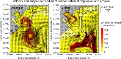
The 2011 Tohoku Tsunami induced sediment deposition of 334,000 m3 mainly in the basin and 9 m erosion at the tips of a breakwater and a groin in Oarai Port, Japan. The tsunami-induced bathymetry change was simulated using a numerical model and the simulated bathymetry change was compared with the measured one. The comparison showed that the simulated bathymetry change quantitatively agreed with the measured one including the sediment deposition and the erosion mentioned above although the erosion measured along the breakwater was not well reproduced by the model. The time series of simulated bathymetry change, water level, current and suspended sediment concentration showed that the sediment deposition in the center of the basin was mostly induced by the sediments that moved into the basin through its entrance between the breakwater and the groin and were redistributed by counterclockwise vortices. The severe erosion at the tip of the breakwater was mainly induced by the strong southward currents.
中文翻译:
日本大洗港2011年东北海啸引起的沉积和侵蚀的数值模拟
2011年东北海啸引起的沉积物沉积为334,000 m 3日本大洗港的防波堤和腹股沟末端主要是盆地内的9 m侵蚀。使用数值模型模拟了海啸引起的测深变化,并将模拟的测深变化与实测的变化进行了比较。比较结果表明,尽管模型无法很好地再现沿防波堤测得的侵蚀,但模拟的测深变化与包括上述沉积物沉积和侵蚀在内的被测侵蚀定量地吻合。模拟的测深变化,水位,水流和悬浮泥沙浓度的时间序列表明,盆地中心的泥沙沉积主要是由通过防波堤和腹股沟之间的入口进入盆地并重新分配的沉积物引起的。通过逆时针涡旋。


 京公网安备 11010802027423号