Estuarine, Coastal and Shelf Science ( IF 2.6 ) Pub Date : 2020-05-15 , DOI: 10.1016/j.ecss.2020.106789 Thomas Rossiter , Thomas Furey , Tim McCarthy , Dagmar B. Stengel
|
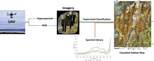
Intertidal macroalgal communities mark the boundary of the marine realm and are faced with many direct and indirect anthropogenic pressures. The effective and sustainable management of these resources must be underpinned by accurate, efficient and cost-effective environmental data collection. Traditional field survey methods, whilst accurate, are time-consuming and limited in the area that can be covered. Remote sensing permits large areas to be rapidly surveyed but the effectiveness of satellites and aircraft for mapping fine-scale intertidal macroalgal mapping is limited by their coarse spatial resolution and restricted operational flexibility. The rapid development of unoccupied aerial vehicle (UAV) and sensor technology can address these issues and provide a potential alternative to established remote sensing platforms. Here, a detailed methodology is presented for the assessment of the commercially and ecologically important intertidal brown macroalga Ascophyllum nodosum using a multirotor UAV and pushbroom hyperspectral sensor. Two different classifiers, Maximum Likelihood Classifier (MLC) and Spectral Angle Mapper (SAM), were compared along with two different sources of spectral profiles, one collected in-situ with a spectral radiometer and the other derived from hyperspectral imagery. Of the classifiers compared, both trained using image-derived spectra, MLC more accurately classified A. nodosum, and other common intertidal species and substratum (Overall Accuracy (OA) 94.7%) than SAM (OA 81.1%). In addition, SAM, trained using in-situ spectra, was the least accurate of the three classifier workflows used (OA 71.4%). The low accuracy of the spectral radiometer approach was likely due to high levels of noise present in the hyperspectral data, a result of the relative instability of the UAV platform causing vibration. The accurate mapping of non-target species also highlights the applicability of this methodology for a broader range of intertidal macroalgal species and communities. This research clearly demonstrates the potential of UAV-mounted hyperspectral remote sensing for mapping the spatially and spectral complex macroalgal habitats found within the intertidal zone.
中文翻译:
无人机安装的潮间巨藻高光谱制图
潮间带大型藻类群落标志着海洋领域的边界,并面临许多直接和间接的人为压力。这些资源的有效和可持续管理必须以准确,高效和具有成本效益的环境数据收集为基础。传统的野外勘测方法虽然准确,但是却很耗时,并且在可覆盖区域内受到限制。遥感技术可以使大面积地区得到快速勘测,但卫星和飞机进行精细的潮间带大型藻类测绘的效率受到其粗糙的空间分辨率和有限的操作灵活性的限制。无人飞行器(UAV)和传感器技术的快速发展可以解决这些问题,并为已建立的遥感平台提供潜在的替代方法。这里,使用多旋翼无人机和推扫式高光谱传感器的结节藻。比较了两个不同的分类器,最大似然分类器(MLC)和光谱角映射器(SAM),以及两个不同的光谱轮廓源,一个是用光谱辐射计现场采集的,另一个是从高光谱图像中得出的。在比较的分类器中,均使用图像衍生光谱进行训练,MLC比SAM(OA 81.1%)更准确地对结节曲霉和其他常见的潮间带物种和底层进行分类(总体准确度(OA)为94.7%)。此外,SAM经过现场培训光谱是所使用的三个分类器工作流程中最不准确的(OA 71.4%)。光谱辐射计方法的准确性低可能是由于高光谱数据中存在高水平的噪声,这是无人机平台相对不稳定导致振动的结果。非目标物种的准确定位也凸显了该方法在潮间带大型藻类物种和群落中的适用性。这项研究清楚地表明了安装无人机的高光谱遥感技术在绘制潮间带内发现的空间和光谱复杂的大型藻类栖息地方面的潜力。


 京公网安备 11010802027423号