ISPRS Journal of Photogrammetry and Remote Sensing ( IF 10.6 ) Pub Date : 2020-05-12 , DOI: 10.1016/j.isprsjprs.2020.04.021 Leena Matikainen , Kirsi Karila , Paula Litkey , Eero Ahokas , Juha Hyyppä
|
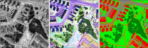
Feasibility of using single photon lidar (SPL) data for land cover classification was studied for the first time. Data from the Espoonlahti suburban study area in Finland were acquired with the SPL100 sensor from a flying altitude of 3600 m above ground level and classified into six classes using an object-based, random forest classification approach. The overall accuracy was 66% compared with a set of reference points. The results were good for buildings and trees, but there was significant confusion between ground-level land cover classes. The possibility to enhance classification accuracy by combining SPL data with multispectral intensity information from airborne laser scanning (ALS) was also tested and led to an overall accuracy of 86%. The multispectral intensity image was obtained by combining intensity data from two channels of the Optech Titan multispectral ALS sensor (infrared and near-infrared) with the SPL intensity (green). To allow for comparisons between SPL and conventional linear-mode ALS, single-channel data from the Optech Titan (near-infrared) were also applied for the same classification task. In this case, the overall accuracy was 83%. An important factor affecting the lower quality of the SPL results was the rough appearance of the intensity images created from the SPL data. Despite high point density, small features such as narrow roads were often difficult to distinguish in the intensity images. This relates to the SPL technique and preprocessing operations applied to the data. Considering future use of new ALS datasets, the different benefits of different systems need to be taken into account. A clear benefit of the SPL technique is its high efficiency in data acquisition. SPL is seemingly fit for deriving high objects that are distinguishable by using geometric rather than intensity information. The classification accuracy of buildings and trees was comparable in each classification test, although the flying altitude of the SPL100 was five times that of the Optech Titan. We propose that raw echo waveforms would be provided together with point cloud data to allow users to create their own intensity and echo width features usable for classification purposes. Combining multispectral intensity with SPL, in reference to multispectral single photon lidar, could result in a technique that is effective for mapping large areas and will also allow for automated classification of ground-level objects in a more reliable manner.
中文翻译:
结合单光子和多光谱机载激光扫描进行土地覆盖分类
首次研究了使用单光子激光雷达(SPL)数据进行土地覆盖分类的可行性。使用SPL100传感器从海拔3600 m的飞行高度获取了芬兰Espoonlahti郊区研究区的数据,并使用基于对象的随机森林分类方法将其分为六类。与一组参考点相比,整体准确性为66%。结果对建筑物和树木都很好,但是在地面土地覆盖类别之间存在明显的混淆。还测试了通过将SPL数据与来自机载激光扫描(ALS)的多光谱强度信息相结合来提高分类准确性的可能性,该方法的总体准确性为86%。多光谱强度图像是通过将来自Optech Titan多光谱ALS传感器(红外和近红外)两个通道的强度数据与SPL强度(绿色)相结合而获得的。为了在SPL和常规线性模式ALS之间进行比较,还将来自Optech Titan(近红外)的单通道数据应用于同一分类任务。在这种情况下,整体准确性为83%。影响SPL结果质量较低的一个重要因素是从SPL数据创建的强度图像的粗糙外观。尽管点密度很高,但在强度图像中通常难以区分狭窄道路等小特征。这涉及应用于数据的SPL技术和预处理操作。考虑到将来使用新的ALS数据集,需要考虑不同系统的不同好处。SPL技术的明显好处是其数据采集效率高。SPL似乎适合于导出可通过使用几何信息而不是强度信息来区分的高对象。尽管SPL100的飞行高度是Optech Titan的五倍,但在每次分类测试中建筑物和树木的分类准确度均相当。我们建议将原始回波波形与点云数据一起提供,以允许用户创建自己的强度和回波宽度特征,以用于分类目的。结合多光谱强度和SPL,参考多光谱单光子激光雷达,


 京公网安备 11010802027423号