当前位置:
X-MOL 学术
›
Earth Surf.Process. Land.
›
论文详情
Our official English website, www.x-mol.net, welcomes your
feedback! (Note: you will need to create a separate account there.)
Monitoring coastal morphology: the potential of low‐cost fixed array action cameras for 3D reconstruction
Earth Surface Processes and Landforms ( IF 2.8 ) Pub Date : 2020-06-10 , DOI: 10.1002/esp.4892 Samantha Godfrey 1 , James Cooper 1 , Frederic Bezombes 2 , Andrew Plater 1
Earth Surface Processes and Landforms ( IF 2.8 ) Pub Date : 2020-06-10 , DOI: 10.1002/esp.4892 Samantha Godfrey 1 , James Cooper 1 , Frederic Bezombes 2 , Andrew Plater 1
Affiliation
|
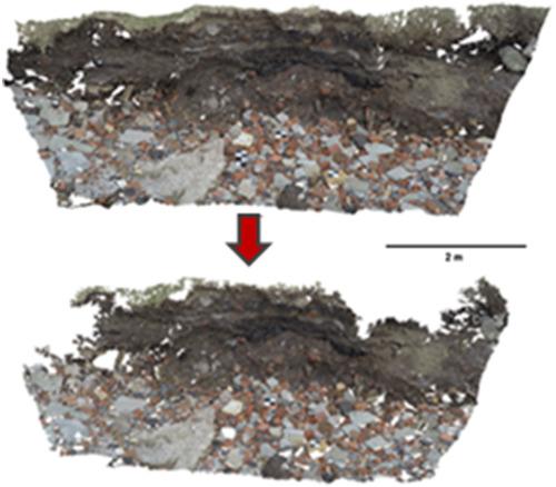
The combination of structure‐from‐motion with multi‐view stereo (SfM‐MVS) photogrammetry has become an increasingly popular method for the monitoring and three‐dimensional (3D) reconstruction of coastal environments. Climate change is driving the potential for increased coastal landward retreat meaning geomorphological monitoring using methods such as SfM‐MVS has become essential for detecting and tracking impacts. SfM‐MVS has been well‐researched with a variety of platforms and spatial and temporal resolutions using mainly rectilinear digital cameras in coastal settings. However, there has been no assessment of the potential of fixed multi‐camera arrays to monitor landward retreat or on the significance of camera placement in relation to the scene. This study presents an innovative method of image acquisition using a purpose‐built camera grid and GoPro© action camera to evaluate the combined effects of camera height, obliqueness and overlap at a site of known landward retreat. This approach examines the effect of camera placement on scene reconstruction to aid the design of a multi‐camera array. SfM‐MVS dense point clouds display millimetre accuracy when compared to equivalent terrestrial laser scans and strong image network geometry with internal precision estimates of < 3 mm. Comparable point cloud reconstruction can be achieved with a small number of images stationed in appropriate positions. Initial results show as few as five images positioned at a cliff to camera ratio of 3:4.18 and camera obliqueness of 40° can provide reconstruction in the range of millimetres (mean error of 4.79 mm). These findings illustrate the importance of camera placement when using multiple cameras and aid the design of a low‐cost, fixed multi‐camera array for use at sites of small‐scale landward retreat. © 2020 The Authors. Earth Surface Processes and Landforms published by John Wiley & Sons Ltd
中文翻译:

监测海岸形态:低成本固定阵列运动相机在3D重建中的潜力
从运动结构到多视图立体(SfM-MVS)摄影测量法的结合已成为监视和监测沿海环境的三维(3D)重建的一种越来越流行的方法。气候变化正在推动沿海陆上撤退的可能性增加,这意味着使用SfM-MVS等方法进行地貌监测已成为发现和追踪影响的必要条件。SfM-MVS在沿海地区主要使用直线型数码相机在各种平台和时空分辨率上进行了深入研究。但是,尚未评估固定多台摄像机阵列监视地面后退的潜力,也没有评估摄像机相对于场景的重要性。这项研究提出了一种创新的图像获取方法,该方法使用专用摄像机网格和GoPro©运动摄像机来评估摄像机高度,倾斜度和重叠在已知向后撤退地点的综合效果。该方法检查了摄像机放置对场景重建的影响,以帮助设计多摄像机阵列。与等效的地面激光扫描和强大的图像网络几何相比,SfM-MVS密集点云显示毫米级精度,内部精度估计值小于3 mm。可通过在适当位置放置少量图像来实现可比的点云重构。初步结果显示,以3:4.18的倾斜度与摄像机的比例和40°的摄像机倾斜度定位的影像只有5幅,可以在毫米范围内进行重建(平均误差为4)。79毫米)。这些发现说明了在使用多台摄像机时摄像机放置的重要性,并有助于设计一种低成本,固定的多摄像机阵列,以用于小规模陆上撤退地点。©2020作者。约翰·威利父子有限公司出版的《地球表面过程和地形》
更新日期:2020-06-10
中文翻译:
监测海岸形态:低成本固定阵列运动相机在3D重建中的潜力
从运动结构到多视图立体(SfM-MVS)摄影测量法的结合已成为监视和监测沿海环境的三维(3D)重建的一种越来越流行的方法。气候变化正在推动沿海陆上撤退的可能性增加,这意味着使用SfM-MVS等方法进行地貌监测已成为发现和追踪影响的必要条件。SfM-MVS在沿海地区主要使用直线型数码相机在各种平台和时空分辨率上进行了深入研究。但是,尚未评估固定多台摄像机阵列监视地面后退的潜力,也没有评估摄像机相对于场景的重要性。这项研究提出了一种创新的图像获取方法,该方法使用专用摄像机网格和GoPro©运动摄像机来评估摄像机高度,倾斜度和重叠在已知向后撤退地点的综合效果。该方法检查了摄像机放置对场景重建的影响,以帮助设计多摄像机阵列。与等效的地面激光扫描和强大的图像网络几何相比,SfM-MVS密集点云显示毫米级精度,内部精度估计值小于3 mm。可通过在适当位置放置少量图像来实现可比的点云重构。初步结果显示,以3:4.18的倾斜度与摄像机的比例和40°的摄像机倾斜度定位的影像只有5幅,可以在毫米范围内进行重建(平均误差为4)。79毫米)。这些发现说明了在使用多台摄像机时摄像机放置的重要性,并有助于设计一种低成本,固定的多摄像机阵列,以用于小规模陆上撤退地点。©2020作者。约翰·威利父子有限公司出版的《地球表面过程和地形》


 京公网安备 11010802027423号