当前位置:
X-MOL 学术
›
Earth Surf.Process. Land.
›
论文详情
Our official English website, www.x-mol.net, welcomes your
feedback! (Note: you will need to create a separate account there.)
Deep learning for dune pattern mapping with the AW3D30 global surface model
Earth Surface Processes and Landforms ( IF 2.8 ) Pub Date : 2020-05-27 , DOI: 10.1002/esp.4888 Samuel Shumack 1 , Paul Hesse 1 , Will Farebrother 1
Earth Surface Processes and Landforms ( IF 2.8 ) Pub Date : 2020-05-27 , DOI: 10.1002/esp.4888 Samuel Shumack 1 , Paul Hesse 1 , Will Farebrother 1
Affiliation
|
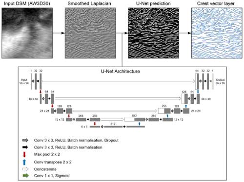
In this paper we present a deep learning (U‐Net)‐based workflow for classifying linear dune landforms based on the discrete Laplacian convolution of a new global elevation dataset, the AW3D30 digital surface model. Crest vectors were then derived for landscape pattern analysis. The U‐Net crest classification model was trained and evaluated on sample data from dunefields across the Australian continent. The resulting crest vectors and dune defect placement were then evaluated in typical semi‐arid and arid dune landscapes in eastern central Australia where high‐resolution (5 m horizontal) digital elevation models are available (for three out of our four study sites) as a reference dataset. The method was applied to quantify dune pattern metrics for the entire Simpson Desert dunefield, Australia. The U‐Net does a very good job of segmenting dune crests, even where dunes are less clear in the Laplacian map (intersection over union score ≈ 0.68). When crest vectors and dune defects (network nodes) were derived, the defect predictions were typically correct (0.4 to 0.79 correctness) but incomplete (0.02 to 0.64 completeness). Much of the residual error was traced to the resolution of the input data. Through the application to the Simpson Desert, we nevertheless demonstrated that our method can effectively be used for regional‐scale dune pattern analysis. Furthermore, we suggest that the combination of morphological filtering and a convolutional neural network could readily be adapted to target other geomorphic features, such as channel networks or geological lineaments. © 2020 John Wiley & Sons, Ltd.
中文翻译:

使用AW3D30全局曲面模型进行沙丘图案映射的深度学习
在本文中,我们介绍了一种基于深度学习(U-Net)的工作流,用于基于新的全球海拔数据集AW3D30数字表面模型的离散拉普拉斯卷积对线性沙丘地形进行分类。然后导出波峰矢量以进行景观格局分析。对U‐Net波峰分类模型进行了训练,并对来自澳大利亚大陆的沙丘油田的样本数据进行了评估。然后,在澳大利亚中部东部典型的半干旱和干旱沙丘景观中评估了最终的波峰矢量和沙丘缺陷位置,那里提供了高分辨率(水平5 m)数字高程模型(用于我们四个研究地点中的三个)作为参考数据集。该方法用于量化整个澳大利亚辛普森沙漠沙丘的沙丘模式指标。即使在拉普拉斯地图中沙丘不太清晰的地方(联合分数相交≈0.68),U-Net也能很好地分割沙丘峰。当得出波峰矢量和沙丘缺陷(网络节点)时,缺陷预测通常是正确的(正确度为0.4到0.79),但是不完整(正确度为0.02到0.64)。许多残留误差可追溯到输入数据的分辨率。通过在辛普森沙漠的应用,我们仍然证明了我们的方法可以有效地用于区域尺度的沙丘模式分析。此外,我们建议形态过滤和卷积神经网络的组合可以轻松地针对其他地貌特征,例如通道网络或地质学。分级为4 +©2020 John Wiley&Sons,Ltd. 即使在拉普拉斯地图中沙丘不太清晰的地方(联合得分相交处≈0.68)。当得出波峰矢量和沙丘缺陷(网络节点)时,缺陷预测通常是正确的(正确度为0.4到0.79),但是不完整(正确度为0.02到0.64)。许多残留误差可追溯到输入数据的分辨率。通过在辛普森沙漠的应用,我们仍然证明了我们的方法可以有效地用于区域尺度的沙丘模式分析。此外,我们建议形态过滤和卷积神经网络的组合可以轻松地针对其他地貌特征,例如通道网络或地质学。分级为4 +©2020 John Wiley&Sons,Ltd. 即使在拉普拉斯地图中沙丘不太清晰的地方(联合得分相交处≈0.68)。当得出波峰矢量和沙丘缺陷(网络节点)时,缺陷预测通常是正确的(正确度为0.4到0.79),但是不完整(正确度为0.02到0.64)。许多残留误差可追溯到输入数据的分辨率。通过在辛普森沙漠的应用,我们仍然证明了我们的方法可以有效地用于区域尺度的沙丘模式分析。此外,我们建议形态过滤和卷积神经网络的组合可以轻松地针对其他地貌特征,例如通道网络或地质学。分级为4 +©2020 John Wiley&Sons,Ltd. 当得出波峰矢量和沙丘缺陷(网络节点)时,缺陷预测通常是正确的(正确度为0.4到0.79),但是不完整(正确度为0.02到0.64)。许多残留误差可追溯到输入数据的分辨率。通过在辛普森沙漠的应用,我们仍然证明了我们的方法可以有效地用于区域尺度的沙丘模式分析。此外,我们建议形态过滤和卷积神经网络的组合可以轻松地针对其他地貌特征,例如通道网络或地质学。分级为4 +©2020 John Wiley&Sons,Ltd. 当得出波峰矢量和沙丘缺陷(网络节点)时,缺陷预测通常是正确的(正确度为0.4到0.79),但是不完整(正确度为0.02到0.64)。许多残留误差可追溯到输入数据的分辨率。通过在辛普森沙漠的应用,我们仍然证明了我们的方法可以有效地用于区域尺度的沙丘模式分析。此外,我们建议形态滤波和卷积神经网络的组合可以轻松地针对其他地貌特征,例如通道网络或地质构造。分级为4 +©2020 John Wiley&Sons,Ltd. 许多残留误差可追溯到输入数据的分辨率。通过在辛普森沙漠的应用,我们证明了我们的方法可以有效地用于区域尺度的沙丘模式分析。此外,我们建议形态滤波和卷积神经网络的组合可以轻松地针对其他地貌特征,例如通道网络或地质构造。分级为4 +©2020 John Wiley&Sons,Ltd. 许多残留误差可追溯到输入数据的分辨率。通过在辛普森沙漠的应用,我们仍然证明了我们的方法可以有效地用于区域尺度的沙丘模式分析。此外,我们建议形态滤波和卷积神经网络的组合可以轻松地针对其他地貌特征,例如通道网络或地质构造。分级为4 +©2020 John Wiley&Sons,Ltd. 例如渠道网络或地质界线。分级为4 +©2020 John Wiley&Sons,Ltd. 例如渠道网络或地质界线。分级为4 +©2020 John Wiley&Sons,Ltd.
更新日期:2020-05-27
中文翻译:
使用AW3D30全局曲面模型进行沙丘图案映射的深度学习
在本文中,我们介绍了一种基于深度学习(U-Net)的工作流,用于基于新的全球海拔数据集AW3D30数字表面模型的离散拉普拉斯卷积对线性沙丘地形进行分类。然后导出波峰矢量以进行景观格局分析。对U‐Net波峰分类模型进行了训练,并对来自澳大利亚大陆的沙丘油田的样本数据进行了评估。然后,在澳大利亚中部东部典型的半干旱和干旱沙丘景观中评估了最终的波峰矢量和沙丘缺陷位置,那里提供了高分辨率(水平5 m)数字高程模型(用于我们四个研究地点中的三个)作为参考数据集。该方法用于量化整个澳大利亚辛普森沙漠沙丘的沙丘模式指标。即使在拉普拉斯地图中沙丘不太清晰的地方(联合分数相交≈0.68),U-Net也能很好地分割沙丘峰。当得出波峰矢量和沙丘缺陷(网络节点)时,缺陷预测通常是正确的(正确度为0.4到0.79),但是不完整(正确度为0.02到0.64)。许多残留误差可追溯到输入数据的分辨率。通过在辛普森沙漠的应用,我们仍然证明了我们的方法可以有效地用于区域尺度的沙丘模式分析。此外,我们建议形态过滤和卷积神经网络的组合可以轻松地针对其他地貌特征,例如通道网络或地质学。分级为4 +©2020 John Wiley&Sons,Ltd. 即使在拉普拉斯地图中沙丘不太清晰的地方(联合得分相交处≈0.68)。当得出波峰矢量和沙丘缺陷(网络节点)时,缺陷预测通常是正确的(正确度为0.4到0.79),但是不完整(正确度为0.02到0.64)。许多残留误差可追溯到输入数据的分辨率。通过在辛普森沙漠的应用,我们仍然证明了我们的方法可以有效地用于区域尺度的沙丘模式分析。此外,我们建议形态过滤和卷积神经网络的组合可以轻松地针对其他地貌特征,例如通道网络或地质学。分级为4 +©2020 John Wiley&Sons,Ltd. 即使在拉普拉斯地图中沙丘不太清晰的地方(联合得分相交处≈0.68)。当得出波峰矢量和沙丘缺陷(网络节点)时,缺陷预测通常是正确的(正确度为0.4到0.79),但是不完整(正确度为0.02到0.64)。许多残留误差可追溯到输入数据的分辨率。通过在辛普森沙漠的应用,我们仍然证明了我们的方法可以有效地用于区域尺度的沙丘模式分析。此外,我们建议形态过滤和卷积神经网络的组合可以轻松地针对其他地貌特征,例如通道网络或地质学。分级为4 +©2020 John Wiley&Sons,Ltd. 当得出波峰矢量和沙丘缺陷(网络节点)时,缺陷预测通常是正确的(正确度为0.4到0.79),但是不完整(正确度为0.02到0.64)。许多残留误差可追溯到输入数据的分辨率。通过在辛普森沙漠的应用,我们仍然证明了我们的方法可以有效地用于区域尺度的沙丘模式分析。此外,我们建议形态过滤和卷积神经网络的组合可以轻松地针对其他地貌特征,例如通道网络或地质学。分级为4 +©2020 John Wiley&Sons,Ltd. 当得出波峰矢量和沙丘缺陷(网络节点)时,缺陷预测通常是正确的(正确度为0.4到0.79),但是不完整(正确度为0.02到0.64)。许多残留误差可追溯到输入数据的分辨率。通过在辛普森沙漠的应用,我们仍然证明了我们的方法可以有效地用于区域尺度的沙丘模式分析。此外,我们建议形态滤波和卷积神经网络的组合可以轻松地针对其他地貌特征,例如通道网络或地质构造。分级为4 +©2020 John Wiley&Sons,Ltd. 许多残留误差可追溯到输入数据的分辨率。通过在辛普森沙漠的应用,我们证明了我们的方法可以有效地用于区域尺度的沙丘模式分析。此外,我们建议形态滤波和卷积神经网络的组合可以轻松地针对其他地貌特征,例如通道网络或地质构造。分级为4 +©2020 John Wiley&Sons,Ltd. 许多残留误差可追溯到输入数据的分辨率。通过在辛普森沙漠的应用,我们仍然证明了我们的方法可以有效地用于区域尺度的沙丘模式分析。此外,我们建议形态滤波和卷积神经网络的组合可以轻松地针对其他地貌特征,例如通道网络或地质构造。分级为4 +©2020 John Wiley&Sons,Ltd. 例如渠道网络或地质界线。分级为4 +©2020 John Wiley&Sons,Ltd. 例如渠道网络或地质界线。分级为4 +©2020 John Wiley&Sons,Ltd.


 京公网安备 11010802027423号