当前位置:
X-MOL 学术
›
Urban Forestry Urban Green.
›
论文详情
Our official English website, www.x-mol.net, welcomes your
feedback! (Note: you will need to create a separate account there.)
A new index to differentiate tree and grass based on high resolution image and object-based methods
Urban Forestry & Urban Greening ( IF 6.0 ) Pub Date : 2020-08-01 , DOI: 10.1016/j.ufug.2020.126661 Yuguo Qian , Weiqi Zhou , Christopher J. Nytch , Lijian Han , Zhiqiang Li
Urban Forestry & Urban Greening ( IF 6.0 ) Pub Date : 2020-08-01 , DOI: 10.1016/j.ufug.2020.126661 Yuguo Qian , Weiqi Zhou , Christopher J. Nytch , Lijian Han , Zhiqiang Li
|
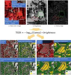
Abstract Urban trees and grass have different ecological functions and services. Remote sensing provides a feasible way of quantifying urban vegetative cover and distribution at large scale. Most previous studies have used supervised classification based on high resolution images to map urban trees and grass. However, due to the lack of specialized features for distinguishing coarse and fine vegetation, the classification accuracy of urban trees and grass is consistently low. Although adding 3D topographical information can improve accuracy, such data has limited availability. This paper developed a tree-grass differentiation index (TGDI) to facilitate the fast and effective classification of urban trees and grass. We examined the performance of the new index by applying it to different classification methods. We compared the classification of Method 1: supervised classification without TGDI; Method 2: supervised classification with TGDI; and Method 3: rule-based classification with TGDI. The results showed that the overall accuracy of Method 1, Method 2, and Method 3 were, 84 %, 88 %, and 90.5 %, respectively. Using the new index can improve the classification of urban trees and grass regardless if TGDI is used alone for rule-based classification or added as a feature for supervised classification. The main advantage of using TGDI is to reduce the misclassification of sunlit portions of trees into grass. The producer accuracy of tree and the user accuracy of grass can be improved by more than 10 % when TGDI is applied to supervised classification. This study synthesized texture and spectral features, which enhances the traditional approach of index construction based on spectral features alone, and without the requirement of detailed 3D surface data. The results suggest a novel way forward for developing indexes that can yield improved accuracies and expand the utility of remote sensing for illuminating patterns of ecological structure and function in urban environments.
中文翻译:

一种基于高分辨率图像和基于对象的方法来区分树和草的新指标
摘要 城市树木和草地具有不同的生态功能和服务。遥感为大规模量化城市植被覆盖和分布提供了一种可行的方法。以前的大多数研究都使用基于高分辨率图像的监督分类来绘制城市树木和草地的地图。然而,由于缺乏区分粗细植被的专门特征,城市树木和草地的分类精度一直较低。尽管添加 3D 地形信息可以提高准确性,但此类数据的可用性有限。本文开发了一种树草分化指数(TGDI),以促进城市树木和草的快速有效分类。我们通过将新指数应用于不同的分类方法来检查它的性能。我们比较了方法一的分类:没有TGDI的监督分类;方法二:TGDI监督分类;方法 3:基于规则的分类与 TGDI。结果表明,方法1、方法2和方法3的总体准确度分别为84%、88%和90.5%。无论是单独使用 TGDI 进行基于规则的分类还是添加作为监督分类的特征,使用新索引都可以改进城市树木和草地的分类。使用 TGDI 的主要优点是减少将树木的阳光照射部分误分类为草的情况。当TGDI应用于监督分类时,树的生产者准确率和草的用户准确率可以提高10%以上。本研究综合了纹理和光谱特征,它增强了传统的仅基于光谱特征的索引构建方法,不需要详细的 3D 表面数据。结果提出了一种开发指标的新方法,可以提高精度并扩大遥感在城市环境中生态结构和功能模式的照明应用。
更新日期:2020-08-01
中文翻译:
一种基于高分辨率图像和基于对象的方法来区分树和草的新指标
摘要 城市树木和草地具有不同的生态功能和服务。遥感为大规模量化城市植被覆盖和分布提供了一种可行的方法。以前的大多数研究都使用基于高分辨率图像的监督分类来绘制城市树木和草地的地图。然而,由于缺乏区分粗细植被的专门特征,城市树木和草地的分类精度一直较低。尽管添加 3D 地形信息可以提高准确性,但此类数据的可用性有限。本文开发了一种树草分化指数(TGDI),以促进城市树木和草的快速有效分类。我们通过将新指数应用于不同的分类方法来检查它的性能。我们比较了方法一的分类:没有TGDI的监督分类;方法二:TGDI监督分类;方法 3:基于规则的分类与 TGDI。结果表明,方法1、方法2和方法3的总体准确度分别为84%、88%和90.5%。无论是单独使用 TGDI 进行基于规则的分类还是添加作为监督分类的特征,使用新索引都可以改进城市树木和草地的分类。使用 TGDI 的主要优点是减少将树木的阳光照射部分误分类为草的情况。当TGDI应用于监督分类时,树的生产者准确率和草的用户准确率可以提高10%以上。本研究综合了纹理和光谱特征,它增强了传统的仅基于光谱特征的索引构建方法,不需要详细的 3D 表面数据。结果提出了一种开发指标的新方法,可以提高精度并扩大遥感在城市环境中生态结构和功能模式的照明应用。


 京公网安备 11010802027423号