Estuarine, Coastal and Shelf Science ( IF 2.6 ) Pub Date : 2020-05-04 , DOI: 10.1016/j.ecss.2020.106792 C. Viswanathan , R. Purvaja , J. Joyson Joe Jeevamani , V. Deepak Samuel , R. Sankar , K.R. Abhilash , Gejo Anna Geevarghese , R. Muruganandam , M. Gopi , S. Raja , Rocktim Ramen Das , Shesdev Patro , P. Krishnan , R. Ramesh
|
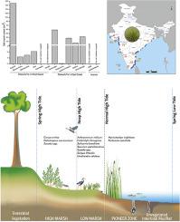
Salt marshes are one among the most productive coastal ecosystems, mostly confined to low-energy coasts of temperate and high latitude. Tropical and sub-tropical salt marshes are generally less studied. The present study attempts to assess the status of salt marsh vegetation along the Indian coast regarding its species composition, density, and zonation pattern. Satellite images were used to map salt marshes along the coastal region and to perform field surveys for status assessment at selected sites between November 2014 and July 2018. The total extent of salt marshes in India is estimated as about 290 km2. A total of 14 salt marsh species are found distributed along the Indian coast, belonging to 11 genera under six families. The most diverse family is represented by Amaranthaceae. The overall mean density of salt marsh vegetation is estimated to be 19 ± 1 plants per m2 with the highest density recorded in Lakshadweep (28 m−2) followed by Tamil Nadu (23 m−2), West Bengal (19 m−2), Maharashtra (18 m−2), Andhra Pradesh (17 m−2), Gujarat (15 m−2) and Puducherry (10 m−2). The zonation pattern of salt marsh vegetation in pure stands is detailed from observations. Conservation implications on salt marshes have been discussed. This study provides insight into salt marshes in the tropical environment.
中文翻译:
印度盐沼植被:物种组成,分布,分区模式和保护意义
盐沼是生产力最高的沿海生态系统之一,大多局限于温带和高纬度的低能海岸。通常较少研究热带和亚热带盐沼。本研究试图评估印度海岸沿线盐沼植被的种类组成,密度和分区模式。在2014年11月至2018年7月之间,使用卫星图像绘制了沿海地区的盐沼地图,并进行了现场调查,以评估特定地点的状况。印度盐沼的总面积估计约为290 km 2。在印度海岸沿线共发现了14种盐沼物种,属于6个科的11属。diverse菜科代表着最多样化的家庭。盐沼植被的总体平均密度估计为每m 2 19±1株,其中最高密度记录在Lakshadweep(28 m -2),其次是Tamil Nadu(23 m -2),西孟加拉邦(19 m -2)。),马哈拉施特拉邦(18 m -2),安得拉邦(17 m -2),古吉拉特邦(15 m -2)和Puducherry(10 m -2)。根据观测结果,可以详细了解纯林中盐沼植被的分区模式。已经讨论了盐沼的保护意义。这项研究提供了对热带环境中盐沼的见解。


 京公网安备 11010802027423号