当前位置:
X-MOL 学术
›
Meteorol. Appl.
›
论文详情
Our official English website, www.x-mol.net, welcomes your feedback! (Note: you will need to create a separate account there.)
Simulation of the atmospheric parameters during passage of a tropical storm over the South China Sea: a comparison with MetOcean buoy and ERA‐Interim data
Meteorological Applications ( IF 2.7 ) Pub Date : 2020-03-05 , DOI: 10.1002/met.1895 Sivaprasad P 1 , Azizan Abu Samah 1 , C. A Babu 2 , Yue Fang 3 , Mohd Fadzil Firdzaus Mohd Nor 1 , Sheeba Nettukandy Chenoli 4 , Wee Cheah 1 , Muhammad Yunus Ahmad Mazuki 1
Meteorological Applications ( IF 2.7 ) Pub Date : 2020-03-05 , DOI: 10.1002/met.1895 Sivaprasad P 1 , Azizan Abu Samah 1 , C. A Babu 2 , Yue Fang 3 , Mohd Fadzil Firdzaus Mohd Nor 1 , Sheeba Nettukandy Chenoli 4 , Wee Cheah 1 , Muhammad Yunus Ahmad Mazuki 1
Affiliation
|
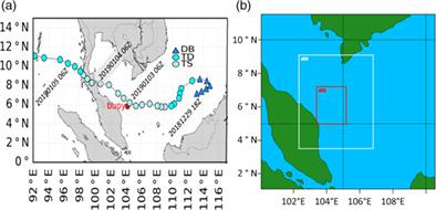
The accuracy of Weather Research and Forecasting (WRF) model derived meteorological fields during the passage of a tropical storm, Pabuk, over the southern South China Sea is investigated. The European Centre for Medium‐Range Weather Forecasts’ ERA‐Interim data were also used for comparison. Data from a MetOcean buoy which captured tropical storm Pabuk were used to evaluate the accuracy of the WRF model. The period of study was from January 1, 2019 to January 5, 2019. Simulated parameters (surface temperature, wind speed and pressure) showed agreement with the buoy data before and after passage of the tropical storm. In contrast, model output shows differences from observations during the passage of the storm near 0600 UTC on January 3, 2019. Overall, surface pressure was simulated with a maximum correlation of 0.93 while the wind speed showed a minimum correlation of 0.76. The surface temperature was simulated with a correlation of 0.78. Weaker correlations arise due to differences in simulated and observed parameters during the storm. During the storm, model estimates overestimated the buoy wind speed and pressure data. The results show the inaccuracy of the simulation due to the vigorous conditions prevailing during the storm. The location of the centre of the storm differing between the model and the ERA‐Interim data could also contribute to the discrepancy of the WRF data. The MetOcean buoy provided a rare opportunity for validation of the WRF model during the storm over the understudied shallow tropical South China Sea.
中文翻译:

南海热带风暴通过期间的大气参数模拟:与MetOcean浮标和ERA-Interim数据的比较
研究了南海南部热带风暴Pabuk穿越期间由天气研究与预报(WRF)模型得出的气象场的准确性。欧洲中距离天气预报中心的ERA中期数据也用于比较。来自捕获热带风暴帕布克的MetOcean浮标的数据用于评估WRF模型的准确性。研究期间为2019年1月1日至2019年1月5日。模拟参数(地表温度,风速和压力)显示与热带风暴通过前后的浮标数据一致。相比之下,模型输出显示与2019年1月3日0600 UTC附近的风暴通过期间的观测结果有所不同。总体而言,模拟的表面压力的最大相关值为0。93,而风速的最小相关系数为0.76。表面温度的相关系数为0.78。由于风暴期间模拟参数和观测参数的差异,相关性减弱。在暴风雨期间,模型估计高估了浮标的风速和压力数据。结果表明,由于暴风雨期间的剧烈条件,模拟不准确。风暴中心的位置在模型和ERA-Interim数据之间也不同,这也可能导致WRF数据出现差异。MetOcean浮标提供了一个难得的机会,可在被研究不足的热带浅海南海风暴期间验证WRF模型。由于风暴期间模拟参数和观测参数的差异,相关性减弱。在暴风雨期间,模型估计高估了浮标的风速和压力数据。结果表明,由于暴风雨期间的剧烈条件,模拟不准确。风暴中心的位置在模型和ERA-Interim数据之间也不同,这也可能导致WRF数据出现差异。MetOcean浮标提供了一个难得的机会,可在被研究不足的热带浅海南海风暴期间验证WRF模型。由于风暴期间模拟参数和观测参数的差异,相关性减弱。在暴风雨期间,模型估计高估了浮标的风速和压力数据。结果表明,由于暴风雨期间的剧烈条件,模拟不准确。风暴中心的位置在模型和ERA-Interim数据之间也不同,这也可能导致WRF数据出现差异。MetOcean浮标提供了一个难得的机会,可在被研究不足的热带浅海南海风暴期间验证WRF模型。风暴中心的位置在模型和ERA-Interim数据之间也不同,这也可能导致WRF数据出现差异。MetOcean浮标提供了一个难得的机会,可在被研究不足的热带浅海南海风暴期间验证WRF模型。风暴中心的位置在模型和ERA-Interim数据之间也不同,这也可能导致WRF数据出现差异。MetOcean浮标提供了一个难得的机会,可在被研究不足的热带浅海南海风暴期间验证WRF模型。
更新日期:2020-03-05
中文翻译:
南海热带风暴通过期间的大气参数模拟:与MetOcean浮标和ERA-Interim数据的比较
研究了南海南部热带风暴Pabuk穿越期间由天气研究与预报(WRF)模型得出的气象场的准确性。欧洲中距离天气预报中心的ERA中期数据也用于比较。来自捕获热带风暴帕布克的MetOcean浮标的数据用于评估WRF模型的准确性。研究期间为2019年1月1日至2019年1月5日。模拟参数(地表温度,风速和压力)显示与热带风暴通过前后的浮标数据一致。相比之下,模型输出显示与2019年1月3日0600 UTC附近的风暴通过期间的观测结果有所不同。总体而言,模拟的表面压力的最大相关值为0。93,而风速的最小相关系数为0.76。表面温度的相关系数为0.78。由于风暴期间模拟参数和观测参数的差异,相关性减弱。在暴风雨期间,模型估计高估了浮标的风速和压力数据。结果表明,由于暴风雨期间的剧烈条件,模拟不准确。风暴中心的位置在模型和ERA-Interim数据之间也不同,这也可能导致WRF数据出现差异。MetOcean浮标提供了一个难得的机会,可在被研究不足的热带浅海南海风暴期间验证WRF模型。由于风暴期间模拟参数和观测参数的差异,相关性减弱。在暴风雨期间,模型估计高估了浮标的风速和压力数据。结果表明,由于暴风雨期间的剧烈条件,模拟不准确。风暴中心的位置在模型和ERA-Interim数据之间也不同,这也可能导致WRF数据出现差异。MetOcean浮标提供了一个难得的机会,可在被研究不足的热带浅海南海风暴期间验证WRF模型。由于风暴期间模拟参数和观测参数的差异,相关性减弱。在暴风雨期间,模型估计高估了浮标的风速和压力数据。结果表明,由于暴风雨期间的剧烈条件,模拟不准确。风暴中心的位置在模型和ERA-Interim数据之间也不同,这也可能导致WRF数据出现差异。MetOcean浮标提供了一个难得的机会,可在被研究不足的热带浅海南海风暴期间验证WRF模型。风暴中心的位置在模型和ERA-Interim数据之间也不同,这也可能导致WRF数据出现差异。MetOcean浮标提供了一个难得的机会,可在被研究不足的热带浅海南海风暴期间验证WRF模型。风暴中心的位置在模型和ERA-Interim数据之间也不同,这也可能导致WRF数据出现差异。MetOcean浮标提供了一个难得的机会,可在被研究不足的热带浅海南海风暴期间验证WRF模型。


 京公网安备 11010802027423号