当前位置:
X-MOL 学术
›
J. Afr. Earth Sci.
›
论文详情
Our official English website, www.x-mol.net, welcomes your
feedback! (Note: you will need to create a separate account there.)
Assessment of urban groundwater vulnerability in arid areas: Case of Sidi Bouzid aquifer (central Tunisia)
Journal of African Earth Sciences ( IF 2.2 ) Pub Date : 2020-08-01 , DOI: 10.1016/j.jafrearsci.2020.103849 Gammoudi Safa , Chkir Najiba , Boughattas Nour El Houda , Hamdi Monji , Arraouadi Soumaya , Zouari Kamel
Journal of African Earth Sciences ( IF 2.2 ) Pub Date : 2020-08-01 , DOI: 10.1016/j.jafrearsci.2020.103849 Gammoudi Safa , Chkir Najiba , Boughattas Nour El Houda , Hamdi Monji , Arraouadi Soumaya , Zouari Kamel
|
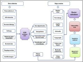
Abstract Rapid urbanization has several adverse repercussions on the hydrological cycle due to great demands of land and water for housing, transport, health, agriculture, education etc. This paper investigates the impact of the urbanization on the groundwater regime in Sidi Bouzid, an old city located in Central Tunisia under a semi-arid climate where groundwater is the sole source for water needs of the city and the surrounding farming areas. The groundwater vulnerability has been evaluated using the DRASTIC model under a GIS environment. This well-known model is based on the combination of seven parameters, Depth to water, net Recharge, Aquifer media, Soil media, Topography, Impact of vadose zone, and hydraulic Conductivity, that are considered as directly controlling the vulnerability of groundwater to potential risks. However, the original model does not consider the effect of urban land uses (urban sprawl and density) on groundwater so a modified DRASTICU model, that includes Urban land use as an eighth parameter has been applied. The net recharge assessment was also modified to include the contribution of leakages from water supply network and sewage networks to the aquifer recharge. On the other hand, soil classes of the aquifer and the vadose zone that are not included in the original listing of the model have been discussed and rated. Sensitivity analysis has been carried out to evaluate the effect of each individual parameter on the vulnerability zoning and to validate the use of each one. The validation of the DRASTICU model was done through the comparison between groundwater vulnerability index and nitrate concentrations. The vulnerability map shows that all the groundwater underlying the city is exposed to pollution risks with vulnerability index varying between extreme in the centre of the city (38%), very high in eastern parts (33.6%) and high (28.4%) elsewhere.
中文翻译:

干旱地区城市地下水脆弱性评估:Sidi Bouzid 含水层案例(突尼斯中部)
摘要 由于住房、交通、卫生、农业、教育等对土地和水资源的巨大需求,快速城市化对水文循环产生了一些不利影响。本文研究了城市化对旧城西迪布济德地下水状况的影响。位于突尼斯中部,处于半干旱气候下,地下水是城市和周边农业区用水的唯一来源。地下水脆弱性已在 GIS 环境下使用 DRASTIC 模型进行评估。这个著名的模型基于水深度、净补给、含水层介质、土壤介质、地形、包气带影响和导水率七个参数的组合,这些参数被认为直接控制地下水对潜在水势的脆弱性。风险。然而,原始模型没有考虑城市土地利用(城市扩张和密度)对地下水的影响,因此应用了修改后的 DRASTICU 模型,其中包括城市土地利用作为第八个参数。净补给评估也进行了修改,以包括供水网络和污水网络的泄漏对含水层补给的贡献。另一方面,对模型原始列表中未包括的含水层和包气带的土壤类别进行了讨论和评级。已经进行了敏感性分析以评估每个参数对脆弱性分区的影响并验证每个参数的使用。DRASTICU 模型的验证是通过地下水脆弱性指数和硝酸盐浓度之间的比较来完成的。
更新日期:2020-08-01
中文翻译:
干旱地区城市地下水脆弱性评估:Sidi Bouzid 含水层案例(突尼斯中部)
摘要 由于住房、交通、卫生、农业、教育等对土地和水资源的巨大需求,快速城市化对水文循环产生了一些不利影响。本文研究了城市化对旧城西迪布济德地下水状况的影响。位于突尼斯中部,处于半干旱气候下,地下水是城市和周边农业区用水的唯一来源。地下水脆弱性已在 GIS 环境下使用 DRASTIC 模型进行评估。这个著名的模型基于水深度、净补给、含水层介质、土壤介质、地形、包气带影响和导水率七个参数的组合,这些参数被认为直接控制地下水对潜在水势的脆弱性。风险。然而,原始模型没有考虑城市土地利用(城市扩张和密度)对地下水的影响,因此应用了修改后的 DRASTICU 模型,其中包括城市土地利用作为第八个参数。净补给评估也进行了修改,以包括供水网络和污水网络的泄漏对含水层补给的贡献。另一方面,对模型原始列表中未包括的含水层和包气带的土壤类别进行了讨论和评级。已经进行了敏感性分析以评估每个参数对脆弱性分区的影响并验证每个参数的使用。DRASTICU 模型的验证是通过地下水脆弱性指数和硝酸盐浓度之间的比较来完成的。


 京公网安备 11010802027423号