当前位置:
X-MOL 学术
›
Trans. Emerg. Telecommun. Technol.
›
论文详情
Our official English website, www.x-mol.net, welcomes your
feedback! (Note: you will need to create a separate account there.)
Revamping land coverage analysis using aerial satellite image mapping
Transactions on Emerging Telecommunications Technologies ( IF 2.5 ) Pub Date : 2020-03-30 , DOI: 10.1002/ett.3927 Gowtham Rajmohan 1 , Chandru Vignesh Chinnappan 2 , Alfred Daniel John William 2 , Sivaparthipan Chandrakrishan Balakrishnan 2 , Bala Anand Muthu 3 , Gunasekaran Manogaran 4
Transactions on Emerging Telecommunications Technologies ( IF 2.5 ) Pub Date : 2020-03-30 , DOI: 10.1002/ett.3927 Gowtham Rajmohan 1 , Chandru Vignesh Chinnappan 2 , Alfred Daniel John William 2 , Sivaparthipan Chandrakrishan Balakrishnan 2 , Bala Anand Muthu 3 , Gunasekaran Manogaran 4
Affiliation
|
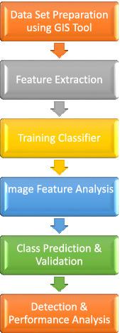
The customary terrestrial survey involves direct measurement of the land dimension in a particular area. The information accuracy of land dimension changes person to person in the existing method. Moreover, it consumes more time to conduct an assessment and produces a precise outcome. Hence, Remote Sensing offers an effective solution for accurate measurement using the Land Satellite Image Mapping with Geographic Positioning System (GPS) values. Therefore, the proposed model concentrates on the analysis of the object using Landsat Image through categorization based on the field cover analysis. The Geographic Information System (GIS) facilitates convenient measurement to determine the land dimension along with Georeferential tag. In addition to that, the features of each object are preprocessed to reduce the noise and the acquired information is stored in the classifier. Also, the features are trained using 2-fold validation, which will improve efficiency during detection. Finally, the soft hyperplane discriminators of Gaussian produce better separation accuracy compared to feature classes and object prediction. Furthermore, the Bag of feature model performance is improved by working on Hue, Saturation, and Intensity color map with multifeatured extractions on the sample images. The proposed model was trained with 1800 image samples of various land covers. On testing, the classifiers aggregate 91.4% accuracy on cross-evaluation between true class and predicted class using medium Gaussian Support Vector Machine.
中文翻译:

使用航空卫星图像映射改造土地覆盖分析
惯常的陆地测量涉及对特定区域的土地尺寸的直接测量。现有方法中土地维度的信息准确性因人而异。此外,它花费更多的时间来进行评估并产生精确的结果。因此,遥感提供了一种使用带有地理定位系统 (GPS) 值的陆地卫星图像映射进行精确测量的有效解决方案。因此,所提出的模型专注于通过基于字段覆盖分析的分类使用 Landsat Image 对对象进行分析。地理信息系统 (GIS) 有助于方便地测量以确定土地尺寸以及地理参考标记。在此之上,对每个对象的特征进行预处理以降低噪声,并将获取的信息存储在分类器中。此外,特征使用 2-fold 验证进行训练,这将提高检测过程中的效率。最后,与特征类和对象预测相比,高斯的软超平面鉴别器产生更好的分离精度。此外,通过对样本图像进行多特征提取处理色相、饱和度和强度颜色图,提高了特征模型的性能。提出的模型用 1800 个不同土地覆盖的图像样本进行了训练。在测试中,分类器使用中等高斯支持向量机在真实类和预测类之间的交叉评估中聚合了 91.4% 的准确度。这将提高检测过程中的效率。最后,与特征类和对象预测相比,高斯的软超平面鉴别器产生更好的分离精度。此外,通过对样本图像进行多特征提取处理色相、饱和度和强度颜色图,提高了特征模型的性能。提出的模型用 1800 个不同土地覆盖的图像样本进行了训练。在测试中,分类器使用中等高斯支持向量机在真实类和预测类之间的交叉评估中聚合了 91.4% 的准确度。这将提高检测过程中的效率。最后,与特征类和对象预测相比,高斯的软超平面鉴别器产生更好的分离精度。此外,通过对样本图像进行多特征提取处理色相、饱和度和强度颜色图,提高了特征模型的性能。提出的模型用 1800 个不同土地覆盖的图像样本进行了训练。在测试中,分类器使用中等高斯支持向量机在真实类和预测类之间的交叉评估中聚合了 91.4% 的准确度。通过对样本图像进行多特征提取处理色相、饱和度和强度颜色图,提高了特征模型的性能。提出的模型用 1800 个不同土地覆盖的图像样本进行了训练。在测试中,分类器使用中等高斯支持向量机在真实类和预测类之间的交叉评估中聚合了 91.4% 的准确度。通过对样本图像进行多特征提取处理色相、饱和度和强度颜色图,提高了特征模型的性能。提出的模型用 1800 个不同土地覆盖的图像样本进行了训练。在测试中,分类器使用中等高斯支持向量机在真实类和预测类之间的交叉评估中聚合了 91.4% 的准确度。
更新日期:2020-03-30
中文翻译:
使用航空卫星图像映射改造土地覆盖分析
惯常的陆地测量涉及对特定区域的土地尺寸的直接测量。现有方法中土地维度的信息准确性因人而异。此外,它花费更多的时间来进行评估并产生精确的结果。因此,遥感提供了一种使用带有地理定位系统 (GPS) 值的陆地卫星图像映射进行精确测量的有效解决方案。因此,所提出的模型专注于通过基于字段覆盖分析的分类使用 Landsat Image 对对象进行分析。地理信息系统 (GIS) 有助于方便地测量以确定土地尺寸以及地理参考标记。在此之上,对每个对象的特征进行预处理以降低噪声,并将获取的信息存储在分类器中。此外,特征使用 2-fold 验证进行训练,这将提高检测过程中的效率。最后,与特征类和对象预测相比,高斯的软超平面鉴别器产生更好的分离精度。此外,通过对样本图像进行多特征提取处理色相、饱和度和强度颜色图,提高了特征模型的性能。提出的模型用 1800 个不同土地覆盖的图像样本进行了训练。在测试中,分类器使用中等高斯支持向量机在真实类和预测类之间的交叉评估中聚合了 91.4% 的准确度。这将提高检测过程中的效率。最后,与特征类和对象预测相比,高斯的软超平面鉴别器产生更好的分离精度。此外,通过对样本图像进行多特征提取处理色相、饱和度和强度颜色图,提高了特征模型的性能。提出的模型用 1800 个不同土地覆盖的图像样本进行了训练。在测试中,分类器使用中等高斯支持向量机在真实类和预测类之间的交叉评估中聚合了 91.4% 的准确度。这将提高检测过程中的效率。最后,与特征类和对象预测相比,高斯的软超平面鉴别器产生更好的分离精度。此外,通过对样本图像进行多特征提取处理色相、饱和度和强度颜色图,提高了特征模型的性能。提出的模型用 1800 个不同土地覆盖的图像样本进行了训练。在测试中,分类器使用中等高斯支持向量机在真实类和预测类之间的交叉评估中聚合了 91.4% 的准确度。通过对样本图像进行多特征提取处理色相、饱和度和强度颜色图,提高了特征模型的性能。提出的模型用 1800 个不同土地覆盖的图像样本进行了训练。在测试中,分类器使用中等高斯支持向量机在真实类和预测类之间的交叉评估中聚合了 91.4% 的准确度。通过对样本图像进行多特征提取处理色相、饱和度和强度颜色图,提高了特征模型的性能。提出的模型用 1800 个不同土地覆盖的图像样本进行了训练。在测试中,分类器使用中等高斯支持向量机在真实类和预测类之间的交叉评估中聚合了 91.4% 的准确度。


 京公网安备 11010802027423号