ISPRS Journal of Photogrammetry and Remote Sensing ( IF 10.6 ) Pub Date : 2020-04-29 , DOI: 10.1016/j.isprsjprs.2020.04.012 Sugandh Chauhan , Roshanak Darvishzadeh , Mirco Boschetti , Andrew Nelson
|
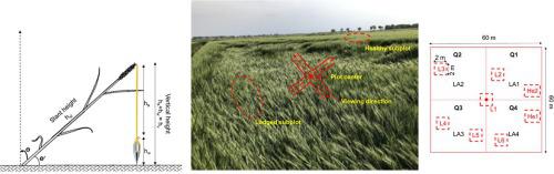
Crop lodging - the bending of crop stems from their upright position or the failure of root-soil anchorage systems - is a major yield-reducing factor in wheat and causes deterioration of grain quality. The severity of lodging can be measured by a lodging score (LS)- an index calculated from the crop angle of inclination (CAI) and crop lodged area (LA). LS is difficult and time consuming to measure manually meaning that information on lodging occurrence and severity is limited and sparse. Remote sensing-based estimates of LS can provide more timely, synoptic and reliable information on crop lodging across vast areas. This information could improve estimates of crop yield losses, inform insurance loss adjusters and influence management decisions for subsequent seasons.
This research - conducted in the 600 ha wheat sown area in the Bonifiche Ferraresi farm, located in Jolanda di Savoia, Ferrara, Italy - evaluated the performance of RADARSAT-2 and Sentinel-1 data to discriminate and classify lodging severity based on field measured LS. We measured temporal crop status characteristics related to lodging (e.g. lodged area, CAI, crop height) and collected relevant meteorological data (wind speed and rainfall) throughout May-June 2018. These field measurements were used to distinguish healthy (He) wheat from lodged wheat with different degrees of lodging severity (moderate, severe and very severe). We acquired multi-incidence angle (FQ8-27° and FQ21-41°) RADARSAT-2 and Sentinel-1 (40°) images and derived multiple metrics from them to discriminate and classify lodging severity. As a part of our data exploration, we performed a correlation analysis between the image-based metrics and LS. Next, a multi-temporal discriminant analysis approach, including a partial least squares (PLS-DA) method, was developed to classify lodging severities. We used the area under the curve-receiver operating characteristics (AUC-ROC) and confusion matrices to evaluate the accuracy of the PLS-DA classification models.
Results show that (1) volume scattering components were highly correlated with LS at low incidence angles while double and surface scattering was more prevalent at high incidence angles; (2) lodging severity was best classified using low incidence angle R-FQ8 data (overall accuracy 72%) and (3) the Sentinel-1 data-based classification model was able to correctly identify 60% of the lodging severity cases in the study site. The results from this first study on classifying lodging severity using satellite-based SAR platforms suggests that SAR-based metrics can capture a substantial proportion of the observed variation in lodging severity, which is important in the context of operational crop lodging assessment in particular, and sustainable agriculture in general.
中文翻译:
基于RADARSAT-2和Sentinel-1数据的小麦倒伏严重性分类判别分析
作物倒伏-作物因直立姿势而弯曲或根系土壤锚固系统失效-是造成小麦减产的主要因素,并导致谷物品质下降。倒伏的严重程度可以通过倒伏分数(LS)来衡量,倒伏分数是根据作物倾斜角(CAI)和作物倒伏面积(LA)计算得出的指数。LS难以手动测量且耗时,这意味着有关倒伏发生和严重性的信息有限且稀疏。基于遥感的LS估计值可以提供有关广大地区农作物倒伏的更多及时,概要和可靠的信息。该信息可以改善对作物单产损失的估计,为保险损失调整者提供信息,并影响后续季节的管理决策。
这项研究是在意大利费拉拉的Jolanda di Savoia的Bonifiche Ferraresi农场的600公顷小麦播种区进行的,评估了RADARSAT-2和Sentinel-1数据的性能,以根据实地测得的LS判别和分类倒伏严重性。我们测量了与倒伏有关的暂时作物状况特征(例如,倒伏面积,CAI,作物高度),并收集了整个2018年5月至6月的相关气象数据(风速和降雨量)。这些田间测量用于区分健康(He)小麦小麦倒伏程度不同(中等,严重和非常严重)。我们获取了多入射角(FQ8-27°和FQ21-41°)的RADARSAT-2和Sentinel-1(40°)图像,并从中得出了多个度量标准,以区分和分类倒伏严重性。作为我们数据探索的一部分,我们在基于图像的指标和LS之间进行了相关分析。接下来,开发了一种多时间判别分析方法,包括偏最小二乘(PLS-DA)方法,以对倒伏严重程度进行分类。我们使用曲线接收器工作特征(AUC-ROC)和混淆矩阵下的面积来评估PLS-DA分类模型的准确性。
结果表明:(1)在低入射角时,体积散射分量与LS高度相关,而在高入射角时,体积散射分量和表面散射更普遍。(2)使用低入射角R-FQ8数据(整体准确度为72%)对倒伏严重程度进行最佳分类,并且(3)基于Sentinel-1数据的分类模型能够正确识别研究中60%的倒伏严重病例现场。这项关于使用基于卫星的SAR平台对倒伏严重程度进行分类的第一项研究的结果表明,基于SAR的度量标准可以捕获所观察到的倒伏严重程度的很大一部分,这在进行农作物倒伏评估的情况下尤其重要,并且可持续农业。


 京公网安备 11010802027423号