当前位置:
X-MOL 学术
›
J. Asian Earth Sci.
›
论文详情
Our official English website, www.x-mol.net, welcomes your feedback! (Note: you will need to create a separate account there.)
Seismic velocity structure beneath the Western Solomon Islands from the joint inversion of receiver functions and surface-wave dispersion curves
Journal of Asian Earth Sciences ( IF 3 ) Pub Date : 2020-06-01 , DOI: 10.1016/j.jseaes.2020.104378 Chin-Shang Ku , Yu-Ting Kuo , Bor-Shouh Huang , Yue-Gau Chen , Yih-Min Wu
Journal of Asian Earth Sciences ( IF 3 ) Pub Date : 2020-06-01 , DOI: 10.1016/j.jseaes.2020.104378 Chin-Shang Ku , Yu-Ting Kuo , Bor-Shouh Huang , Yue-Gau Chen , Yih-Min Wu
|
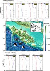
Abstract An MW 8.1 earthquake occurred in 2007 and induced a tsunami that hit the Western Solomon Islands and caused casualties. This motivated us to deploy a seismic network around the rupture zone of the 2007 event. To investigate the seismic velocity structure of the Western Solomon Islands, we select seismograms of teleseismic events recorded by our seismic network. Joint inversion of P-wave receiver functions and surface-wave group velocity dispersion curves is used to estimate station-based 1-D velocity models. The resulting velocity models show a highly variable crustal structure across the region. The Moho depths beneath the stations range from 25 to 40 km. A low-velocity zone (LVZ) is observed at most seismic stations in this work. Our study provides preliminary station-based seismic velocity models for the study region, and more stations will be deployed in the continuing project. An integrated 3-D velocity model will be determined in the future.
中文翻译:

接收函数和面波频散曲线联合反演得到的西所罗门群岛地震速度结构
摘要 2007 年发生了 8.1 兆瓦的地震并引发了海啸,袭击了西所罗门群岛并造成人员伤亡。这促使我们在 2007 年事件的破裂带周围部署地震网络。为了研究西所罗门群岛的地震速度结构,我们选择了我们的地震台网记录的远震事件的地震图。P波接收器函数和面波群速度频散曲线的联合反演用于估计基于站的一维速度模型。由此产生的速度模型显示了整个地区的高度可变的地壳结构。车站下方的莫霍面深度为 25 至 40 公里。在这项工作中,大多数地震台站都观测到一个低速带(LVZ)。我们的研究为研究区域提供了基于台站的初步地震速度模型,在后续项目中将部署更多站点。未来将确定集成的 3-D 速度模型。
更新日期:2020-06-01
中文翻译:
接收函数和面波频散曲线联合反演得到的西所罗门群岛地震速度结构
摘要 2007 年发生了 8.1 兆瓦的地震并引发了海啸,袭击了西所罗门群岛并造成人员伤亡。这促使我们在 2007 年事件的破裂带周围部署地震网络。为了研究西所罗门群岛的地震速度结构,我们选择了我们的地震台网记录的远震事件的地震图。P波接收器函数和面波群速度频散曲线的联合反演用于估计基于站的一维速度模型。由此产生的速度模型显示了整个地区的高度可变的地壳结构。车站下方的莫霍面深度为 25 至 40 公里。在这项工作中,大多数地震台站都观测到一个低速带(LVZ)。我们的研究为研究区域提供了基于台站的初步地震速度模型,在后续项目中将部署更多站点。未来将确定集成的 3-D 速度模型。


 京公网安备 11010802027423号