ISPRS Journal of Photogrammetry and Remote Sensing ( IF 10.6 ) Pub Date : 2020-04-27 , DOI: 10.1016/j.isprsjprs.2020.04.004 Eslam Ali , Wenbin Xu , Xiaoli Ding
|
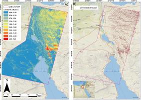
Sand dune migration poses a potential threat to desert infrastructure, vegetation, and atmospheric conditions. Capturing the patterns of long-term dune migration is useful for predicting probable desertification issues and wind conditions across vast desert areas. In this study, we employed optical image matching and a singular value decomposition approach to estimate the rates of dune migration in the North Sinai Sand Sea using the free Landsat 8 and Sentinel-2 archives. Our optical image matching time-series selection and inversion (OPTSI) algorithm limited the difference in the solar illumination of correlated pairs to decrease shadows and seasonal variability. We found that the maximum annual dune migration rates were 9.4 m/a and 15.9 m/a for Landsat 8 and Sentinel-2 data, respectively, and the results of time-series analysis revealed the existence of seasonal variations in dune migration controlled by wind regimes. The directions of sand movement extracted from the mean velocity solution agreed strongly with each other and with the drift directions estimated using wind data from meteorological stations. We assessed the uncertainty of each solution based on the variance of stable areas. Our results showed that the proposed inversion decreased uncertainty by up to 25% and increased the spatial coverage by up to 20%. This algorithm is also promising for the retrieval of historical time series on the ground displacements of glaciers and slow-moving landslides employing free archives that provide high-frequency images.
中文翻译:
改进的光学图像匹配时间序列反演方法,用于监测北西奈沙海的沙丘迁移:算法程序,应用和验证
沙丘迁移对沙漠基础设施,植被和大气条件构成潜在威胁。捕捉长期沙丘迁移的模式对于预测广阔沙漠地区可能出现的荒漠化问题和风况很有用。在这项研究中,我们使用光学图像匹配和奇异值分解方法,使用免费的Landsat 8和Sentinel-2档案估计沙丘在北西奈沙海的迁移速率。我们的光学图像匹配时间序列选择和反演(OPTSI)算法限制了相关对的太阳照度差异,以减少阴影和季节性变化。我们发现,Landsat 8和Sentinel-2数据的最大年度沙丘迁移速率分别为9.4 m / a和15.9 m / a,时间序列分析的结果表明,受风势控制的沙丘迁徙存在季节性变化。从平均速度解中提取的沙运动方向相互一致,并且与使用气象站的风数据估计的漂移方向一致。我们根据稳定区域的方差评估了每个解决方案的不确定性。我们的结果表明,提出的反演将不确定性降低了25%,并将空间覆盖率提高了20%。该算法还有望利用提供高频图像的免费档案来检索有关冰川和缓慢移动的滑坡的地面位移的历史时间序列。从平均速度解中提取的沙运动方向相互一致,并且与使用气象站的风数据估计的漂移方向一致。我们根据稳定区域的方差评估了每个解决方案的不确定性。我们的结果表明,提出的反演将不确定性降低了25%,并将空间覆盖率提高了20%。该算法还有望利用提供高频图像的免费档案来检索有关冰川和缓慢移动的滑坡的地面位移的历史时间序列。从平均速度解中提取的沙运动方向相互一致,并且与使用气象站的风数据估计的漂移方向一致。我们根据稳定区域的方差评估了每个解决方案的不确定性。我们的结果表明,提出的反演将不确定性降低了25%,并将空间覆盖率提高了20%。该算法还有望利用提供高频图像的免费档案来检索有关冰川和缓慢移动的滑坡的地面位移的历史时间序列。我们的结果表明,提出的反演将不确定性降低了25%,并将空间覆盖率提高了20%。该算法还有望利用提供高频图像的免费档案来检索有关冰川和缓慢移动的滑坡的地面位移的历史时间序列。我们的结果表明,提出的反演将不确定性降低了25%,并将空间覆盖率提高了20%。该算法还有望利用提供高频图像的免费档案来检索有关冰川和缓慢移动的滑坡的地面位移的历史时间序列。


 京公网安备 11010802027423号