当前位置:
X-MOL 学术
›
Ocean Coast Manage.
›
论文详情
Our official English website, www.x-mol.net, welcomes your
feedback! (Note: you will need to create a separate account there.)
Evaluating differences in marine spatial data resolution and robustness: A North Sea case study
Ocean & Coastal Management ( IF 4.8 ) Pub Date : 2020-07-01 , DOI: 10.1016/j.ocecoaman.2020.105206 Paulette E. Posen , Kieran Hyder , Mickael Teixeira Alves , Nick G.H. Taylor , Christopher P. Lynam
Ocean & Coastal Management ( IF 4.8 ) Pub Date : 2020-07-01 , DOI: 10.1016/j.ocecoaman.2020.105206 Paulette E. Posen , Kieran Hyder , Mickael Teixeira Alves , Nick G.H. Taylor , Christopher P. Lynam
|
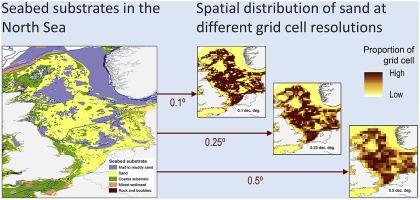
Abstract Seabed substrates have the capacity to support a variety of marine communities. However, habitats provided by natural substrates are increasingly modified and supplemented by man-made structures. These provide hard surfaces suitable for colonisation by sedentary and/or non-migratory organisms, and may contribute to an interconnected system of benefit to diverse marine populations. Robust assessment of the influence of such structures is, therefore, a necessary consideration for their long-term management. The challenge of compiling and manipulating data for input to two North Sea models is described. Source data were processed and gridded at three different spatial resolutions to investigate the effect of scale on spatial relationships. Choice of grid size was found to exacerbate existing uncertainty in location and extent of features, influencing interpretation of their spatial distributions at the different scales examined. The small spatial footprint of man-made structures, compared with natural substrates, may lead to underestimation of the influence of the former at coarser model scales. Choices must be made between data availability, spatial resolution and accuracy, modelling and analysis requirements, to identify robust approaches to reliable outcomes. Model sensitivity and uncertainty analyses are recommended for application in data-limited situations. Greater openness and cooperation in data-sharing is required for robust scientific modelling to underpin decision-making in the marine environment.
中文翻译:

评估海洋空间数据分辨率和稳健性的差异:北海案例研究
摘要 海底基质具有支持各种海洋群落的能力。然而,由天然基质提供的栖息地越来越多地被人造结构改造和补充。这些提供了适合定居和/或非迁徙生物定殖的坚硬表面,并可能有助于建立一个有益于不同海洋种群的相互关联的系统。因此,对此类结构的影响进行稳健评估是对其长期管理的必要考虑。描述了编译和处理输入到两个北海模型的数据的挑战。以三种不同的空间分辨率对源数据进行处理和网格化,以研究尺度对空间关系的影响。发现网格大小的选择会加剧特征位置和范围的现有不确定性,影响他们在不同尺度上的空间分布的解释。与天然基质相比,人造结构的空间足迹较小,可能会导致在较粗的模型尺度上低估前者的影响。必须在数据可用性、空间分辨率和准确性、建模和分析要求之间做出选择,以确定可靠结果的稳健方法。建议在数据有限的情况下应用模型敏感性和不确定性分析。强有力的科学建模需要在数据共享方面更加开放和合作,以支持海洋环境的决策。可能导致在较粗的模型尺度上低估前者的影响。必须在数据可用性、空间分辨率和准确性、建模和分析要求之间做出选择,以确定可靠结果的稳健方法。建议在数据有限的情况下应用模型敏感性和不确定性分析。强有力的科学建模需要在数据共享方面更加开放和合作,以支持海洋环境的决策。可能导致在较粗的模型尺度上低估前者的影响。必须在数据可用性、空间分辨率和准确性、建模和分析要求之间做出选择,以确定可靠结果的稳健方法。建议在数据有限的情况下应用模型敏感性和不确定性分析。强有力的科学建模需要在数据共享方面更加开放和合作,以支持海洋环境的决策。
更新日期:2020-07-01
中文翻译:
评估海洋空间数据分辨率和稳健性的差异:北海案例研究
摘要 海底基质具有支持各种海洋群落的能力。然而,由天然基质提供的栖息地越来越多地被人造结构改造和补充。这些提供了适合定居和/或非迁徙生物定殖的坚硬表面,并可能有助于建立一个有益于不同海洋种群的相互关联的系统。因此,对此类结构的影响进行稳健评估是对其长期管理的必要考虑。描述了编译和处理输入到两个北海模型的数据的挑战。以三种不同的空间分辨率对源数据进行处理和网格化,以研究尺度对空间关系的影响。发现网格大小的选择会加剧特征位置和范围的现有不确定性,影响他们在不同尺度上的空间分布的解释。与天然基质相比,人造结构的空间足迹较小,可能会导致在较粗的模型尺度上低估前者的影响。必须在数据可用性、空间分辨率和准确性、建模和分析要求之间做出选择,以确定可靠结果的稳健方法。建议在数据有限的情况下应用模型敏感性和不确定性分析。强有力的科学建模需要在数据共享方面更加开放和合作,以支持海洋环境的决策。可能导致在较粗的模型尺度上低估前者的影响。必须在数据可用性、空间分辨率和准确性、建模和分析要求之间做出选择,以确定可靠结果的稳健方法。建议在数据有限的情况下应用模型敏感性和不确定性分析。强有力的科学建模需要在数据共享方面更加开放和合作,以支持海洋环境的决策。可能导致在较粗的模型尺度上低估前者的影响。必须在数据可用性、空间分辨率和准确性、建模和分析要求之间做出选择,以确定可靠结果的稳健方法。建议在数据有限的情况下应用模型敏感性和不确定性分析。强有力的科学建模需要在数据共享方面更加开放和合作,以支持海洋环境的决策。


 京公网安备 11010802027423号