当前位置:
X-MOL 学术
›
Ocean Coast Manage.
›
论文详情
Our official English website, www.x-mol.net, welcomes your
feedback! (Note: you will need to create a separate account there.)
Exploring gaps in mapping marine ecosystem services: A benchmark analysis
Ocean & Coastal Management ( IF 4.8 ) Pub Date : 2020-07-01 , DOI: 10.1016/j.ocecoaman.2020.105193 L. Nahuelhual , X. Vergara , F. Bozzeda , G. Campos , M.D. Subida , L. Outeiro , S. Villasante , M. Fernández
Ocean & Coastal Management ( IF 4.8 ) Pub Date : 2020-07-01 , DOI: 10.1016/j.ocecoaman.2020.105193 L. Nahuelhual , X. Vergara , F. Bozzeda , G. Campos , M.D. Subida , L. Outeiro , S. Villasante , M. Fernández
|
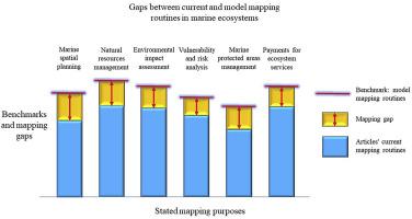
Abstract We assessed the gaps between current and “model mapping routines”, which represent a benchmark for mapping marine ecosystem services (ESs). Model mapping routines comprised 17 selected variables and their best-rated alternatives depending on the mapping purpose, namely, marine spatial planning, environmental impact assessment, vulnerability and risk analysis, marine protected areas management, payments for ecosystem services, and natural resources management. We conducted a systematic search of articles (n = 64) from which information on the 17 variables and their alternatives was retrieved. We assessed gaps using similarity matrices, according to the co-occurrence index. The largest gaps (as measured by average distances >0.5 between actual and best options) occurred in articles reporting natural resources management as purpose, whereas the smallest were related to marine protected areas management and payments for ecosystem services. The gaps were due to departures in different individual variables. For example, in the case of marine spatial planning the omission of tradeoffs, scenario analysis, multiple scales, and threshold analyses explained the gap, whereas in vulnerability and risk assessment the omission of thresholds, the lack of consistency of the indicators used, and the absence of a definition of ESs explained the gap. We trust that this study will help to recognize that ESs mapping studies should be guided by the purpose of a given intervention rather than by the technical capacities and disciplines of the researchers, if the ESs approach expects to reach a real impact into public policies.
中文翻译:

探索海洋生态系统服务制图的差距:基准分析
摘要 我们评估了当前和“模型制图程序”之间的差距,它们代表了绘制海洋生态系统服务 (ES) 的基准。模型制图程序包括 17 个选定的变量及其根据制图目的获得最佳评级的替代方案,即海洋空间规划、环境影响评估、脆弱性和风险分析、海洋保护区管理、生态系统服务支付和自然资源管理。我们对文章 (n = 64) 进行了系统搜索,从中检索了有关 17 个变量及其替代方案的信息。我们根据共现指数使用相似矩阵评估差距。最大的差距(通过实际和最佳选择之间的平均距离 >0.5 来衡量)出现在将自然资源管理作为目的的文章中,而最小的则与海洋保护区的管理和生态系统服务的支付有关。差距是由于不同个体变量的偏离造成的。例如,在海洋空间规划的情况下,权衡、情景分析、多尺度和阈值分析的遗漏解释了差距,而在脆弱性和风险评估中,阈值的遗漏、所用指标缺乏一致性以及缺乏对 ES 的定义解释了这一差距。我们相信,如果 ESs 方法希望对公共政策产生真正的影响,这项研究将有助于认识到 ESs 绘图研究应该以特定干预的目的为指导,而不是以研究人员的技术能力和学科为指导。
更新日期:2020-07-01
中文翻译:
探索海洋生态系统服务制图的差距:基准分析
摘要 我们评估了当前和“模型制图程序”之间的差距,它们代表了绘制海洋生态系统服务 (ES) 的基准。模型制图程序包括 17 个选定的变量及其根据制图目的获得最佳评级的替代方案,即海洋空间规划、环境影响评估、脆弱性和风险分析、海洋保护区管理、生态系统服务支付和自然资源管理。我们对文章 (n = 64) 进行了系统搜索,从中检索了有关 17 个变量及其替代方案的信息。我们根据共现指数使用相似矩阵评估差距。最大的差距(通过实际和最佳选择之间的平均距离 >0.5 来衡量)出现在将自然资源管理作为目的的文章中,而最小的则与海洋保护区的管理和生态系统服务的支付有关。差距是由于不同个体变量的偏离造成的。例如,在海洋空间规划的情况下,权衡、情景分析、多尺度和阈值分析的遗漏解释了差距,而在脆弱性和风险评估中,阈值的遗漏、所用指标缺乏一致性以及缺乏对 ES 的定义解释了这一差距。我们相信,如果 ESs 方法希望对公共政策产生真正的影响,这项研究将有助于认识到 ESs 绘图研究应该以特定干预的目的为指导,而不是以研究人员的技术能力和学科为指导。


 京公网安备 11010802027423号