当前位置:
X-MOL 学术
›
Earth Surf.Process. Land.
›
论文详情
Our official English website, www.x-mol.net, welcomes your
feedback! (Note: you will need to create a separate account there.)
Peripheral gully and landslide erosion on an extreme anthropogenic landscape produced by mountaintop removal coal mining
Earth Surface Processes and Landforms ( IF 2.8 ) Pub Date : 2020-05-01 , DOI: 10.1002/esp.4867 Miles Reed 1, 2 , Steve Kite 1
Earth Surface Processes and Landforms ( IF 2.8 ) Pub Date : 2020-05-01 , DOI: 10.1002/esp.4867 Miles Reed 1, 2 , Steve Kite 1
Affiliation
|
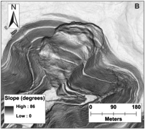
Mountaintop removal/valley fill coal mining (MTR/VF) in central Appalachia has buried an estimated 4000 km of headwater streams, but the long‐term geomorphic consequences of the anthropogenic valley fills and associated mined landscapes are poorly understood. These anthropogenic landscapes are not intended to be maintained in perpetuity once reclamation is complete. Here we present the first ever field‐based study of erosional landforms on this type of mined landscape paired with the subsequent examination of 10 regional LiDAR (light detection and ranging) datasets for gullies and landslides in a transect from eastern Kentucky to central West Virginia. Field observations indicate that overtopping of or intentional discharge from drainage systems and overtopping of valley fill terraces can initiate gullying. We manually extracted 1328 gullies from 512 km2 of mined landscape within the LiDAR datasets. Gullies are predominantly located along the perimeter of the mined landscape with the majority of gullies associated with drainage systems. The number of gullies linearly scales with mined area (R2 = 0.66). We observed 387 landslides along the perimeter of MTR/VF. Within the datasets, landslides per km2 ranged from 0.1 to 3.9. We observed 34 landslides within fully reclaimed valley fills, a heretofore undocumented phenomenon. Over 90% of these landslides were in Kentucky datasets, which covered only 47% of total mined area analyzed. Previously measured regional differences in the angle of friction of mine spoils or construction practices may explain the abundance of gullies and elevated level of landslide occurrence in eastern Kentucky valley fills relative to West Virginia. Observations of erosion on regionally extensive MTR/VF landscapes warrant further study to better ascertain ecological impacts. Large‐scale alteration by surface mining in steep landscapes may generally lead to peripheral gully erosion. © 2020 John Wiley & Sons, Ltd.
中文翻译:

山顶去除煤矿开采导致的极端人为景观上的周边沟壑和滑坡侵蚀
阿巴拉契亚中部的山顶清除/谷地补给煤开采(MTR / VF)已掩埋了约4000 km的源头水流,但是人为的河谷填埋物和相关的开采地貌的长期地貌后果却鲜为人知。一旦开垦完成,就不会永久保留这些人为景观。在这里,我们介绍了有史以来首次针对此类矿山景观的侵蚀性地形的野外研究,并随后对从肯塔基州东部到西维吉尼亚州中部的一条样带中的沟壑和滑坡进行了10个区域LiDAR(光探测和测距)数据集的检查。实地观察表明,排水系统的水位过高或蓄意排放以及山谷填土平台的水位过高都会引发沟壑。LiDAR数据集中的2个已开采景观。沟壑主要位于矿山周围,大部分沟壑与排水系统有关。沟壑的数量与开采面积成线性比例(R 2 = 0.66)。我们在MTR / VF周边观察到387处滑坡。在数据集中,每km 2的滑坡范围从0.1到3.9。我们在完全填满的山谷填充物中观察到了34个滑坡,这是迄今为止没有记载的现象。这些滑坡中超过90%位于肯塔基州的数据集中,仅覆盖了分析的总矿区的47%。先前测得的地雷的摩擦角或建筑实践中的区域差异可能解释了相对于西弗吉尼亚州而言,肯塔基州东部山谷填充物中大量的沟壑和高水平的滑坡发生。在区域广泛的MTR / VF景观上的侵蚀观察值得进一步研究,以更好地确定生态影响。在陡峭的景观中通过地面采矿进行的大规模改造通常可能导致外围沟壑侵蚀。©2020 John Wiley&Sons,Ltd.
更新日期:2020-05-01
中文翻译:
山顶去除煤矿开采导致的极端人为景观上的周边沟壑和滑坡侵蚀
阿巴拉契亚中部的山顶清除/谷地补给煤开采(MTR / VF)已掩埋了约4000 km的源头水流,但是人为的河谷填埋物和相关的开采地貌的长期地貌后果却鲜为人知。一旦开垦完成,就不会永久保留这些人为景观。在这里,我们介绍了有史以来首次针对此类矿山景观的侵蚀性地形的野外研究,并随后对从肯塔基州东部到西维吉尼亚州中部的一条样带中的沟壑和滑坡进行了10个区域LiDAR(光探测和测距)数据集的检查。实地观察表明,排水系统的水位过高或蓄意排放以及山谷填土平台的水位过高都会引发沟壑。LiDAR数据集中的2个已开采景观。沟壑主要位于矿山周围,大部分沟壑与排水系统有关。沟壑的数量与开采面积成线性比例(R 2 = 0.66)。我们在MTR / VF周边观察到387处滑坡。在数据集中,每km 2的滑坡范围从0.1到3.9。我们在完全填满的山谷填充物中观察到了34个滑坡,这是迄今为止没有记载的现象。这些滑坡中超过90%位于肯塔基州的数据集中,仅覆盖了分析的总矿区的47%。先前测得的地雷的摩擦角或建筑实践中的区域差异可能解释了相对于西弗吉尼亚州而言,肯塔基州东部山谷填充物中大量的沟壑和高水平的滑坡发生。在区域广泛的MTR / VF景观上的侵蚀观察值得进一步研究,以更好地确定生态影响。在陡峭的景观中通过地面采矿进行的大规模改造通常可能导致外围沟壑侵蚀。©2020 John Wiley&Sons,Ltd.


 京公网安备 11010802027423号