当前位置:
X-MOL 学术
›
Earth Surf.Process. Land.
›
论文详情
Our official English website, www.x-mol.net, welcomes your
feedback! (Note: you will need to create a separate account there.)
Mapping rainstorm erosion associated with an individual storm from InSAR coherence loss validated by field evidence for the Atacama Desert
Earth Surface Processes and Landforms ( IF 2.8 ) Pub Date : 2020-04-30 , DOI: 10.1002/esp.4868 Albert Cabré 1, 2 , Dominique Remy 3 , Germán Aguilar 2 , Sebastien Carretier 3 , Rodrigo Riquelme 1
Earth Surface Processes and Landforms ( IF 2.8 ) Pub Date : 2020-04-30 , DOI: 10.1002/esp.4868 Albert Cabré 1, 2 , Dominique Remy 3 , Germán Aguilar 2 , Sebastien Carretier 3 , Rodrigo Riquelme 1
Affiliation
|
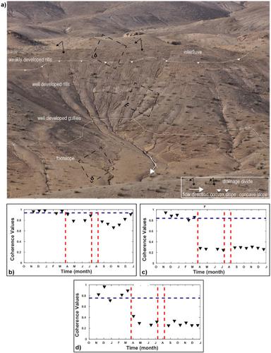
Extreme high‐magnitude and low‐frequency storm events in arid zones provide the necessary runoff to entrain sediments from source areas and therefore dictate the linkages between hillslopes and channels. Nevertheless, the erosive impact of large storms remains difficult to predict. Most of the uncertainty lies in the lack of topographic change maps associated with single hydro‐meteorological events. Consequently, event‐based erosion models are poorly constrained and their extrapolation over long time periods remains uncertain. In this study, a 15‐month Sentinel‐1A coherence time series, optical and field data are used to map the spatial patterns of erosion after the 5‐day storm occurred on March 2015, in the Atacama Desert. The coherence change detection (CCD) analysis suggests that temporal loss of coherence is related to variations in soil moisture, while permanent loss of coherence is related to modification of soil texture by erosion and sedimentation. Importantly, permanent loss of coherence is more apparent on gentle rather than steeper slopes, likely reflecting differences in regolith cover and thickness. These findings can contradict the landscape models predicting higher erosion on steeper hillslopes. The CCD technique represents a promising tool for analysing and modelling sediment connectivity in arid areas, giving a clear picture of the relation between sediment sources and sink pathways. © 2020 John Wiley & Sons, Ltd.
中文翻译:

通过InSAR相干性损失绘制与单个风暴相关的暴雨侵蚀图,并通过阿塔卡马沙漠的现场证据进行了验证
干旱地区的极端高强度和低频风暴事件提供了必要的径流,以夹带来自源区的沉积物,因此决定了山坡和河道之间的联系。尽管如此,大风暴的侵蚀性影响仍然难以预测。大多数不确定性在于缺乏与单个水文气象事件相关的地形变化图。因此,基于事件的侵蚀模型的约束性很差,并且在长时间内的外推性仍然不确定。在这项研究中,使用了一个15个月的Sentinel-1A相干时间序列,光学和野外数据来绘制2015年3月在阿塔卡马沙漠发生5天暴风雨之后侵蚀的空间格局。相干性变化检测(CCD)分析表明,相干性的暂时损失与土壤水分的变化有关,而永久性的相干性损失与侵蚀和沉降对土壤质地的改变有关。重要的是,在平缓而不是陡峭的斜坡上,永久性的连贯性损失更为明显,这很可能反映了硬石膏覆盖层和厚度的差异。这些发现可能与预测更陡峭的山坡侵蚀程度更高的景观模型相矛盾。CCD技术是用于分析和模拟干旱地区泥沙连通性的有前途的工具,可以清晰地显示泥沙源与汇流径之间的关系。分级为4 +©2020 John Wiley&Sons,Ltd. 永久性的连贯性损失在平缓而不是陡峭的斜坡上更为明显,这很可能反映了硬质覆盖层和厚度的差异。这些发现可能与预测更陡峭的山坡侵蚀加剧的景观模型相矛盾。CCD技术是用于分析和模拟干旱地区泥沙连通性的有前途的工具,可以清晰地显示泥沙源与汇流径之间的关系。分级为4 +©2020 John Wiley&Sons,Ltd. 永久性的连贯性损失在平缓而不是陡峭的斜坡上更为明显,这很可能反映了硬质覆盖层和厚度的差异。这些发现可能与预测更陡峭的山坡侵蚀程度更高的景观模型相矛盾。CCD技术是用于分析和模拟干旱地区泥沙连通性的有前途的工具,可以清晰地显示泥沙源与汇流径之间的关系。分级为4 +©2020 John Wiley&Sons,Ltd. 清楚地显示了沉积物来源与汇途径之间的关系。分级为4 +©2020 John Wiley&Sons,Ltd. 清楚地显示了沉积物来源与汇途径之间的关系。分级为4 +©2020 John Wiley&Sons,Ltd.
更新日期:2020-04-30
中文翻译:
通过InSAR相干性损失绘制与单个风暴相关的暴雨侵蚀图,并通过阿塔卡马沙漠的现场证据进行了验证
干旱地区的极端高强度和低频风暴事件提供了必要的径流,以夹带来自源区的沉积物,因此决定了山坡和河道之间的联系。尽管如此,大风暴的侵蚀性影响仍然难以预测。大多数不确定性在于缺乏与单个水文气象事件相关的地形变化图。因此,基于事件的侵蚀模型的约束性很差,并且在长时间内的外推性仍然不确定。在这项研究中,使用了一个15个月的Sentinel-1A相干时间序列,光学和野外数据来绘制2015年3月在阿塔卡马沙漠发生5天暴风雨之后侵蚀的空间格局。相干性变化检测(CCD)分析表明,相干性的暂时损失与土壤水分的变化有关,而永久性的相干性损失与侵蚀和沉降对土壤质地的改变有关。重要的是,在平缓而不是陡峭的斜坡上,永久性的连贯性损失更为明显,这很可能反映了硬石膏覆盖层和厚度的差异。这些发现可能与预测更陡峭的山坡侵蚀程度更高的景观模型相矛盾。CCD技术是用于分析和模拟干旱地区泥沙连通性的有前途的工具,可以清晰地显示泥沙源与汇流径之间的关系。分级为4 +©2020 John Wiley&Sons,Ltd. 永久性的连贯性损失在平缓而不是陡峭的斜坡上更为明显,这很可能反映了硬质覆盖层和厚度的差异。这些发现可能与预测更陡峭的山坡侵蚀加剧的景观模型相矛盾。CCD技术是用于分析和模拟干旱地区泥沙连通性的有前途的工具,可以清晰地显示泥沙源与汇流径之间的关系。分级为4 +©2020 John Wiley&Sons,Ltd. 永久性的连贯性损失在平缓而不是陡峭的斜坡上更为明显,这很可能反映了硬质覆盖层和厚度的差异。这些发现可能与预测更陡峭的山坡侵蚀程度更高的景观模型相矛盾。CCD技术是用于分析和模拟干旱地区泥沙连通性的有前途的工具,可以清晰地显示泥沙源与汇流径之间的关系。分级为4 +©2020 John Wiley&Sons,Ltd. 清楚地显示了沉积物来源与汇途径之间的关系。分级为4 +©2020 John Wiley&Sons,Ltd. 清楚地显示了沉积物来源与汇途径之间的关系。分级为4 +©2020 John Wiley&Sons,Ltd.


 京公网安备 11010802027423号