Marine Geology ( IF 2.6 ) Pub Date : 2020-04-06 , DOI: 10.1016/j.margeo.2020.106191 Stefano Furlani
|
This work deals with recent advances in scientific snorkel surveying, starting from the results of several case studies in the Mediterranean between 2012 and 2018, for a total survey length of 531.4 km, with the aim of illustrating the pros and cons.
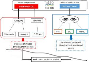
The snorkel survey method, described here, also called ‘Geoswim’, allows rough-and-ready surveys of long sectors of rocky coasts. In particular, it is able to collect time-lapse images perpendicularly to the coastline and observe long sectors of rocky coastline, with particular reference to the tidal zone. In addition to the photographic survey along the coast, rough measures, lateral variations in geomorphological, geological, biological, and ecological parameters and the collection of hydrological data are usually performed during the work. The expeditions also provide the opportunity to produce large databases of coastal landforms such as coastal sea caves and tidal notches. The data collected can be improved by additional on-the-spot observations.
The evaluation of the methodology here proposed was based on the results of SWOT analysis starting from the results and the experience of previous expeditions. Geoswim is the first snorkel approach that allows the collection of large amount of multidisciplinary data along wide sectors of rocky coastline. At the moment, this approach is the best and probably the only technique for characterizing the tidal and nearshore zone, but also to collect observational data of prominent objects along rocky coasts. However, snorkel observations are affected by limitations similar to those of terrestrial field surveys. The ability to observe specific forms or phenomena increases through the practice of field observation and are strongly observer-influenced. Sheltered sea basins are better suited than ocean basins, where tides and wave energy are generally higher. Data collection is also affected by weather and sea conditions. The quality of time-lapse images and videos may be reduced as a result of breakers at the cliffs, producing images that cannot be used for subsequent analysis. As for external factors, some sectors of the coast may be closed due to local restrictions on field activities.
中文翻译:
通过浮潜调查整合岩石海岸的观测目标和仪器数据:一种方法学方法
这项工作涉及科学浮潜调查的最新进展,从2012年至2018年间在地中海进行的一些案例研究的结果开始,调查总长度为531.4公里,目的是说明其优缺点。
在此描述的通气管测量方法也称为“ Geoswim”,可以粗略地进行岩石海岸长段的测量。特别是,它能够收集垂直于海岸线的延时图像并观察岩石海岸线的长扇区,尤其是参照潮汐带。除了沿海岸的摄影调查外,通常在工作期间还要进行粗略的测量,地貌,地质,生物学和生态参数的横向变化以及水文数据的收集。这次探险还提供了建立大型沿海地貌数据库的机会,例如沿海海洞和潮汐口。可以通过其他现场观察来改善收集的数据。
这里提出的方法的评估是基于SWOT分析的结果,该结果是从先前考察的结果和经验开始的。Geoswim是第一种浮潜方法,它允许在多岩石的海岸线上收集大量的多学科数据。目前,这种方法是表征潮汐和近岸带的最佳方法,可能是唯一的方法,而且是沿岩石海岸收集重要物体观测数据的最佳方法。但是,浮潜观测受到与陆地野外调查相似的局限性的影响。通过现场观察的实践,观察特定形式或现象的能力会增强,并且受到观察者的强烈影响。庇护海域比海域更适合,潮汐和波浪能通常较高。数据收集还受到天气和海况的影响。延时图像和视频的质量可能会由于悬崖上的破碎机而降低,从而产生无法用于后续分析的图像。至于外部因素,由于当地对野外活动的限制,沿海的某些地区可能被关闭。


 京公网安备 11010802027423号